
Photo: Wikipedia
Strategic Assessment of Port Aransas, TX
Multiple tactical vulnerabilities. Population density, target proximity, or disaster risk are likely compounding. A retreat property and exit planning is required.
What does the Strategic Assessment tell us?
Our Strategic Assessment grades tactical survivability of an area. Major population centers, military targets, fallout zones, natural disasters, and border exposure all drive risk — lower exposure means a more defensible position in a crisis.
This is heavily inspired by Joel Skousen's Strategic Relocation book. Highly recommended you checkout the book ($)What does this tell us?
Our Strategic Assessment grades tactical survivability of an area. Major population centers, military targets, fallout zones, natural disasters, and border exposure all drive risk — lower exposure means a more defensible position in a crisis.
This is heavily inspired by Joel Skousen's Strategic Relocation book. Highly recommended you checkout the book ($)Strategic Pillars

Key Distances
Regional Safe Places
Below is our recommended "safe zones" in Texas and the surrounding area based on our strategic heuristics. For most people, it's unrealistic to live in a “safe zone” full-time due to work, family or other personal reasons. They tend to be more rural. However, many of these areas are perfect for second homes and retreat properties that double as a vacation home or even a short-term rental.


Important Note: For informational purposes only. This does not mean nothing bad ever happens in the green zones. Please use common sense. This is based on public data and modeled with AI. We tried to take a conservative approach but mistakes happen. We update this regularly as new information becomes available.
Solar Generator Recommendations
Backup power matters more here than in safer locations. We've picked three solar generators across budgets and capacity tiers — start with the budget unit if you only need a few essentials, or step up if you want to run a fridge and HVAC for days at a time.

Jackery Portable Power Station Explorer 300
Budget OptionPower on the Go: Weighing only 11 lbs, it's convenient to set up and store with book-sized foldable solar panels

BLUETTI Portable Power Station AC180
Designed for both indoor and outdoor scenarios, AC180 is highly capable as it has a robost capacity and continuous output power.

EF ECOFLOW DELTA Pro Ultra Power Station
Upgraded PickEcoFlow DELTA Pro Ultra is a whole-home energy system designed to grow with your family. Integrated with the Smart Home Panel 2, it scales to meet your evolving energy needs — keeping your home powered, intelligent, and secure through every stage of life.
We earn a commission, at no additional cost to you.
Strategic Assessment Analysis
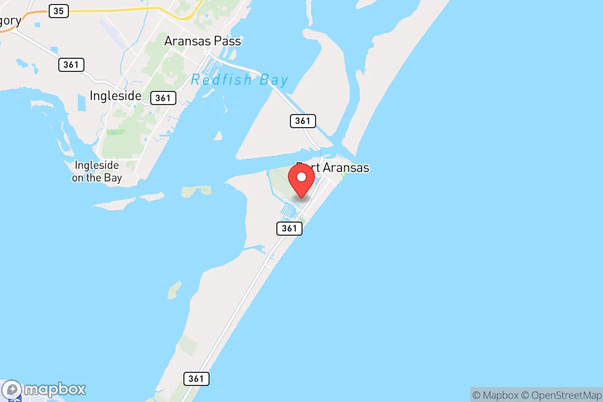
Port Aransas, Texas, occupies a unique strategic position on Mustang Island, a barrier island in the Gulf of Mexico, offering both significant natural advantages and serious exposure risks for a relocator with a survivalist mindset. Its location roughly 30 miles from Corpus Christi and 200 miles from San Antonio provides a buffer from the immediate fallout of major urban unrest, while the Gulf and the Intracoastal Waterway offer natural defensive barriers and potential escape routes. However, this coastal geography also places the community directly in the path of hurricane storm surges and rising sea levels, making resilience a constant, active requirement rather than a passive benefit.
Geographic position and natural defensive advantages
Port Aransas sits at the northern tip of Mustang Island, with the Gulf of Mexico to the east and Corpus Christi Bay to the west. This island geography creates a natural moat: access is limited to two primary routes—State Highway 361 from the north (via the Aransas Pass Causeway) and the Port Aransas Ferry from the south (connecting to the mainland at Aransas Pass). In a scenario of civic unrest or mass casualty events, these chokepoints can be monitored and, if necessary, controlled, providing a defensible perimeter that mainland communities lack. The surrounding waters—the Gulf, the bay, and the Intracoastal Waterway—offer multiple avenues for waterborne resupply, evacuation, or retreat, a critical advantage for those who maintain a boat or kayak. The area’s low population density (roughly 3,000 year-round residents, swelling to 20,000+ in summer) means fewer people to compete with for resources during a crisis, though the seasonal influx complicates long-term planning. The flat, sandy terrain offers limited cover, but the dense coastal scrub and dunes can provide concealment for small groups. The proximity to the Padre Island National Seashore, a 70-mile stretch of undeveloped coastline, offers a vast, low-traffic buffer zone to the south, ideal for extended retreat or foraging.
Risks, exposures, and proximity to fallout-relevant landmarks
The most immediate and recurring threat is hurricane storm surge. Port Aransas is in a high-risk surge zone, with Category 3+ storms capable of inundating the entire island under 10-15 feet of water. The 2017 Hurricane Harvey demonstrated this brutally—the storm’s eyewall passed directly over the area, causing catastrophic damage and a mandatory evacuation that lasted weeks. For a prepper, this means any permanent residence must be elevated, flood-insured, and equipped with a pre-planned evacuation route and a secondary cache inland (e.g., near Refugio or Beeville). The island’s low elevation (average 5-10 feet above sea level) offers no natural high ground. Beyond weather, the proximity to Corpus Christi (home to the Port of Corpus Christi, a major oil and chemical hub) introduces a secondary risk: a major industrial accident or terrorist strike at the port could release toxic plumes or trigger a cascading disaster that affects downwind Port Aransas. The nearby Naval Air Station Corpus Christi and the Army’s Corpus Christi Army Depot are potential targets in a conflict scenario, though the 30-mile distance provides some buffer from direct blast effects. The ferry system itself is a vulnerability—a single point of failure that, if disabled (by storm, accident, or sabotage), would trap residents on the island. The only other egress is the causeway, which is also vulnerable to storm surge and bridge failure.
Practical resilience for a relocator: food, water, energy, and defensibility
Port Aransas offers moderate practical resilience, but it requires deliberate preparation. Water is the most critical vulnerability: the island relies entirely on a single water main from the mainland (via the causeway) and a local desalination plant. A prolonged power outage or pipeline break would leave residents without potable water within 24-48 hours. Preppers should install rainwater catchment systems (the area averages 35 inches of rain annually, mostly in spring and fall) and store at least 2-3 weeks of water per person. Food security is mixed: the Gulf provides excellent fishing (redfish, trout, flounder, and shrimp), and the surrounding bays offer crabbing and oyster harvesting. However, commercial agriculture is nonexistent on the island; any long-term food production would require mainland access or a greenhouse setup. The local grocery store (a single IGA) is small and would be stripped quickly in a crisis. Energy is a bright spot: the area has strong solar potential (over 260 sunny days per year) and consistent coastal winds, making off-grid solar and small wind turbines viable. Natural gas is piped in, but a propane tank backup for cooking and heating is wise. Defensibility is situational: the island’s small size and limited access points make it relatively easy to secure a neighborhood or a single property, but the flat terrain offers little cover. A home with a raised foundation, metal roof, and reinforced windows (for storm and ballistic protection) is ideal. The local police force is small (under 20 officers), so self-reliance is the norm. The community is tight-knit and largely conservative, with a strong fishing and outdoor culture—neighbors are likely to band together rather than turn on each other, a significant social resilience factor.
The overall strategic picture for Port Aransas is one of high reward balanced by high risk. It offers a defensible, low-density coastal refuge with excellent natural resources (fishing, solar, wind) and a like-minded community, but it demands serious preparation for the twin threats of hurricane surge and supply-chain fragility. For a relocator willing to invest in elevation, water storage, and a mainland bug-out location, it can serve as a viable long-term retreat—especially if the goal is to be far enough from major cities to avoid the worst of unrest, yet close enough to the Gulf for maritime options. The key is to treat Port Aransas not as a passive safe haven, but as an active base that requires constant maintenance and a clear evacuation plan. For those who can handle the weather risk and the isolation, it’s a solid choice in a volatile world.
* Values derived from national, state, county, city and local statistics and may differ in a specific area. Last updated: 2026-05-12T00:15:21.000Z
Narrative content on this page is AI-generated and may contain mistakes. Verify any details that matter before acting on them.
ReloMaps may earn a commission from affiliate links at no extra cost to you.