
Photo: Wikipedia
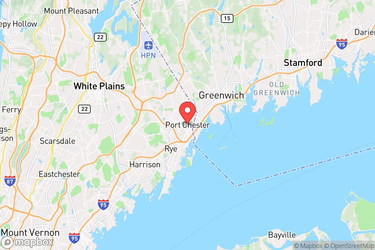
Strategic Assessment of Port Chester, NY
High tactical risk. This location is likely close to major population centers, strategic targets, or sits in a high-disaster corridor. A retreat property and careful exit planning is required.
What does the Strategic Assessment tell us?
Our Strategic Assessment grades tactical survivability of an area. Major population centers, military targets, fallout zones, natural disasters, and border exposure all drive risk — lower exposure means a more defensible position in a crisis.
This is heavily inspired by Joel Skousen's Strategic Relocation book. Highly recommended you checkout the book ($)What does this tell us?
Our Strategic Assessment grades tactical survivability of an area. Major population centers, military targets, fallout zones, natural disasters, and border exposure all drive risk — lower exposure means a more defensible position in a crisis.
This is heavily inspired by Joel Skousen's Strategic Relocation book. Highly recommended you checkout the book ($)Strategic Pillars

Key Distances
Regional Safe Places
Below is our recommended "safe zones" in New York and the surrounding area based on our strategic heuristics. For most people, it's unrealistic to live in a “safe zone” full-time due to work, family or other personal reasons. They tend to be more rural. However, many of these areas are perfect for second homes and retreat properties that double as a vacation home or even a short-term rental.


Important Note: For informational purposes only. This does not mean nothing bad ever happens in the green zones. Please use common sense. This is based on public data and modeled with AI. We tried to take a conservative approach but mistakes happen. We update this regularly as new information becomes available.
Solar Generator Recommendations
Backup power matters more here than in safer locations. We've picked three solar generators across budgets and capacity tiers — start with the budget unit if you only need a few essentials, or step up if you want to run a fridge and HVAC for days at a time.

Jackery Portable Power Station Explorer 300
Budget OptionPower on the Go: Weighing only 11 lbs, it's convenient to set up and store with book-sized foldable solar panels

BLUETTI Portable Power Station AC180
Designed for both indoor and outdoor scenarios, AC180 is highly capable as it has a robost capacity and continuous output power.

EF ECOFLOW DELTA Pro Ultra Power Station
Upgraded PickEcoFlow DELTA Pro Ultra is a whole-home energy system designed to grow with your family. Integrated with the Smart Home Panel 2, it scales to meet your evolving energy needs — keeping your home powered, intelligent, and secure through every stage of life.
We earn a commission, at no additional cost to you.
Strategic Assessment Analysis
Port Chester, New York, presents a complex strategic picture for the conservative prepper or survivalist. Its primary advantage is its location as a resilient, self-contained village on the Connecticut border, offering a blend of suburban density and access to critical infrastructure. However, its proximity to New York City and the I-95 corridor introduces significant vulnerabilities that must be weighed carefully. For the relocator prioritizing preparedness, Port Chester is a mixed bag: it offers defensible pockets and strong local governance, but its position in a high-value, high-risk region demands a clear-eyed assessment of exposure to fallout, unrest, and supply chain disruption.
Geographic position and natural advantages for a prepared relocator
Port Chester sits at the southwestern edge of Westchester County, directly abutting Greenwich, Connecticut. This border location is a double-edged sword but offers a key strategic benefit: it provides a natural escape route into less densely populated New England via Connecticut Route 15 or the Merritt Parkway, which runs just north of the village. The area is part of the Hudson River watershed, with the Byram River running through the village, offering a modest but reliable freshwater source. The terrain is gently rolling, with pockets of wooded residential areas—particularly in the neighborhoods north of the Boston Post Road (US-1)—that provide some natural cover and defensible positions. The village's compact, walkable downtown core (roughly 1.5 square miles) means that a prepared individual can maintain a low profile while still having access to essential services within a 10-minute walk. The local climate is temperate, with four distinct seasons, which supports small-scale gardening and rainwater collection, though winters require robust heating and fuel storage. For the prepper, the key natural advantage is the ability to move north or east into less populated terrain within 15 minutes by vehicle, while still being able to monitor activity along the I-95 corridor from elevated positions in the village's northern hills.
Risks, exposures, and proximity to fallout-relevant landmarks
The most significant risk for a Port Chester relocator is its proximity to New York City, just 25 miles south. In a scenario involving civil unrest, mass casualty events, or a major disaster, Port Chester sits directly in the path of any exodus from the city. The I-95, I-287, and Metro-North rail lines all converge near the village, making it a natural chokepoint for fleeing populations. The Indian Point Energy Center, a decommissioned nuclear plant, is roughly 20 miles north in Buchanan, NY. While decommissioned, the site still stores spent fuel, and any incident there would place Port Chester within a potential fallout zone depending on wind direction. Additionally, the village is within 10 miles of the Westchester County Airport (HPN), a general aviation and corporate jet hub that could become a target or a source of chaos during a national emergency. The village's own infrastructure—including a wastewater treatment plant on the Byram River and a major electrical substation on Westchester Avenue—are vulnerable points. For the survivalist, the density of the village (over 30,000 people in a small area) means that any localized disaster could quickly overwhelm local resources. The presence of multiple immigrant communities and a high proportion of renters (over 60% of housing units) suggests that in a crisis, the population could be transient and less likely to have deep local ties or preps, potentially leading to rapid social breakdown.
Practical resilience for a relocator: food, water, energy, and defensibility
For the individual or family looking to establish a resilient household in Port Chester, the practical picture is mixed but workable. Water: The village draws its municipal water from the Catskill/Delaware watershed via New York City's system, which is a single-point-of-failure vulnerability. A prepared relocator should install a 1,500-gallon cistern for rainwater catchment and have a Berkey or similar gravity filter. The Byram River is a backup source, but it runs through industrial areas and requires heavy filtration. Food: Port Chester has a strong local food scene, with multiple supermarkets (ShopRite, C-Town) and a weekly farmers market at Lyon Park from June to November. However, for long-term storage, the village lacks a dedicated bulk food store; relocators should plan to drive 15 minutes to Costco in New Rochelle or BJ's in Port Chester itself. Community gardening is possible through the village's community garden program, but plots are small. Energy: The grid is reliable day-to-day but vulnerable to storms and cascading failures. Solar panels are feasible on many residential roofs, but the village's tree cover can reduce yield. A dual-fuel generator (propane/gasoline) with a 100-gallon propane tank is a minimum recommendation. Defensibility: The village's layout is a grid in the downtown core, but the northern neighborhoods (e.g., King Street area) offer cul-de-sacs and larger lots with natural barriers. A prepared relocator should target a home on a dead-end street with a clear line of sight to the main road. The local police department is well-funded and responsive, but in a widespread emergency, they would be stretched thin. The village's proximity to Connecticut means that a relocator can establish a secondary cache or bug-out location in the more rural areas of Fairfield County (e.g., Ridgefield or Newtown) within 30 minutes. Community: Port Chester has a strong volunteer fire department and an active community emergency response team (CERT), which is a positive sign for local resilience. However, the village's political leanings are mixed—it has a Democratic majority but with a vocal conservative minority, particularly among the Italian-American and newer immigrant populations. For the conservative prepper, this means you can find like-minded neighbors, but you'll need to be discreet about your preparations.
The overall strategic picture for Port Chester is one of calculated risk. It is not a bug-out location or a remote retreat—it is a suburban village that offers a reasonable balance of access to resources and a defensible position, provided you are willing to invest in hardening your home and building local relationships. The primary threat is not natural disaster but human-caused chaos emanating from New York City. If you can secure a property in the northern hills, establish independent water and power, and maintain a low profile, Port Chester can serve as a viable base for a prepared relocator who needs to stay within commuting distance of employment but wants to be ready for the worst. For the single individual or family willing to put in the work, it is a solid B-tier location—not ideal, but far better than being trapped inside the city or in a sprawling, indefensible suburb. The key is to treat Port Chester as a forward operating base, not a final redoubt. Have a plan to move north within 24 hours if the situation deteriorates, and you'll be as prepared as anyone in this region can be.
* Values derived from national, state, county, city and local statistics and may differ in a specific area. Last updated: 2026-04-19T05:20:06.000Z
Narrative content on this page is AI-generated and may contain mistakes. Verify any details that matter before acting on them.
ReloMaps may earn a commission from affiliate links at no extra cost to you.