Photo: Wikipedia
Strategic Assessment of Post Falls, ID
Workable tactical position. Some exposure to population density or targets, but generally defensible in a crisis.
What does the Strategic Assessment tell us?
Our Strategic Assessment grades tactical survivability of an area. Major population centers, military targets, fallout zones, natural disasters, and border exposure all drive risk — lower exposure means a more defensible position in a crisis.
This is heavily inspired by Joel Skousen's Strategic Relocation book. Highly recommended you checkout the book ($)What does this tell us?
Our Strategic Assessment grades tactical survivability of an area. Major population centers, military targets, fallout zones, natural disasters, and border exposure all drive risk — lower exposure means a more defensible position in a crisis.
This is heavily inspired by Joel Skousen's Strategic Relocation book. Highly recommended you checkout the book ($)Strategic Pillars

Key Distances
Regional Safe Places
Below is our recommended "safe zones" in Idaho and the surrounding area based on our strategic heuristics. For most people, it's unrealistic to live in a “safe zone” full-time due to work, family or other personal reasons. They tend to be more rural. However, many of these areas are perfect for second homes and retreat properties that double as a vacation home or even a short-term rental.


Important Note: For informational purposes only. This does not mean nothing bad ever happens in the green zones. Please use common sense. This is based on public data and modeled with AI. We tried to take a conservative approach but mistakes happen. We update this regularly as new information becomes available.
Solar Generator Recommendations
Backup power matters more here than in safer locations. We've picked three solar generators across budgets and capacity tiers — start with the budget unit if you only need a few essentials, or step up if you want to run a fridge and HVAC for days at a time.

Jackery Portable Power Station Explorer 300
Budget OptionPower on the Go: Weighing only 11 lbs, it's convenient to set up and store with book-sized foldable solar panels

BLUETTI Portable Power Station AC180
Designed for both indoor and outdoor scenarios, AC180 is highly capable as it has a robost capacity and continuous output power.

EF ECOFLOW DELTA Pro Ultra Power Station
Upgraded PickEcoFlow DELTA Pro Ultra is a whole-home energy system designed to grow with your family. Integrated with the Smart Home Panel 2, it scales to meet your evolving energy needs — keeping your home powered, intelligent, and secure through every stage of life.
We earn a commission, at no additional cost to you.
Strategic Assessment Analysis
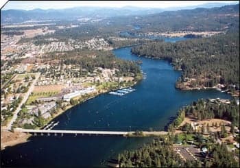
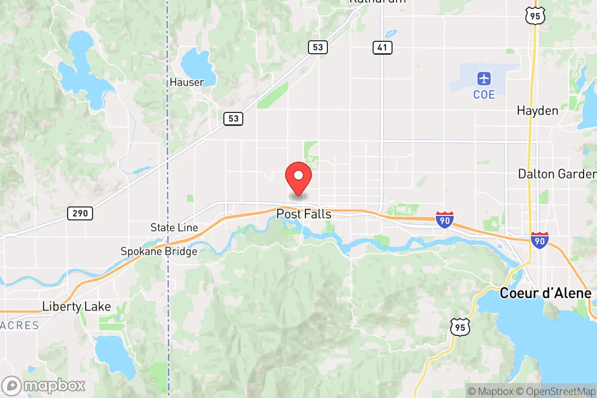
Post Falls, Idaho, sits in a geographic sweet spot that offers genuine strategic depth for those serious about long-term preparedness. Located in Kootenai County along the Idaho-Washington border, this town of roughly 45,000 residents benefits from being far enough from major metropolitan chaos—Spokane is 20 miles west—yet close enough to access critical supply routes and medical infrastructure when things are stable. The real advantage here is the combination of a growing conservative population, a state government that actively pushes back against federal overreach, and a landscape that provides natural barriers and resources for those thinking in terms of decades, not just election cycles.
Geographic position and natural advantages for long-term security
Post Falls is anchored by the Spokane River and the Rathdrum Prairie aquifer, one of the largest and cleanest groundwater sources in the country. This isn't just a nice-to-have—it's a fundamental resilience factor. In a grid-down scenario or during a prolonged drought, having access to a massive, replenishing aquifer within a few feet of the surface is a strategic asset that most of the country simply does not have. The surrounding terrain offers a mix of forested hills, agricultural valleys, and the Coeur d'Alene Mountains to the east, providing multiple layers of natural defensibility. The town itself sits at the intersection of I-90 and US-95, which is a double-edged sword: it's a critical evacuation and supply corridor, but also a potential chokepoint. For a relocator, the key is to understand that Post Falls is not a remote bunker—it's a staging ground. You're close enough to the resources of Coeur d'Alene (10 miles east) and Spokane (20 miles west) to stock up and network, but far enough that you're not in the blast radius of any immediate urban collapse. The local topography, with its ridges and river valleys, offers numerous options for a retreat property that is both accessible and concealed.
Risks, exposures, and proximity to fallout-relevant landmarks
No strategic assessment is honest without addressing the liabilities. Post Falls' proximity to Spokane is the most significant exposure. Spokane is a regional hub with a population over 220,000, a major rail yard, and Fairchild Air Force Base, which houses tanker aircraft and is a logical target in any conflict involving strategic assets. In a mass casualty event or a nuclear exchange, the fallout plume from a strike on Fairchild or the Spokane industrial corridor could drift eastward into Kootenai County depending on wind patterns. Additionally, I-90 is a primary east-west artery; in a crisis, it will become a parking lot of panicked evacuees from Seattle and the Puget Sound region. The 2021 wildfires and the 2020 civil unrest in nearby cities demonstrated that chaos can arrive quickly, even in a place like North Idaho. The area also sits in a seismically active zone—the nearby Newport fault zone and the larger Cascadia subduction zone to the west mean that a major earthquake could disrupt infrastructure for weeks. For the prepper, the calculus is clear: Post Falls offers excellent natural resources and a like-minded community, but you must plan for the reality that you are within a day's drive of several million people who will have the same idea when things go sideways. The solution is not to avoid the area, but to be prepared to secure your perimeter, have multiple egress routes, and store supplies for extended isolation.
Practical resilience for a relocator: food, water, energy, and defensibility
Water is the single most important factor, and Post Falls has it in abundance. The Rathdrum Prairie aquifer is so prolific that many residents draw from private wells with minimal effort. For a relocator, securing a property with a well or direct access to the Spokane River is a non-negotiable priority. The growing season is short—roughly 120 days—but the soil in the surrounding Palouse region is among the most fertile in the world for grains and legumes. Local farmers markets and co-ops are strong, and there is a robust network of homesteaders and small-scale livestock operations. Energy resilience is achievable: the region has good solar potential despite cloudy winters, and many properties are suitable for micro-hydro if you have a creek. Wood heating is standard, with abundant public and private forestland for harvesting. Defensibility varies by neighborhood. The newer subdivisions near I-90 are convenient but offer little tactical advantage; older properties along the river or up in the hills provide natural chokepoints and visibility. The local culture is heavily armed and self-reliant—Kootenai County has one of the highest per-capita firearm ownership rates in the nation, and the sheriff's office has publicly stated it will not enforce federal gun control measures. For a relocator, this means you are joining a community that takes preparedness seriously, but it also means you need to be a good neighbor and contributor, not just a consumer of security. Medical infrastructure is adequate for routine care, with Kootenai Health in Coeur d'Alene offering a Level II trauma center, but for serious events, you'll be relying on Spokane's hospitals—which, again, are a vulnerability in a crisis. Stockpiling trauma kits, antibiotics, and training is essential.
The overall strategic picture for Post Falls is one of high potential with clear-eyed trade-offs. It is not a remote survivalist paradise—it is a growing, politically active community that offers a strong base for those who want to be part of something larger than a solo retreat. The state of Idaho's constitutional carry laws, its resistance to federal land grabs, and its growing network of preparedness-minded churches and civic groups make it one of the few places in the lower 48 where a conservative prepper can live openly without being marginalized. The risks from Spokane, the I-90 corridor, and natural disasters are real, but they are manageable with proper planning. For the single individual or family looking to relocate with a long-term strategic mindset, Post Falls deserves serious consideration—provided you arrive with skills, supplies, and a willingness to integrate into a community that values self-reliance above all else.
* Values derived from national, state, county, city and local statistics and may differ in a specific area. Last updated: 2026-04-19T05:23:42.000Z
Narrative content on this page is AI-generated and may contain mistakes. Verify any details that matter before acting on them.
ReloMaps may earn a commission from affiliate links at no extra cost to you.