Photo: Wikipedia
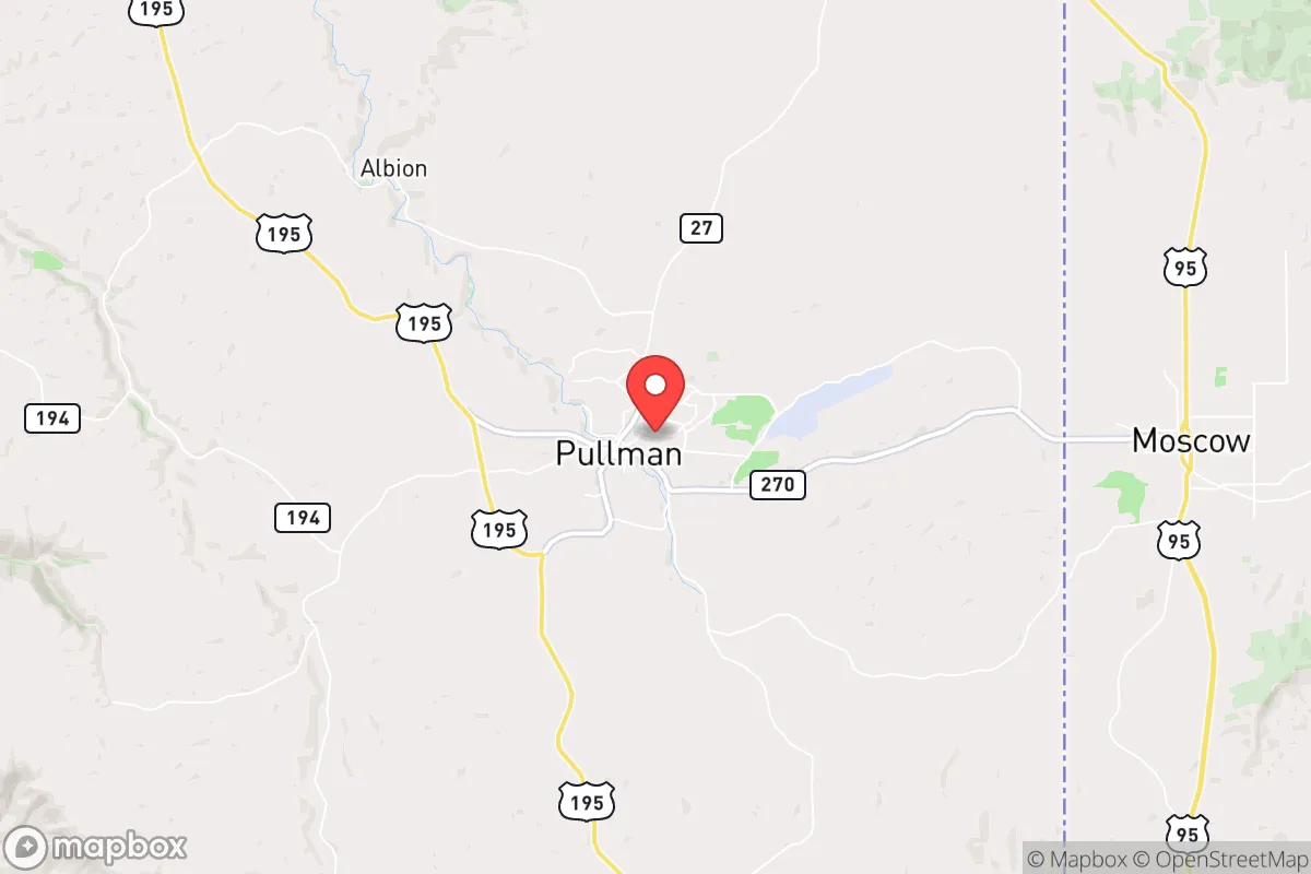
Strategic Assessment of Pullman, WA
Workable tactical position. Some exposure to population density or targets, but generally defensible in a crisis.
What does the Strategic Assessment tell us?
Our Strategic Assessment grades tactical survivability of an area. Major population centers, military targets, fallout zones, natural disasters, and border exposure all drive risk — lower exposure means a more defensible position in a crisis.
This is heavily inspired by Joel Skousen's Strategic Relocation book. Highly recommended you checkout the book ($)What does this tell us?
Our Strategic Assessment grades tactical survivability of an area. Major population centers, military targets, fallout zones, natural disasters, and border exposure all drive risk — lower exposure means a more defensible position in a crisis.
This is heavily inspired by Joel Skousen's Strategic Relocation book. Highly recommended you checkout the book ($)Strategic Pillars

Key Distances
Regional Safe Places
Below is our recommended "safe zones" in Washington and the surrounding area based on our strategic heuristics. For most people, it's unrealistic to live in a “safe zone” full-time due to work, family or other personal reasons. They tend to be more rural. However, many of these areas are perfect for second homes and retreat properties that double as a vacation home or even a short-term rental.


Important Note: For informational purposes only. This does not mean nothing bad ever happens in the green zones. Please use common sense. This is based on public data and modeled with AI. We tried to take a conservative approach but mistakes happen. We update this regularly as new information becomes available.
Solar Generator Recommendations
Backup power matters more here than in safer locations. We've picked three solar generators across budgets and capacity tiers — start with the budget unit if you only need a few essentials, or step up if you want to run a fridge and HVAC for days at a time.

Jackery Portable Power Station Explorer 300
Budget OptionPower on the Go: Weighing only 11 lbs, it's convenient to set up and store with book-sized foldable solar panels

BLUETTI Portable Power Station AC180
Designed for both indoor and outdoor scenarios, AC180 is highly capable as it has a robost capacity and continuous output power.

EF ECOFLOW DELTA Pro Ultra Power Station
Upgraded PickEcoFlow DELTA Pro Ultra is a whole-home energy system designed to grow with your family. Integrated with the Smart Home Panel 2, it scales to meet your evolving energy needs — keeping your home powered, intelligent, and secure through every stage of life.
We earn a commission, at no additional cost to you.
Strategic Assessment Analysis
Pullman, Washington, offers a surprisingly resilient strategic position for those prioritizing self-sufficiency and distance from major population centers, though it carries distinct trade-offs. Nestled in the southeastern corner of the state, this college town of roughly 35,000 sits over 75 miles from Spokane and nearly 300 miles from Seattle, placing it well outside the immediate fallout zones of major metropolitan targets. Its location on the Palouse—a region of rolling wheat fields and low population density—provides natural buffers against the cascading effects of urban collapse, civil unrest, or mass casualty events that would likely cripple larger cities first.
Geographic isolation and natural advantages for long-term security
Pullman’s primary strategic asset is its geographic isolation. The city is surrounded by vast agricultural land—the Palouse produces a significant portion of the nation’s wheat, barley, and legumes—which means local food production is not just possible but already the dominant industry. The region’s low population density (about 12 people per square mile in Whitman County) reduces competition for resources during a crisis and limits the risk of rapid disease spread or mob violence. The nearby Snake and Clearwater Rivers provide reliable freshwater sources, and the area’s moderate climate (cold winters, dry summers) supports year-round gardening with proper planning. For a relocator, this means you’re not dependent on fragile supply chains; the land itself can sustain you if you’re prepared to work it. The lack of major interstate highways or rail hubs also means Pullman is unlikely to become a refugee destination—most evacuees from the West Coast would bottleneck in Spokane or the Tri-Cities long before reaching the Palouse.
Risks, exposures, and proximity to potential fallout-relevant landmarks
No location is without vulnerabilities, and Pullman has several that demand attention. The most obvious is its proximity to the Hanford Nuclear Reservation, roughly 120 miles southwest. While 120 miles provides significant distance from a direct blast, prevailing winds could carry fallout across the Palouse in a worst-case scenario. The Hanford site contains 56 million gallons of radioactive waste, making it a prime target for sabotage or accidental release during a national crisis. Additionally, Pullman is home to Washington State University (WSU), a major research institution with a student population of over 20,000. In a collapse scenario, a university town can become a liability—students may lack survival skills, and the institution itself could attract federal attention or become a focal point for unrest. The city’s reliance on a single major employer (WSU) also means economic stability is fragile; if the university shuts down, the local economy would crater. Finally, the region’s agricultural dominance means heavy reliance on diesel-powered equipment and chemical fertilizers—both of which could become scarce in a prolonged disruption.
Practical resilience for a relocator: food, water, energy, and defensibility
For those serious about prepping, Pullman offers a mixed but workable picture. Food security is excellent: the Palouse is one of the most productive agricultural regions in the country, and local farmers’ markets, co-ops, and direct-from-farm purchasing are well-established. You can realistically stockpile grains, legumes, and dried goods from local sources without relying on cross-country shipping. Water is abundant but requires infrastructure—the Snake River and local aquifers are reliable, but you’ll need a well, filtration system, or rainwater catchment to be independent of municipal supply. Energy is a weak point: the grid is served by Avista Utilities, which relies on hydroelectric power from the Columbia River system. While hydro is more resilient than coal or gas, a major earthquake or cyberattack on the Pacific Northwest grid could knock out power for weeks. Solar is viable (the region gets 200+ sunny days per year), but winter cloud cover reduces output significantly. Defensibility is moderate: Pullman’s layout—a compact town on a hill with limited road access—makes it easier to secure than a sprawling suburb, but it’s not a natural fortress. The surrounding farmland offers open sightlines, which is good for early warning but bad for concealment. A better defensive setup would be a rural homestead 10–20 miles outside town, where you can control access and maintain a lower profile. The local gun culture is strong (Washington is a shall-issue state for concealed carry, and rural Whitman County is generally pro-Second Amendment), so you won’t face the same hostility to firearms that you might in King County.
The overall strategic picture for a conservative relocator
Pullman presents a viable but imperfect option for those seeking a strategic relocation. Its strengths—agricultural abundance, low population density, distance from major targets, and a conservative-leaning rural culture—align well with a prepper mindset. Its weaknesses—proximity to Hanford, dependence on a university economy, and grid vulnerability—require serious mitigation planning. For a single individual or family willing to invest in off-grid water and energy systems, and to establish relationships with local farmers and tradespeople, Pullman offers a solid foundation. But it’s not a bug-out location; it’s a live-in community where you’ll need to integrate and contribute. The political climate in Whitman County is mixed—the town itself leans left due to the university, but the surrounding county is reliably conservative. If you can navigate that tension and build a network, Pullman can serve as a long-term base for weathering the storms ahead. Just don’t expect to disappear entirely; the Palouse is beautiful, but it’s also a place where everyone knows your business—and that’s exactly the kind of community awareness that keeps you safe when things go sideways.
* Values derived from national, state, county, city and local statistics and may differ in a specific area. Last updated: 2026-05-03T04:52:18.000Z
Narrative content on this page is AI-generated and may contain mistakes. Verify any details that matter before acting on them.
ReloMaps may earn a commission from affiliate links at no extra cost to you.