
Photo: Wikipedia
Strategic Assessment of Rancho Cucamonga, CA
Multiple tactical vulnerabilities. Population density, target proximity, or disaster risk are likely compounding. A retreat property and exit planning is required.
What does the Strategic Assessment tell us?
Our Strategic Assessment grades tactical survivability of an area. Major population centers, military targets, fallout zones, natural disasters, and border exposure all drive risk — lower exposure means a more defensible position in a crisis.
This is heavily inspired by Joel Skousen's Strategic Relocation book. Highly recommended you checkout the book ($)What does this tell us?
Our Strategic Assessment grades tactical survivability of an area. Major population centers, military targets, fallout zones, natural disasters, and border exposure all drive risk — lower exposure means a more defensible position in a crisis.
This is heavily inspired by Joel Skousen's Strategic Relocation book. Highly recommended you checkout the book ($)Strategic Pillars

Key Distances
Regional Safe Places
Below is our recommended "safe zones" in California and the surrounding area based on our strategic heuristics. For most people, it's unrealistic to live in a “safe zone” full-time due to work, family or other personal reasons. They tend to be more rural. However, many of these areas are perfect for second homes and retreat properties that double as a vacation home or even a short-term rental.


Important Note: For informational purposes only. This does not mean nothing bad ever happens in the green zones. Please use common sense. This is based on public data and modeled with AI. We tried to take a conservative approach but mistakes happen. We update this regularly as new information becomes available.
Solar Generator Recommendations
Backup power matters more here than in safer locations. We've picked three solar generators across budgets and capacity tiers — start with the budget unit if you only need a few essentials, or step up if you want to run a fridge and HVAC for days at a time.

Jackery Portable Power Station Explorer 300
Budget OptionPower on the Go: Weighing only 11 lbs, it's convenient to set up and store with book-sized foldable solar panels

BLUETTI Portable Power Station AC180
Designed for both indoor and outdoor scenarios, AC180 is highly capable as it has a robost capacity and continuous output power.

EF ECOFLOW DELTA Pro Ultra Power Station
Upgraded PickEcoFlow DELTA Pro Ultra is a whole-home energy system designed to grow with your family. Integrated with the Smart Home Panel 2, it scales to meet your evolving energy needs — keeping your home powered, intelligent, and secure through every stage of life.
We earn a commission, at no additional cost to you.
Strategic Assessment Analysis
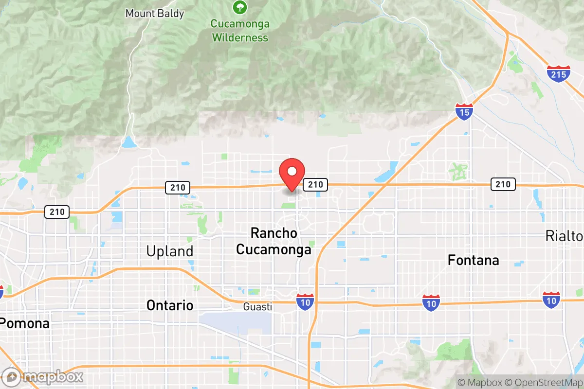
Rancho Cucamonga, California, sits in a precarious but potentially defensible position at the base of the San Gabriel Mountains, roughly 35 miles east of downtown Los Angeles. For a relocator with a survivalist mindset, this location offers a mix of strategic advantages and glaring vulnerabilities: it’s close enough to major urban centers to benefit from their infrastructure, yet far enough to avoid the immediate blast radius of a worst-case scenario. The city’s elevation—around 1,200 feet—provides some natural drainage and cooler temperatures than the Inland Empire valleys, but its real value lies in its access to mountain escape routes and the relative stability of San Bernardino County’s governance compared to Los Angeles County’s chaos. However, the proximity to the San Andreas Fault, the region’s dense population, and its role as a logistics hub for Southern California make it a high-risk, high-reward proposition for anyone serious about long-term preparedness.
Geographic position and natural advantages for strategic relocation
Rancho Cucamonga’s geography is its strongest card. The city sits at the mouth of Cucamonga Canyon, a natural corridor into the Angeles National Forest, which provides immediate access to high ground, water sources, and potential bug-out locations. The San Gabriel Mountains to the north act as a physical barrier against urban sprawl, offering defensible terrain and a potential retreat zone if civil unrest or a mass casualty event hits the valley floor. The area’s Mediterranean climate—hot, dry summers and mild, wet winters—means you’re not fighting extreme cold or snow in most scenarios, which simplifies food storage and energy needs. The Santa Ana River watershed runs through the region, and while it’s not a reliable year-round surface source in the city itself, the mountain canyons hold seasonal streams and springs that a prepared relocator could tap with proper filtration. The city’s grid layout, with major arteries like Foothill Boulevard and the 210 Freeway, gives you multiple egress routes east toward the Mojave Desert or north into the mountains, though these roads will clog fast in a crisis. For a conservative-leaning prepper, the natural advantages here are real but require active management—you’re not in a remote bunker, but you’re not trapped in a concrete jungle either.
Risks, exposures, and proximity to fallout-relevant landmarks
The downsides are significant and demand honest assessment. Rancho Cucamonga is within 10 miles of the San Andreas Fault, which runs through the Cajon Pass to the northeast. A major earthquake—say, a 7.8 or higher—would devastate the region’s infrastructure, including water pipelines, power grids, and the 15 Freeway, which is a critical north-south artery. The city’s proximity to Ontario International Airport (about 5 miles south) and the Port of Los Angeles/Long Beach complex (roughly 50 miles west) makes it a potential secondary target in a conflict scenario—think supply chain disruptions, not direct strikes, but still a vulnerability. The San Onofre Nuclear Generating Station is about 60 miles south, and while it’s decommissioned, the spent fuel storage there remains a risk. More immediately, the March Air Reserve Base in Riverside (20 miles southeast) and the Naval Weapons Station Seal Beach (40 miles southwest) are military assets that could become focal points in a crisis. The city’s population density—roughly 175,000 people in 40 square miles—means you’re surrounded by neighbors who may not be prepared, leading to potential panic and resource competition. The 210 Freeway and 15 Freeway interchanges are notorious choke points; a single accident or road closure could trap you in the valley. For a survivalist, these exposures mean you need a solid plan for self-sufficiency, not just a bug-out bag.
Practical resilience for a relocator: food, water, energy, and defensibility
On the ground, Rancho Cucamonga offers a mixed bag for practical resilience. Water is the biggest concern: the city relies on the State Water Project and local groundwater from the Rialto-Colton Basin, but a multi-day power outage would shut down pumps. You’d need to store at least 50 gallons per person for a two-week scenario, and have a Berkey or similar filter for mountain stream water. Food is easier: the city has multiple grocery stores (Stater Bros., WinCo, Costco) within a 10-minute drive, but these will empty in hours during a panic. A better bet is to establish relationships with local farms in the Chino Valley (15 minutes south) or the Upland Farmers Market for bulk produce and eggs. Energy is a weak point: Southern California Edison’s grid is aging and prone to Public Safety Power Shutoffs during high winds, which happen annually. Solar panels with battery backup (like Tesla Powerwall) are a must, and a generator for well pumps or refrigeration is non-negotiable. Defensibility is tricky: most homes are in suburban subdivisions with open floor plans and large windows, making them hard to secure. Look for properties on the north side of the city, near the foothills, where lots are larger and neighbors are farther apart—areas like Deer Creek or Alta Loma offer better sightlines and escape routes. The San Bernardino County Sheriff’s Department has a decent response time (around 10 minutes for priority calls), but in a mass casualty event, you’re on your own. A community of like-minded preppers exists in the area, often linked through local gun clubs or the Inland Empire Preparedness Meetup, which can be a force multiplier for shared resources and security.
The overall strategic picture for Rancho Cucamonga is one of calculated risk. It’s not a remote survivalist paradise—you’re still in the shadow of Los Angeles, with all the fallout dangers that implies—but it’s not a death trap either. The city’s access to mountain terrain, multiple egress routes, and a relatively stable local government (compared to LA County’s dysfunction) gives you a fighting chance if you’re disciplined about preparation. The key is to treat it as a base camp, not a final destination: stockpile supplies, harden your home, and have a bug-out plan for the San Gabriel Mountains or the Mojave Desert. For a conservative-leaning relocator who wants to stay close to job opportunities in the Inland Empire while maintaining a prepper mindset, Rancho Cucamonga is a viable option—but only if you’re willing to invest in the infrastructure and community ties that make resilience possible. The state of the country may be uncertain, but here, you can at least control your own perimeter.
* Values derived from national, state, county, city and local statistics and may differ in a specific area. Last updated: 2026-04-24T11:02:32.000Z
Narrative content on this page is AI-generated and may contain mistakes. Verify any details that matter before acting on them.
ReloMaps may earn a commission from affiliate links at no extra cost to you.