
Photo: Wikipedia
Strategic Assessment of Ravenswood, WV
Meaningful friction. Expect exposure to either population pressure, blast zones, or natural disaster risk. Consider buying a retreat property.
What does the Strategic Assessment tell us?
Our Strategic Assessment grades tactical survivability of an area. Major population centers, military targets, fallout zones, natural disasters, and border exposure all drive risk — lower exposure means a more defensible position in a crisis.
This is heavily inspired by Joel Skousen's Strategic Relocation book. Highly recommended you checkout the book ($)What does this tell us?
Our Strategic Assessment grades tactical survivability of an area. Major population centers, military targets, fallout zones, natural disasters, and border exposure all drive risk — lower exposure means a more defensible position in a crisis.
This is heavily inspired by Joel Skousen's Strategic Relocation book. Highly recommended you checkout the book ($)Strategic Pillars

Key Distances
Regional Safe Places
Below is our recommended "safe zones" in West Virginia and the surrounding area based on our strategic heuristics. For most people, it's unrealistic to live in a “safe zone” full-time due to work, family or other personal reasons. They tend to be more rural. However, many of these areas are perfect for second homes and retreat properties that double as a vacation home or even a short-term rental.


Important Note: For informational purposes only. This does not mean nothing bad ever happens in the green zones. Please use common sense. This is based on public data and modeled with AI. We tried to take a conservative approach but mistakes happen. We update this regularly as new information becomes available.
Solar Generator Recommendations
Backup power matters more here than in safer locations. We've picked three solar generators across budgets and capacity tiers — start with the budget unit if you only need a few essentials, or step up if you want to run a fridge and HVAC for days at a time.

Jackery Portable Power Station Explorer 300
Budget OptionPower on the Go: Weighing only 11 lbs, it's convenient to set up and store with book-sized foldable solar panels

BLUETTI Portable Power Station AC180
Designed for both indoor and outdoor scenarios, AC180 is highly capable as it has a robost capacity and continuous output power.

EF ECOFLOW DELTA Pro Ultra Power Station
Upgraded PickEcoFlow DELTA Pro Ultra is a whole-home energy system designed to grow with your family. Integrated with the Smart Home Panel 2, it scales to meet your evolving energy needs — keeping your home powered, intelligent, and secure through every stage of life.
We earn a commission, at no additional cost to you.
Strategic Assessment Analysis
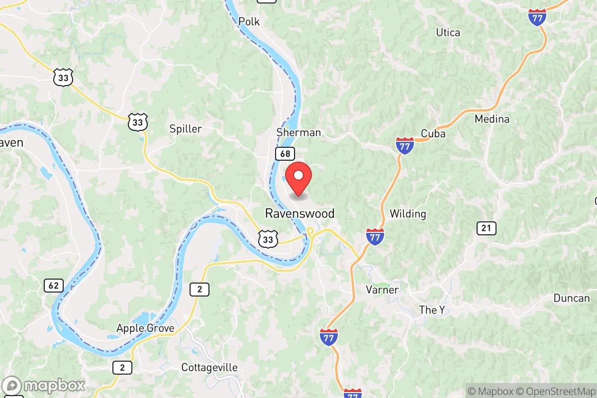
Ravenswood, West Virginia, offers a surprisingly resilient strategic position for those prioritizing long-term preparedness and self-sufficiency. Nestled along the Ohio River in Jackson County, this small town of roughly 3,800 people sits far enough from major metropolitan chaos to avoid the worst of civic unrest, yet remains connected enough for supply runs and information flow. Its location—roughly 45 minutes from Charleston, 90 minutes from Columbus, and 2 hours from Pittsburgh—places it in a sweet spot: close enough to monitor regional instability, but distant enough to avoid being a primary target or evacuation route. For the prepper or survivalist looking at the deteriorating national picture, Ravenswood’s combination of river access, low population density, and Appalachian geography makes it a serious candidate for a relocation base.
Geographic position and natural advantages for long-term survival
Ravenswood sits on a flat terrace of the Ohio River, flanked by the rolling hills of the Appalachian foothills. This topography provides natural defensibility: the river acts as a barrier to the west, while the wooded ridges to the east offer observation points, escape routes, and cover. The area is part of the Western Allegheny Plateau, meaning it has abundant hardwood forests for fuel, construction, and foraging. The Ohio River itself is a double-edged sword—it’s a major transportation artery for commerce and potential evacuation, but also a source of water, fish, and navigation. The town’s elevation (roughly 600 feet above sea level) keeps it above typical flood zones, though the river can rise. The surrounding Jackson County is heavily rural, with a population density of about 50 people per square mile, meaning you’re not boxed in by neighbors. The climate is temperate: hot, humid summers and cold winters with moderate snowfall, which supports year-round gardening and hunting. For a relocator, the key advantage is the ability to live off the land without extreme weather killing your crops or freezing your water lines. The area’s natural springs and creeks are plentiful, though you’ll want to test and treat any surface water. The hills also provide natural radio shadowing, which can be a plus for OPSEC (operational security) if you’re running comms gear.
Risks, exposures, and proximity to fallout-relevant landmarks
No strategic assessment is honest without addressing the downsides. Ravenswood’s primary risk is its proximity to the Ohio River Valley’s industrial and energy infrastructure. Roughly 20 miles upstream is the Mountaineer Power Plant (a coal-fired facility) and the Pleasants Power Station (natural gas). While not nuclear, these are potential targets for sabotage or accident during civil unrest. More concerning is the Willow Island Nuclear Power Plant (decommissioned but still holding spent fuel) about 30 miles north in West Virginia. A catastrophic event there—whether from attack or decay—could put Ravenswood in a downwind fallout plume depending on prevailing westerlies. The Morgantown Industrial Park and DuPont Washington Works (chemical plants) are about 60 miles northeast, adding a chemical release risk. On the human threat side, Ravenswood is within a 2-hour drive of Columbus, Ohio (population 900,000) and Charleston, West Virginia (population 50,000). During a major collapse or mass casualty event, these cities could become source zones for refugees, looters, or organized gangs moving along the I-77 and US-35 corridors. The town itself has a single police department with fewer than a dozen officers, and the Jackson County Sheriff’s Office is stretched thin. For a relocator, this means you cannot rely on law enforcement for protection—you are the first and last line of defense. The local hospital (Jackson General) is a small critical-access facility; major trauma means a 45-minute drive to Charleston. Stockpile medical supplies and train in basic trauma care.
Practical resilience for a relocator: food, water, energy, and defensibility
For the prepper, Ravenswood offers several concrete advantages. Water: The Ohio River is a reliable year-round source, but you’ll need filtration (Berkey, Sawyer, or a DIY sand filter) and chemical treatment. The town’s municipal water comes from the river, so a grid-down scenario means no tap water. Digging a well on your property is the gold standard—the water table here is shallow (30-60 feet) in most areas. Food: The growing season runs April to October, with fertile river-bottom soil. You can raise corn, beans, squash, and root vegetables. Deer, turkey, and small game are abundant in the surrounding national forests (Wayne National Forest is 20 minutes north in Ohio). Fishing in the Ohio River is decent for catfish, bass, and crappie, but check for heavy metal contamination from industrial runoff. Energy: The area gets about 4.5 peak sun hours per day in winter, so solar is viable but you’ll need battery storage. Wood heat is the most practical backup—the hills are thick with oak, hickory, and maple. Propane delivery is common in the region, so a buried 500-gallon tank with a generator hookup is a solid investment. Defensibility: Ravenswood’s layout is a classic river town—a main street (Washington Street) running parallel to the river, with residential neighborhoods climbing the hills to the east. The best properties for security are those on the eastern ridges with a single access road and clear sightlines to the valley below. Avoid properties directly on the river floodplain (below 580 feet elevation) and those within a mile of the US-35 bridge, which is a chokepoint for traffic from Ohio. The local gun culture is strong—Jackson County has a high rate of firearm ownership and a pro-2A sheriff’s office. You can expect to be able to carry openly or concealed without hassle, but keep a low profile until you’ve built trust with neighbors.
The overall strategic picture for Ravenswood is cautiously optimistic for the prepared relocator. It’s not a hardened bunker location like the Montana Rockies, but it offers a realistic balance of resources, isolation, and access. The biggest threats are the industrial and population centers within a 100-mile radius, which could become sources of fallout (literal and figurative) during a national crisis. However, the town’s small size, river barrier, and hilltop defensibility give you a fighting chance to ride out the first wave of chaos. The local community is predominantly conservative, self-reliant, and suspicious of outsiders—which is both a protection and a challenge. You’ll need to integrate slowly, help with community projects, and demonstrate that you’re not a threat. If you can secure a property with well water, wood heat, and a garden plot, and you’re willing to invest in solar and a solid security perimeter, Ravenswood can serve as a viable long-term base for weathering the storm. Just don’t expect to be left completely alone—the Ohio River corridor is a strategic chokepoint, and if things go truly sideways, you’ll have to defend what you’ve built. Plan accordingly.
* Values derived from national, state, county, city and local statistics and may differ in a specific area. Last updated: 2026-05-02T00:54:50.000Z
Narrative content on this page is AI-generated and may contain mistakes. Verify any details that matter before acting on them.
ReloMaps may earn a commission from affiliate links at no extra cost to you.