
Photo: Wikipedia
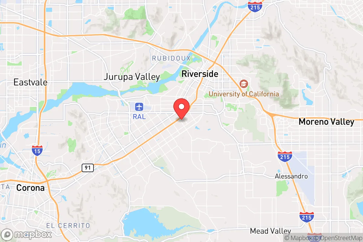
Strategic Assessment of Riverside, CA
Multiple tactical vulnerabilities. Population density, target proximity, or disaster risk are likely compounding. A retreat property and exit planning is required.
What does the Strategic Assessment tell us?
Our Strategic Assessment grades tactical survivability of an area. Major population centers, military targets, fallout zones, natural disasters, and border exposure all drive risk — lower exposure means a more defensible position in a crisis.
This is heavily inspired by Joel Skousen's Strategic Relocation book. Highly recommended you checkout the book ($)What does this tell us?
Our Strategic Assessment grades tactical survivability of an area. Major population centers, military targets, fallout zones, natural disasters, and border exposure all drive risk — lower exposure means a more defensible position in a crisis.
This is heavily inspired by Joel Skousen's Strategic Relocation book. Highly recommended you checkout the book ($)Strategic Pillars

Key Distances
Regional Safe Places
Below is our recommended "safe zones" in California and the surrounding area based on our strategic heuristics. For most people, it's unrealistic to live in a “safe zone” full-time due to work, family or other personal reasons. They tend to be more rural. However, many of these areas are perfect for second homes and retreat properties that double as a vacation home or even a short-term rental.


Important Note: For informational purposes only. This does not mean nothing bad ever happens in the green zones. Please use common sense. This is based on public data and modeled with AI. We tried to take a conservative approach but mistakes happen. We update this regularly as new information becomes available.
Solar Generator Recommendations
Backup power matters more here than in safer locations. We've picked three solar generators across budgets and capacity tiers — start with the budget unit if you only need a few essentials, or step up if you want to run a fridge and HVAC for days at a time.

Jackery Portable Power Station Explorer 300
Budget OptionPower on the Go: Weighing only 11 lbs, it's convenient to set up and store with book-sized foldable solar panels

BLUETTI Portable Power Station AC180
Designed for both indoor and outdoor scenarios, AC180 is highly capable as it has a robost capacity and continuous output power.

EF ECOFLOW DELTA Pro Ultra Power Station
Upgraded PickEcoFlow DELTA Pro Ultra is a whole-home energy system designed to grow with your family. Integrated with the Smart Home Panel 2, it scales to meet your evolving energy needs — keeping your home powered, intelligent, and secure through every stage of life.
We earn a commission, at no additional cost to you.
Strategic Assessment Analysis
Riverside, California, sits in a precarious strategic position that demands a clear-eyed assessment for anyone serious about long-term preparedness. While the city itself offers some natural advantages in terms of climate and water access, its location within the Inland Empire places it dangerously close to major population centers, critical infrastructure, and potential fallout zones that could become liabilities in a crisis. For a conservative-minded relocator weighing resilience against risk, Riverside presents a mixed picture—one where the benefits of a semi-arid environment and regional food production are offset by proximity to Los Angeles, San Diego, and the San Andreas Fault system.
Geographic position and natural advantages for long-term survival
Riverside’s location at the western edge of the Sonoran Desert, within the Santa Ana River watershed, gives it a few genuine strategic assets. The region’s Mediterranean climate means year-round growing seasons are possible with proper water management, and the surrounding agricultural areas—particularly the Coachella and Imperial Valleys to the east—are among the most productive in the nation. For a prepper, this translates into relatively short supply lines for fresh food, even if national distribution networks falter. The city sits at an elevation of roughly 800 feet, which provides some natural cooling and reduces the risk of coastal flooding, though it is not immune to flash flooding from the Santa Ana River. The nearby San Bernardino and San Jacinto Mountains offer potential retreat zones with higher elevation, cooler temperatures, and forest resources, all within a 30- to 60-minute drive. Groundwater access is a mixed bag: the Riverside Basin has some local aquifers, but overdraft and contamination from decades of agriculture and urban runoff mean that well water quality varies significantly by neighborhood. For a relocator, the key natural advantage here is the ability to tap into a regional food hub, but only if you secure a property with a reliable, tested well and a defensible position away from floodplains.
Risks, exposures, and proximity to fallout-relevant landmarks
The most glaring vulnerability for Riverside is its proximity to high-value, high-risk targets. Riverside lies roughly 50 miles east of Los Angeles, 80 miles north of San Diego, and within 20 miles of March Air Reserve Base—a major military installation that could be a primary target in any conflict involving the United States. The city is also within 100 miles of the San Onofre Nuclear Generating Station (now decommissioned but still storing spent fuel) and the Diablo Canyon Power Plant, though prevailing winds generally blow west to east, meaning fallout from a coastal incident would likely move inland toward Riverside. The San Andreas Fault runs just 30 miles to the northeast, and a major earthquake—the so-called "Big One"—would devastate infrastructure across Southern California, including the aqueducts that supply Riverside’s imported water. Over 60% of Riverside’s water comes from the State Water Project and the Colorado River Aqueduct, both of which cross the fault line. A rupture could cut off water for weeks or months. Additionally, the city’s location along Interstate 215 and State Route 91 means it would be a chokepoint for mass evacuation from the coast, potentially turning Riverside into a gridlocked, resource-depleted zone during a crisis. For a prepper, the risk of being caught in a cascading failure—earthquake, followed by water loss, followed by civil unrest from coastal refugees—is very real.
Practical resilience for a relocator: food, water, energy, and defensibility
On the practical side, Riverside offers some workable options for a prepared individual or family, but they require deliberate planning and investment. Local food production is viable—the city’s climate supports citrus, avocados, and vegetables, and there are active farmers’ markets and community gardens—but suburban HOA restrictions can limit backyard gardening or livestock. Water storage is non-negotiable: a minimum of 55 gallons per person for a two-week supply is a baseline, but given the risk of aqueduct failure, a 1,000-gallon tank with a rainwater catchment system is more realistic. Electricity is relatively reliable in normal times, but the grid is vulnerable to wildfire shutoffs and earthquake damage; solar panels with battery backup are a wise investment, as Riverside averages over 280 sunny days per year. Defensibility is a challenge. Most residential neighborhoods are flat, with open street grids and minimal natural barriers. The better options for a security-conscious relocator are the foothill communities like Woodcrest, Rubidoux, or the Box Springs area, where larger lots, hillside positions, and limited access points provide some tactical advantage. Crime rates in Riverside are moderate—the city’s violent crime rate is roughly 30% higher than the national average, with property crime a persistent issue—so a home security system, reinforced doors, and a neighborhood watch network are practical steps. For energy, natural gas is common, but a backup propane tank and a wood-burning stove or fireplace add redundancy for cooking and heating during grid-down scenarios.
Overall, Riverside is a location that demands a clear-eyed, risk-adjusted approach. It is not a bug-out destination—it is too close to too many people and too many targets for that. But for someone who already lives in Southern California and wants to stay within driving distance of work or family, it offers a workable base if you are willing to invest in water independence, food production, and home security. The strategic picture is one of managed risk: you trade the immediate dangers of coastal urban centers for the slower-burning vulnerabilities of inland infrastructure dependence. If you can secure a property with a well, solar, and defensible terrain in the eastern or northern outskirts, Riverside becomes a viable long-term hold. If you are looking for a true retreat far from population centers and strategic targets, look further east toward the Mojave or north toward the Sierra Nevada foothills. For the prepared relocator who understands the trade-offs, Riverside is a calculated compromise—not a sanctuary, but a survivable position with options.
* Values derived from national, state, county, city and local statistics and may differ in a specific area. Last updated: 2026-04-29T21:30:54.000Z
Narrative content on this page is AI-generated and may contain mistakes. Verify any details that matter before acting on them.
ReloMaps may earn a commission from affiliate links at no extra cost to you.