Photo: Wikipedia
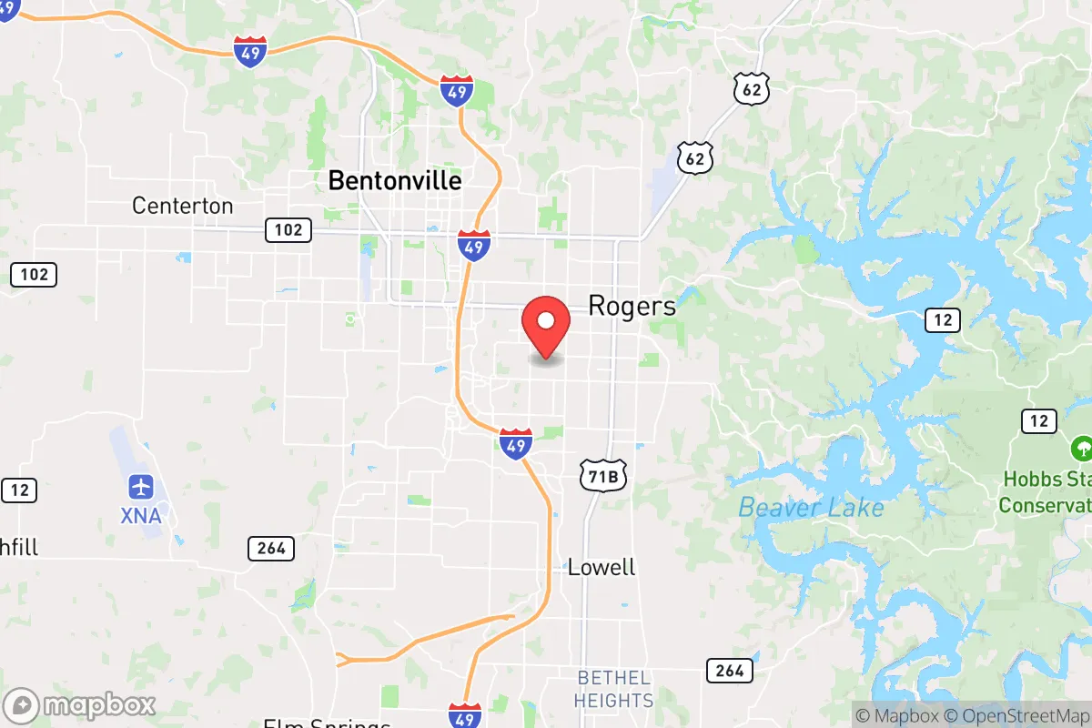
Strategic Assessment of Rogers, AR
Workable tactical position. Some exposure to population density or targets, but generally defensible in a crisis.
What does the Strategic Assessment tell us?
Our Strategic Assessment grades tactical survivability of an area. Major population centers, military targets, fallout zones, natural disasters, and border exposure all drive risk — lower exposure means a more defensible position in a crisis.
This is heavily inspired by Joel Skousen's Strategic Relocation book. Highly recommended you checkout the book ($)What does this tell us?
Our Strategic Assessment grades tactical survivability of an area. Major population centers, military targets, fallout zones, natural disasters, and border exposure all drive risk — lower exposure means a more defensible position in a crisis.
This is heavily inspired by Joel Skousen's Strategic Relocation book. Highly recommended you checkout the book ($)Strategic Pillars

Key Distances
Regional Safe Places
Below is our recommended "safe zones" in Arkansas and the surrounding area based on our strategic heuristics. For most people, it's unrealistic to live in a “safe zone” full-time due to work, family or other personal reasons. They tend to be more rural. However, many of these areas are perfect for second homes and retreat properties that double as a vacation home or even a short-term rental.


Important Note: For informational purposes only. This does not mean nothing bad ever happens in the green zones. Please use common sense. This is based on public data and modeled with AI. We tried to take a conservative approach but mistakes happen. We update this regularly as new information becomes available.
Solar Generator Recommendations
Backup power matters more here than in safer locations. We've picked three solar generators across budgets and capacity tiers — start with the budget unit if you only need a few essentials, or step up if you want to run a fridge and HVAC for days at a time.

Jackery Portable Power Station Explorer 300
Budget OptionPower on the Go: Weighing only 11 lbs, it's convenient to set up and store with book-sized foldable solar panels

BLUETTI Portable Power Station AC180
Designed for both indoor and outdoor scenarios, AC180 is highly capable as it has a robost capacity and continuous output power.

EF ECOFLOW DELTA Pro Ultra Power Station
Upgraded PickEcoFlow DELTA Pro Ultra is a whole-home energy system designed to grow with your family. Integrated with the Smart Home Panel 2, it scales to meet your evolving energy needs — keeping your home powered, intelligent, and secure through every stage of life.
We earn a commission, at no additional cost to you.
Strategic Assessment Analysis
Rogers, Arkansas, sits in a sweet spot that few relocation analysts fully appreciate: close enough to the economic engine of Northwest Arkansas to thrive, but far enough from the primary blast zones and population chokepoints that make larger metros a liability in a crisis. The city’s position within the Ozark foothills offers natural terrain advantages—elevation changes, dense forest cover, and a network of rural backroads that make it genuinely defensible against the kind of civil disorder that increasingly plagues America’s coastal megacities. For a conservative-leaning individual or family thinking about where to plant roots when the system wobbles, Rogers deserves a hard look, not because it’s perfect, but because it checks more boxes than most places in the continental US.
Geographic position and natural advantages for long-term security
Rogers anchors the western edge of the rapidly growing Northwest Arkansas corridor, but its real value lies in what surrounds it. The city sits at the southern edge of the Ozark Plateau, where the terrain transitions from flat agricultural land to rolling, wooded hills with real elevation gain—think 1,200 to 1,500 feet in the immediate vicinity, with the Boston Mountains rising to over 2,000 feet just south of town. That topography matters for more than scenery. It creates natural chokepoints on the major highways—Interstate 49 runs north-south through Rogers, but the secondary roads (Arkansas 12, 94, and 264) wind through valleys that can be monitored or blocked with minimal effort. The area is also outside the 50-mile radius of any major military or nuclear target, which is a significant advantage over places like Little Rock, Fort Smith, or even Fayetteville. The nearest strategic infrastructure that might draw a first-strike or secondary fallout pattern is the Tyson Foods headquarters in Springdale (about 15 miles south) and the Walmart home office in Bentonville (about 8 miles north). Neither is a primary target, but both are large corporate campuses that could become secondary objectives in a collapse scenario. The Beaver Lake reservoir, which supplies Rogers’ drinking water, sits just 10 miles east and is fed by the White River—a reliable, gravity-fed water source that doesn’t depend on electric pumps for distribution in the immediate area.
Risks, exposures, and proximity to fallout-relevant landmarks
No place is immune, and Rogers has its own set of vulnerabilities that a serious prepper needs to account for. The most obvious is the population density of the entire Northwest Arkansas corridor, which now exceeds 570,000 people across Benton and Washington counties. That’s a lot of mouths to feed if the supply chain breaks, and a lot of potential for civil unrest if the grocery stores go empty for more than a week. The corridor is also bisected by Interstate 49, a major north-south artery that connects to Joplin, Missouri (about 75 miles north) and Fort Smith (about 60 miles south). In a mass evacuation event, that highway becomes a liability—a funnel for desperate people moving through the area. The proximity to the Walmart home office in Bentonville is a double-edged sword. On one hand, it means the region has an outsized logistics and distribution infrastructure, including multiple massive warehouses and a private fleet of trucks. On the other hand, that infrastructure makes the area a potential target for organized looting or even state-level seizure in a prolonged crisis. The nearest military installation is the Arkansas Army National Guard’s Camp Robinson in North Little Rock, about 160 miles southeast—close enough to project force into the region if martial law is declared, but far enough that Rogers won’t be the first place they secure. There are no nuclear power plants within 150 miles, and the nearest major chemical storage facilities are along the Arkansas River near Fort Smith, about 60 miles south. Fallout risk from a limited nuclear exchange is low, but not zero—the region’s prevailing winds come from the southwest, which means any strike on the Dallas-Fort Worth metroplex (about 300 miles southwest) could deposit light fallout in the area within 12-18 hours.
Practical resilience for a relocator: food, water, energy, and defensibility
For someone serious about self-sufficiency, Rogers offers a surprisingly workable baseline. The city’s water supply comes from Beaver Lake, a 28,000-acre reservoir managed by the U.S. Army Corps of Engineers, and the treatment plant has backup generators. But the real play is the abundance of private wells and springs in the surrounding rural areas—anyone buying property outside the city limits (say, east of Highway 12 or south of Rogers toward Lowell) can tap into groundwater that’s generally clean and shallow, with typical well depths of 100 to 300 feet. The growing season runs from April to October, and the soil in the river bottoms is rich enough for serious gardening. The Ozarks are also one of the few regions in the lower 48 where you can realistically hunt for protein year-round—white-tailed deer, wild turkey, and feral hogs are abundant, and the Arkansas Game and Fish Commission maintains a liberal bag limit. For energy, the region is served by Southwestern Electric Power Company (SWEPCO), which relies on a mix of natural gas, coal, and a small amount of wind. Grid reliability is average for the South—expect outages during ice storms and summer thunderstorms—but solar potential is decent, with about 210 sunny days per year, and the terrain allows for off-grid setups without drawing attention. Defensibility is where Rogers really shines. The city itself is laid out in a grid, but the surrounding countryside is a maze of narrow, winding roads that dead-end into hollows and ridges. A small group with basic fieldcraft could effectively deny access to a much larger force. The local culture is still heavily rural and gun-friendly—Benton County has a concealed carry rate well above the national average, and the sheriff’s office is known for a pro-Second Amendment stance. That’s not a guarantee of safety, but it’s a strong signal that the local population won’t be passive victims in a breakdown.
The overall strategic picture for Rogers is cautiously optimistic, but only for those who come in with eyes open. It’s not a remote survivalist retreat—it’s a mid-sized city in a growing region with all the attendant risks of population density and infrastructure dependency. But for a conservative family that wants to maintain a normal life while building real resilience, the math works. The terrain buys you time. The water supply buys you options. The local culture buys you allies. The biggest threat isn’t the location itself—it’s the complacency that comes with living in a place that feels safe. If you move to Rogers, treat it as a base of operations, not a fortress. Build your network, stock your supplies, learn the back roads, and keep your head down. The Ozarks have a long history of absorbing people who wanted to be left alone. That tradition is about to be tested again.
* Values derived from national, state, county, city and local statistics and may differ in a specific area. Last updated: 2026-04-30T02:20:07.000Z
Narrative content on this page is AI-generated and may contain mistakes. Verify any details that matter before acting on them.
ReloMaps may earn a commission from affiliate links at no extra cost to you.