Photo: Wikipedia
Strategic Assessment of Rome, NY
Meaningful friction. Expect exposure to either population pressure, blast zones, or natural disaster risk. Consider buying a retreat property.
What does the Strategic Assessment tell us?
Our Strategic Assessment grades tactical survivability of an area. Major population centers, military targets, fallout zones, natural disasters, and border exposure all drive risk — lower exposure means a more defensible position in a crisis.
This is heavily inspired by Joel Skousen's Strategic Relocation book. Highly recommended you checkout the book ($)What does this tell us?
Our Strategic Assessment grades tactical survivability of an area. Major population centers, military targets, fallout zones, natural disasters, and border exposure all drive risk — lower exposure means a more defensible position in a crisis.
This is heavily inspired by Joel Skousen's Strategic Relocation book. Highly recommended you checkout the book ($)Strategic Pillars

Key Distances
Regional Safe Places
Below is our recommended "safe zones" in New York and the surrounding area based on our strategic heuristics. For most people, it's unrealistic to live in a “safe zone” full-time due to work, family or other personal reasons. They tend to be more rural. However, many of these areas are perfect for second homes and retreat properties that double as a vacation home or even a short-term rental.


Important Note: For informational purposes only. This does not mean nothing bad ever happens in the green zones. Please use common sense. This is based on public data and modeled with AI. We tried to take a conservative approach but mistakes happen. We update this regularly as new information becomes available.
Solar Generator Recommendations
Backup power matters more here than in safer locations. We've picked three solar generators across budgets and capacity tiers — start with the budget unit if you only need a few essentials, or step up if you want to run a fridge and HVAC for days at a time.

Jackery Portable Power Station Explorer 300
Budget OptionPower on the Go: Weighing only 11 lbs, it's convenient to set up and store with book-sized foldable solar panels

BLUETTI Portable Power Station AC180
Designed for both indoor and outdoor scenarios, AC180 is highly capable as it has a robost capacity and continuous output power.

EF ECOFLOW DELTA Pro Ultra Power Station
Upgraded PickEcoFlow DELTA Pro Ultra is a whole-home energy system designed to grow with your family. Integrated with the Smart Home Panel 2, it scales to meet your evolving energy needs — keeping your home powered, intelligent, and secure through every stage of life.
We earn a commission, at no additional cost to you.
Strategic Assessment Analysis
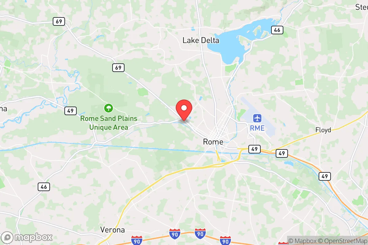
Rome, New York, sits in a position that demands serious attention from anyone thinking about long-term strategic relocation. Its location in the Mohawk Valley, roughly 45 miles east of Syracuse and 15 miles northwest of Utica, places it at a critical junction of infrastructure and natural barriers, but also within worrying proximity to several high-value targets. For a conservative-minded prepper or survivalist, Rome offers a mixed bag: genuine geographic resilience through its canal and river systems, but a vulnerability profile that requires clear-eyed assessment before committing to the area.
Geographic position and natural advantages for long-term security
Rome’s most significant strategic asset is its position within the Mohawk Valley, a natural corridor that has historically funneled transportation and commerce. The city sits at the western end of the Erie Canal, which connects the Hudson River to the Great Lakes, and is flanked by the Adirondack Mountains to the north and the Catskills to the south. This valley provides a defensible chokepoint: any major movement between the eastern seaboard and the interior must pass through this narrow band of lowlands. The surrounding terrain is a mix of rolling hills, farmland, and dense forest, offering multiple avenues for retreat or resupply if the grid goes down. The area’s water resources are substantial—the Mohawk River runs through the city, and the nearby Oneida Lake (the largest lake entirely within New York State) provides a reliable freshwater source. For a relocator focused on self-sufficiency, the region’s agricultural history is still visible: there are working farms within a 20-minute drive, and the soil in the valley is fertile enough to support small-scale food production. The climate is a hardiness zone 5b, with cold winters and moderate summers, meaning a well-insulated home with a wood stove or backup heat source is non-negotiable. The Adirondack Park, just north of Rome, offers over six million acres of public land for hunting, foraging, and emergency shelter, though access is regulated and requires familiarity with state land-use rules.
Risks, exposures, and proximity to fallout-relevant landmarks
Here’s where the analysis gets uncomfortable. Rome’s proximity to several high-consequence targets is the single biggest red flag for a prepper. The city is roughly 30 miles from the Griffiss Business and Technology Park, the former Griffiss Air Force Base, which now hosts the Air Force Research Laboratory and the Eastern Air Defense Sector (EADS). That’s a military command-and-control node that would be a priority target in any major conflict. Additionally, Rome is about 45 miles from the Indian Point Energy Center (though that plant is decommissioned, the spent fuel remains on-site), and roughly 60 miles from the FitzPatrick and Nine Mile Point nuclear plants near Oswego on Lake Ontario. A strike on any of those facilities would put Rome in a dangerous fallout plume depending on wind direction. The city itself is not a major population center—around 32,000 residents—but it sits along the New York State Thruway (I-90) and the CSX rail line, both of which would be choke points for evacuation or supply movement during a crisis. The risk of civil unrest is moderate: Rome has a higher-than-average poverty rate (around 18%) and a shrinking tax base, which could lead to social friction if resources become scarce. The city’s police force is small, and the Oneida County Sheriff’s Office would be stretched thin in a regional emergency. For a relocator, the takeaway is that Rome is not a remote bunker location—it’s a valley town with a military installation next door and major infrastructure running through it. That means you need a plan for evacuation north into the Adirondacks or south into the Catskills if things go hot.
Practical resilience for a relocator: food, water, energy, and defensibility
On the practical side, Rome has some genuine strengths for someone willing to put in the work. The water situation is solid: the Mohawk River is a year-round source, and the city’s municipal water comes from the Hinckley Reservoir, which is fed by the West Canada Creek watershed. A well on private property is the gold standard here, and many rural properties outside city limits have them. For food, the region has a strong network of farmers’ markets, but the real play is in establishing relationships with local growers before a crisis hits. The Oneida County Farm Bureau lists over 200 farms in the county, many of which sell direct to consumers. For energy, the grid is aging and prone to outages during winter storms—ice storms are a recurring threat. Solar panels are viable, but the region’s cloudy winters mean you’ll need battery storage and a backup generator (propane or diesel). Wood heat is the most reliable option, and firewood is abundant if you have the land and the labor. Defensibility is a mixed bag: the valley floor offers limited natural cover, but the hills to the north and south provide good vantage points for a rural homestead. The city itself is not defensible in a collapse scenario—it’s a grid of streets with multiple entry points. The better play is to secure a property on the outskirts, ideally with a clear line of sight to the main roads and a secondary escape route into the forest. The local gun culture is present but not extreme; Oneida County is a mix of rural conservatives and suburban liberals, so you won’t stand out for owning firearms, but you also won’t find the same level of preparedness community as in, say, rural Idaho or Montana. The nearest major medical facility is Rome Memorial Hospital, which is a small community hospital—not a trauma center. For serious injuries, you’re looking at a 45-minute drive to Upstate University Hospital in Syracuse. That’s a vulnerability if the roads are blocked or the system is overwhelmed.
The overall strategic picture for Rome, NY, is one of cautious opportunity. The area offers genuine geographic resilience through its water resources, agricultural potential, and access to vast public lands. But the proximity to military and nuclear targets, combined with the valley’s role as a transportation corridor, means it’s not a place to hunker down and wait out a major conflict. For a single individual or a family with a prepper mindset, Rome works best as a staging ground—a place to build skills, stock supplies, and establish a network, with a clear plan to relocate north into the Adirondacks if the situation deteriorates. The cost of living is low (median home price around $130,000), and the property taxes are high (roughly 2.5% of assessed value), but the land itself is affordable. If you’re looking for a location that balances access to resources with a realistic threat assessment, Rome deserves a spot on your short list—but only if you’re willing to stay mobile and keep your bug-out bag packed.
* Values derived from national, state, county, city and local statistics and may differ in a specific area. Last updated: 2026-05-01T08:45:07.000Z
Narrative content on this page is AI-generated and may contain mistakes. Verify any details that matter before acting on them.
ReloMaps may earn a commission from affiliate links at no extra cost to you.