Photo: Wikipedia
Strategic Assessment of Russellville, AR
Workable tactical position. Some exposure to population density or targets, but generally defensible in a crisis.
What does the Strategic Assessment tell us?
Our Strategic Assessment grades tactical survivability of an area. Major population centers, military targets, fallout zones, natural disasters, and border exposure all drive risk — lower exposure means a more defensible position in a crisis.
This is heavily inspired by Joel Skousen's Strategic Relocation book. Highly recommended you checkout the book ($)What does this tell us?
Our Strategic Assessment grades tactical survivability of an area. Major population centers, military targets, fallout zones, natural disasters, and border exposure all drive risk — lower exposure means a more defensible position in a crisis.
This is heavily inspired by Joel Skousen's Strategic Relocation book. Highly recommended you checkout the book ($)Strategic Pillars

Key Distances
Regional Safe Places
Below is our recommended "safe zones" in Arkansas and the surrounding area based on our strategic heuristics. For most people, it's unrealistic to live in a “safe zone” full-time due to work, family or other personal reasons. They tend to be more rural. However, many of these areas are perfect for second homes and retreat properties that double as a vacation home or even a short-term rental.


Important Note: For informational purposes only. This does not mean nothing bad ever happens in the green zones. Please use common sense. This is based on public data and modeled with AI. We tried to take a conservative approach but mistakes happen. We update this regularly as new information becomes available.
Solar Generator Recommendations
Backup power matters more here than in safer locations. We've picked three solar generators across budgets and capacity tiers — start with the budget unit if you only need a few essentials, or step up if you want to run a fridge and HVAC for days at a time.

Jackery Portable Power Station Explorer 300
Budget OptionPower on the Go: Weighing only 11 lbs, it's convenient to set up and store with book-sized foldable solar panels

BLUETTI Portable Power Station AC180
Designed for both indoor and outdoor scenarios, AC180 is highly capable as it has a robost capacity and continuous output power.

EF ECOFLOW DELTA Pro Ultra Power Station
Upgraded PickEcoFlow DELTA Pro Ultra is a whole-home energy system designed to grow with your family. Integrated with the Smart Home Panel 2, it scales to meet your evolving energy needs — keeping your home powered, intelligent, and secure through every stage of life.
We earn a commission, at no additional cost to you.
Strategic Assessment Analysis
Russellville, Arkansas, sits in a strategic sweet spot that resilience-minded relocators should take seriously: far enough from major metropolitan chaos to offer genuine buffer, yet close enough to the Arkansas River Valley’s resources to sustain a household through disruption. The city’s position along Interstate 40 gives it a logistical spine, but its location in the foothills of the Ozarks and Ouachitas provides natural terrain advantages that flatland communities simply don’t have. For a conservative-leaning individual or family looking to plant roots in a place that can weather civic unrest, supply chain failures, or natural disasters, Russellville offers a blend of geographic insulation, resource access, and community scale that is increasingly rare in the Lower 48.
Geographic position and natural advantages for long-term security
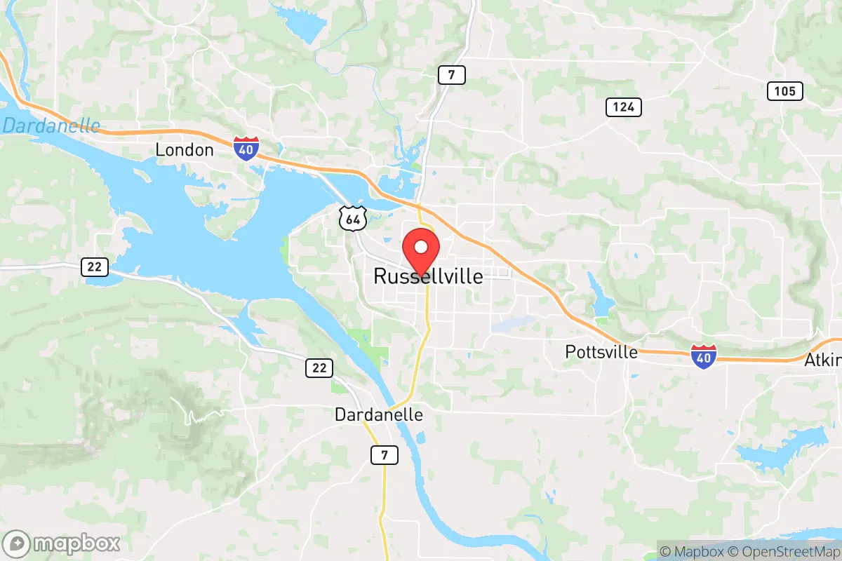
Russellville’s location in Pope County places it at the southern edge of the Boston Mountains, where the Arkansas River Valley meets the Ozark Plateau. This transition zone gives the area a mix of forested ridges, limestone bluffs, and fertile bottomlands that support both hunting and small-scale agriculture. The city itself sits at roughly 350 feet elevation, but within a 15-minute drive you can gain 500–800 feet of vertical relief into the Ozark National Forest, which offers natural cover, water sources, and defensible positions. The Arkansas River runs just south of town, providing a reliable surface water source that isn’t dependent on municipal infrastructure. Unlike the alluvial plains of eastern Arkansas, the terrain here is naturally resistant to large-scale flooding in most residential areas, though low-lying spots near the river do carry some risk. The region’s karst geology means numerous springs and seeps exist in the surrounding hills, which can be developed into off-grid water supplies with basic knowledge. For a prepper household, the ability to move from town into the national forest within 20 minutes is a major tactical advantage—whether for bug-out scenarios, resupply caching, or simply maintaining a low profile during periods of unrest.
Risks, exposures, and proximity to fallout-relevant landmarks
No location is without vulnerabilities, and Russellville has a few that demand honest assessment. The most obvious is Interstate 40, which runs directly through the city. In a national emergency—whether a pandemic, fuel shortage, or civil unrest—I-40 becomes a chokepoint and a vector for displaced populations moving west from Memphis or east from Oklahoma City. Russellville’s position as a regional trade hub means it could see transient traffic surges that strain local resources. Additionally, the Arkansas Nuclear One plant is located just six miles west of downtown, on Lake Dardanelle. While the plant has a solid safety record, any nuclear facility within 20 miles is a liability in a worst-case scenario—whether from accident, sabotage, or wartime targeting. The prevailing winds in the Arkansas River Valley run west to east, meaning a release would push fallout toward Russellville and further into the Ozarks. For the truly risk-averse, this is the single biggest red flag on the map. On the plus side, the city is over 100 miles from any major metropolitan area (Little Rock is 75 miles southeast, Fort Smith 60 miles west, and Tulsa 130 miles northwest), which dramatically reduces the risk of being caught in urban unrest, food riots, or mass evacuation traffic jams. There are no major military bases, chemical plants, or dam complexes within the immediate blast radius, which keeps the primary threat profile narrow and manageable for a prepared household.
Practical resilience for a relocator: food, water, energy, and defensibility
For a family or individual serious about self-sufficiency, Russellville’s practical assets are strong. The surrounding Pope and Yell counties are agriculturally productive, with row crops (soybeans, corn, wheat) in the river bottoms and pastureland for cattle throughout the hills. Local farmers’ markets operate seasonally, and the region has a robust network of small-scale producers who sell meat, eggs, and produce directly—relationships that can be cultivated before any crisis hits. Water access is above average: the Arkansas River and Lake Dardanelle provide surface water, while the Ozark aquifer system offers groundwater that can be tapped with a well at depths of 100–300 feet in most areas. The city’s municipal water comes from the river, but a prepper household should plan for a backup well or rainwater catchment system, as municipal treatment could fail during a prolonged grid-down event. Energy resilience is mixed. The grid here is served by Entergy Arkansas and several rural electric cooperatives, and power outages from ice storms are a recurring winter reality—meaning locals are already accustomed to generator use and wood heat. Solar potential is decent, with roughly 200 sunny days per year, though the tree canopy in the hills can limit panel placement. Natural gas is available in town but not in outlying areas, so propane storage is a common workaround. Defensibility is where Russellville truly shines. The terrain offers natural chokepoints on the roads leading into the valley, and the surrounding national forest provides both cover and a buffer against large-scale movement. The local population is predominantly rural and conservative, with a strong hunting culture and a high rate of firearm ownership—factors that tend to discourage opportunistic crime during breakdowns. The county sheriff’s office is well-regarded, and the city police department maintains a visible presence, but in a true SHTF scenario, the community’s self-policing ethos is a more reliable asset than any formal institution.
The overall strategic picture for Russellville is one of moderate risk with high reward for the prepared. The nuclear plant is a legitimate concern that cannot be dismissed, but it is a single, known variable that can be mitigated with a bug-out plan into the Ozark National Forest to the north. The I-40 corridor is a double-edged sword—useful for supply runs in normal times, dangerous during mass migrations. For a conservative relocator who values community cohesion, natural resource access, and terrain that favors the defender, Russellville offers a solid foundation. It is not a remote bunker location, nor is it a fortified compound; it is a working-class Arkansas town with good bones, decent infrastructure, and a population that largely shares the values of self-reliance and mutual aid. If you are looking for a place that can sustain a family through the next decade of uncertainty without requiring you to live off-grid in a yurt, Russellville deserves a hard look. Just keep a bug-out bag pointed north and a good map of the forest service roads.
* Values derived from national, state, county, city and local statistics and may differ in a specific area. Last updated: 2026-04-21T07:16:39.000Z
Narrative content on this page is AI-generated and may contain mistakes. Verify any details that matter before acting on them.
ReloMaps may earn a commission from affiliate links at no extra cost to you.