Photo: Wikipedia
Strategic Assessment of Sandpoint, ID
Workable tactical position. Some exposure to population density or targets, but generally defensible in a crisis.
What does the Strategic Assessment tell us?
Our Strategic Assessment grades tactical survivability of an area. Major population centers, military targets, fallout zones, natural disasters, and border exposure all drive risk — lower exposure means a more defensible position in a crisis.
This is heavily inspired by Joel Skousen's Strategic Relocation book. Highly recommended you checkout the book ($)What does this tell us?
Our Strategic Assessment grades tactical survivability of an area. Major population centers, military targets, fallout zones, natural disasters, and border exposure all drive risk — lower exposure means a more defensible position in a crisis.
This is heavily inspired by Joel Skousen's Strategic Relocation book. Highly recommended you checkout the book ($)Strategic Pillars

Key Distances
Regional Safe Places
Below is our recommended "safe zones" in Idaho and the surrounding area based on our strategic heuristics. For most people, it's unrealistic to live in a “safe zone” full-time due to work, family or other personal reasons. They tend to be more rural. However, many of these areas are perfect for second homes and retreat properties that double as a vacation home or even a short-term rental.


Important Note: For informational purposes only. This does not mean nothing bad ever happens in the green zones. Please use common sense. This is based on public data and modeled with AI. We tried to take a conservative approach but mistakes happen. We update this regularly as new information becomes available.
Solar Generator Recommendations
Backup power matters more here than in safer locations. We've picked three solar generators across budgets and capacity tiers — start with the budget unit if you only need a few essentials, or step up if you want to run a fridge and HVAC for days at a time.

Jackery Portable Power Station Explorer 300
Budget OptionPower on the Go: Weighing only 11 lbs, it's convenient to set up and store with book-sized foldable solar panels

BLUETTI Portable Power Station AC180
Designed for both indoor and outdoor scenarios, AC180 is highly capable as it has a robost capacity and continuous output power.

EF ECOFLOW DELTA Pro Ultra Power Station
Upgraded PickEcoFlow DELTA Pro Ultra is a whole-home energy system designed to grow with your family. Integrated with the Smart Home Panel 2, it scales to meet your evolving energy needs — keeping your home powered, intelligent, and secure through every stage of life.
We earn a commission, at no additional cost to you.
Strategic Assessment Analysis
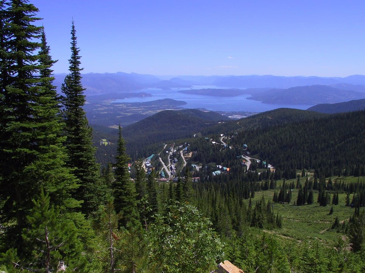
Sandpoint, Idaho, sits in a geographic sweet spot that combines genuine strategic depth with the kind of everyday livability that makes long-term preparation sustainable. Nestled against the Selkirk and Cabinet Mountains on the northern shore of Lake Pend Oreille, this town of roughly 10,000 people offers a rare combination: it is remote enough to avoid the immediate blast zones and urban chaos of the West Coast, yet connected enough to maintain supply lines and communication. For a relocator thinking in terms of decades, not just the next election cycle, Sandpoint represents a position that is defensible, resource-rich, and far enough from the major fault lines—both geological and societal—to buy you time.
Geographic position and natural advantages for long-term security
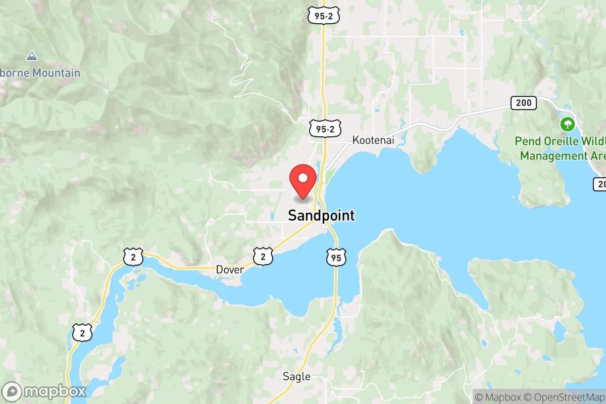
Sandpoint’s primary strategic asset is its location relative to the major population centers that would become liabilities in a crisis. It sits roughly 300 miles from Seattle, 350 miles from Portland, and about 90 miles from Spokane—close enough to access medical and supply hubs in normal times, but far enough that a cascading urban collapse would take days or weeks to reach you. The town is flanked by the Selkirk Mountains to the east and the Cabinet Mountains to the west, with the Purcell Trench running north-south. This topography creates natural chokepoints: the only major road access is via U.S. Highway 95, which runs north to the Canadian border and south to Coeur d'Alene. In a grid-down scenario, a small group could effectively monitor or block that single corridor. The lake itself—Lake Pend Oreille, the deepest lake in the Pacific Northwest at 1,150 feet—provides a massive freshwater reservoir that is fed by the Clark Fork River and is unlikely to dry up even in extended drought. The surrounding national forests (Kaniksu, Coeur d'Alene, and Kootenai) offer timber, game, and forage, though you should not assume you can live off the land without serious prior training. The area’s elevation (around 2,100 feet) and latitude mean winters are cold and snowy, which acts as a natural filter: only those willing to deal with real winter will stay. That same winter also reduces the risk of wildfire compared to drier parts of the inland Northwest, though fire risk is not zero.
Risks, exposures, and proximity to fallout-relevant landmarks
No location is a fortress, and Sandpoint has specific vulnerabilities that a serious prepper must account for. The most obvious is the Fairchild Air Force Base near Spokane, which houses the 92nd Air Refueling Wing and is a likely target in any major conflict involving the United States. While Sandpoint is 90 miles from Fairchild, prevailing winds in this region generally blow from the west and southwest, meaning fallout from a strike on Spokane or Fairchild could drift toward the Idaho Panhandle depending on the season. You need to have a fallout shelter plan, not just a bug-out bag. The second risk is the rail corridor that runs through Sandpoint—the Burlington Northern Santa Fe mainline that carries freight and, critically, hazardous materials through the center of town. A derailment or intentional sabotage could release chlorine, ammonia, or other industrial chemicals, forcing an evacuation or shelter-in-place scenario. Third, the area is in Seismic Zone 2B, which is moderate but not negligible; the nearby Newport Fault and the larger seismic activity in the Pacific Northwest mean that a major earthquake could disrupt roads, power, and water for weeks. Finally, Sandpoint’s popularity as a tourist and second-home destination means that in a sudden crisis—pandemic, economic collapse, or regional blackout—the population could spike as wealthy outsiders flee to their lake houses, straining local food, fuel, and medical resources. The town’s permanent population of about 10,000 can swell to over 30,000 in summer, and that transient population is not prepared for self-sufficiency.
Practical resilience for a relocator: food, water, energy, and defensibility
For the individual or family looking to establish a resilient household, Sandpoint offers a mix of advantages and gaps that require deliberate preparation. Water is abundant: Lake Pend Oreille is drinkable with basic filtration, and the aquifer beneath the valley is deep and clean. Many properties have wells, and the local water table is high enough that hand-pumping is feasible. However, the municipal water system relies on electric pumps, so a grid failure means no pressure. You need a backup well pump (hand or solar) and at least two weeks of stored water per person. Food production is viable but not automatic: the growing season is short (roughly 90–120 frost-free days), and the soil is rocky and acidic in many areas. Raised beds, greenhouses, and cold frames are essential for serious gardening. The local farmers' market and co-op (Winter Ridge Natural Foods) are good for normal times, but in a crisis, you cannot rely on them. The surrounding forests support deer, elk, and grouse, but hunting pressure is high, and you will compete with other preppers. Energy is a mixed picture: Bonner County has decent solar insolation for the Pacific Northwest (about 4.5 peak sun hours per day in summer, dropping to 1.5 in December), so a solar array with battery storage is viable but must be oversized for winter. Wood heat is the default backup for most locals; the national forests offer firewood permits, but you need a chainsaw, a splitter, and dry storage. Propane is widely available but subject to supply chain disruptions. Defensibility is good but not perfect: the terrain provides natural cover and chokepoints, but the town itself is not a fortress. A rural property on a dead-end road with a creek or lake on one side is ideal. The local sheriff’s office is professional but small—about 25 deputies for the entire county—so in a prolonged crisis, you are largely on your own. The community culture leans heavily toward self-reliance, gun ownership is common, and there is a strong network of retired military and law enforcement in the area. That is a double-edged sword: you have capable neighbors, but they are also prepared and may not have surplus to share.
The overall strategic picture for Sandpoint is that it is one of the better options in the lower 48 for a relocator who wants to be out of the blast radius of major cities while still having access to modern infrastructure in normal times. It is not a bug-out location for a weekend; it is a place to build a life that is already oriented toward resilience. The downsides—winter severity, tourist influx, rail hazards, and moderate earthquake risk—are manageable with planning and investment. The upsides—abundant water, defensible terrain, low population density, and a culture that does not look down on preparedness—are hard to find in combination elsewhere. If you are serious about being ready for the next decade of instability, Sandpoint deserves a hard look. Just do not move here expecting to coast; the mountains and the lake will demand your respect, and the neighbors will expect you to pull your weight.
* Values derived from national, state, county, city and local statistics and may differ in a specific area. Last updated: 2026-04-21T09:14:03.000Z
Narrative content on this page is AI-generated and may contain mistakes. Verify any details that matter before acting on them.
ReloMaps may earn a commission from affiliate links at no extra cost to you.