
Photo: Wikipedia
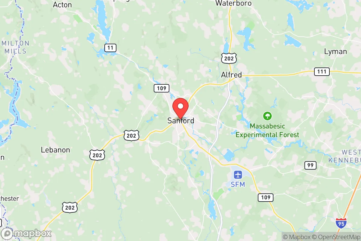
Strategic Assessment of Sanford, ME
Multiple tactical vulnerabilities. Population density, target proximity, or disaster risk are likely compounding. A retreat property and exit planning is required.
What does the Strategic Assessment tell us?
Our Strategic Assessment grades tactical survivability of an area. Major population centers, military targets, fallout zones, natural disasters, and border exposure all drive risk — lower exposure means a more defensible position in a crisis.
This is heavily inspired by Joel Skousen's Strategic Relocation book. Highly recommended you checkout the book ($)What does this tell us?
Our Strategic Assessment grades tactical survivability of an area. Major population centers, military targets, fallout zones, natural disasters, and border exposure all drive risk — lower exposure means a more defensible position in a crisis.
This is heavily inspired by Joel Skousen's Strategic Relocation book. Highly recommended you checkout the book ($)Strategic Pillars

Key Distances
Regional Safe Places
Below is our recommended "safe zones" in Maine and the surrounding area based on our strategic heuristics. For most people, it's unrealistic to live in a “safe zone” full-time due to work, family or other personal reasons. They tend to be more rural. However, many of these areas are perfect for second homes and retreat properties that double as a vacation home or even a short-term rental.


Important Note: For informational purposes only. This does not mean nothing bad ever happens in the green zones. Please use common sense. This is based on public data and modeled with AI. We tried to take a conservative approach but mistakes happen. We update this regularly as new information becomes available.
Solar Generator Recommendations
Backup power matters more here than in safer locations. We've picked three solar generators across budgets and capacity tiers — start with the budget unit if you only need a few essentials, or step up if you want to run a fridge and HVAC for days at a time.

Jackery Portable Power Station Explorer 300
Budget OptionPower on the Go: Weighing only 11 lbs, it's convenient to set up and store with book-sized foldable solar panels

BLUETTI Portable Power Station AC180
Designed for both indoor and outdoor scenarios, AC180 is highly capable as it has a robost capacity and continuous output power.

EF ECOFLOW DELTA Pro Ultra Power Station
Upgraded PickEcoFlow DELTA Pro Ultra is a whole-home energy system designed to grow with your family. Integrated with the Smart Home Panel 2, it scales to meet your evolving energy needs — keeping your home powered, intelligent, and secure through every stage of life.
We earn a commission, at no additional cost to you.
Strategic Assessment Analysis
Sanford, Maine, sits in a strategic sweet spot that few relocators fully appreciate: close enough to the economic engine of the Boston-to-Portland corridor to access jobs and supplies, yet far enough from the dense population centers that would become chokepoints during a crisis. Its location along the Mousam River and its position as the largest inland city in York County give it a resilience profile that balances accessibility with buffer. For a conservative-leaning individual or family thinking about long-term preparedness, Sanford offers a rare combination of rural character, regional infrastructure, and geographic insulation from the worst fallout scenarios.
Geographic position and natural advantages for long-term stability
Sanford’s location roughly 30 miles from the Atlantic coast and 35 miles from Portland places it outside the immediate blast radius of any coastal or urban target, yet within a day’s drive of multiple supply chains. The Mousam River provides a reliable freshwater source, and the surrounding York County landscape is a mix of forested hills, wetlands, and farmland—terrain that supports both hunting and small-scale agriculture. The area’s elevation, averaging around 300 feet, keeps it above most flood zones while still benefiting from the moderating influence of the Gulf of Maine on winter temperatures. Sanford’s position along the Route 4 corridor gives it direct road access to the New Hampshire border and the broader I-95 network, which is critical for both evacuation and resupply. The town’s historic role as a mill hub means its downtown is compact and walkable, reducing dependence on vehicles for daily errands—a subtle but real advantage if fuel becomes scarce.
Risks, exposures, and proximity to fallout-relevant landmarks
No location is without vulnerabilities, and Sanford has several that a serious prepper must weigh. The most obvious is its proximity to the Boston metropolitan area, roughly 80 miles to the southwest. While that distance provides a buffer against direct blast effects from a nuclear or conventional attack on Boston, it puts Sanford within the fallout plume zone for any high-yield detonation targeting the city. Prevailing winds in the region blow from the west and southwest, meaning fallout from a Boston strike would likely drift toward the coast, not inland toward Sanford, but that’s a statistical comfort, not a guarantee. The Portsmouth Naval Shipyard, located about 25 miles southeast on the Maine-New Hampshire border, is a Tier 1 military asset and a plausible target for sabotage or missile attack. Sanford’s own municipal airport, while small, could become a secondary target if the military uses it for staging. On the natural disaster side, the area faces moderate risks from nor’easters and ice storms, which can knock out power for days or weeks. Sanford sits in a designated floodplain along the Mousam River, and while the town has improved its drainage infrastructure, heavy rain events tied to climate shifts could still cause localized flooding in low-lying neighborhoods. The risk of wildfire is low compared to the West, but the surrounding forests are dense enough that a dry summer could produce a significant brush fire near residential edges.
Practical resilience for a relocator: food, water, energy, and defensibility
For a family or individual serious about self-reliance, Sanford offers a workable baseline but requires deliberate upgrades. The Mousam River is the obvious water source, but it’s also a public water supply for the town, meaning any contamination event—whether from upstream industrial runoff or deliberate sabotage—would affect everyone drawing from the municipal system. Installing a private well is feasible in most parts of Sanford, with typical depths of 100 to 200 feet yielding reliable groundwater, but the cost runs $5,000 to $15,000 depending on location and rock conditions. The town’s soil is a mix of sandy loam and clay, which drains well enough for gardening but requires amendment for serious crop production. The growing season is short—roughly 140 days—so cold frames or a greenhouse are necessary for year-round food security. Local farmers’ markets operate from May through October, and several nearby farms offer raw milk, eggs, and meat through private arrangements, which aligns with a conservative preference for direct producer-to-consumer relationships. Energy resilience is a mixed bag: Central Maine Power’s grid is aging and prone to outages during storms, but solar potential is decent, with about 4.5 peak sun hours per day. Installing a grid-tied solar array with battery backup can cost $15,000 to $25,000 after federal tax credits, and several local installers service the area. Wood heat is a practical alternative, with firewood available from local loggers at $200 to $300 per cord. Defensibility is where Sanford shows its limits: the town’s layout is spread out, with many homes on cul-de-sacs or dead-end roads that create natural chokepoints for security, but the overall population density of about 600 people per square mile means neighbors are close enough to notice trouble but far enough to avoid constant friction. The York County Sheriff’s Office has a visible presence, but response times in the outer parts of town can exceed 20 minutes, so a relocator should plan for self-defense capability and a neighborhood watch network.
The overall strategic picture for Sanford is one of cautious optimism for a prepared relocator. It’s not a hardened bunker location like the remote Rockies, nor is it a coastal vulnerability like Portland or Boston. It’s a middle-ground option that rewards investment in infrastructure and community ties. The town’s conservative-leaning population—York County voted for Trump in 2020 by a margin of about 52% to 46%—means a relocator will find neighbors who share a skepticism of federal overreach and a preference for local control. The local economy is anchored by manufacturing, healthcare, and logistics, with major employers like Pratt & Whitney and the Sanford School Department providing stable jobs that don’t depend on government contracts. For a family willing to drill a well, install solar, and build a root cellar, Sanford offers a defensible position with access to the resources of the Northeast without being swallowed by its vulnerabilities. The key is to act before the next crisis drives up real estate prices and strains the town’s carrying capacity. If you’re looking for a place that balances retreat with practicality, Sanford deserves a serious look.
* Values derived from national, state, county, city and local statistics and may differ in a specific area. Last updated: 2026-04-19T06:21:20.000Z
Narrative content on this page is AI-generated and may contain mistakes. Verify any details that matter before acting on them.
ReloMaps may earn a commission from affiliate links at no extra cost to you.