
Photo: Wikipedia
Strategic Assessment of Schenectady, NY
Multiple tactical vulnerabilities. Population density, target proximity, or disaster risk are likely compounding. A retreat property and exit planning is required.
What does the Strategic Assessment tell us?
Our Strategic Assessment grades tactical survivability of an area. Major population centers, military targets, fallout zones, natural disasters, and border exposure all drive risk — lower exposure means a more defensible position in a crisis.
This is heavily inspired by Joel Skousen's Strategic Relocation book. Highly recommended you checkout the book ($)What does this tell us?
Our Strategic Assessment grades tactical survivability of an area. Major population centers, military targets, fallout zones, natural disasters, and border exposure all drive risk — lower exposure means a more defensible position in a crisis.
This is heavily inspired by Joel Skousen's Strategic Relocation book. Highly recommended you checkout the book ($)Strategic Pillars

Key Distances
Regional Safe Places
Below is our recommended "safe zones" in New York and the surrounding area based on our strategic heuristics. For most people, it's unrealistic to live in a “safe zone” full-time due to work, family or other personal reasons. They tend to be more rural. However, many of these areas are perfect for second homes and retreat properties that double as a vacation home or even a short-term rental.


Important Note: For informational purposes only. This does not mean nothing bad ever happens in the green zones. Please use common sense. This is based on public data and modeled with AI. We tried to take a conservative approach but mistakes happen. We update this regularly as new information becomes available.
Solar Generator Recommendations
Backup power matters more here than in safer locations. We've picked three solar generators across budgets and capacity tiers — start with the budget unit if you only need a few essentials, or step up if you want to run a fridge and HVAC for days at a time.

Jackery Portable Power Station Explorer 300
Budget OptionPower on the Go: Weighing only 11 lbs, it's convenient to set up and store with book-sized foldable solar panels

BLUETTI Portable Power Station AC180
Designed for both indoor and outdoor scenarios, AC180 is highly capable as it has a robost capacity and continuous output power.

EF ECOFLOW DELTA Pro Ultra Power Station
Upgraded PickEcoFlow DELTA Pro Ultra is a whole-home energy system designed to grow with your family. Integrated with the Smart Home Panel 2, it scales to meet your evolving energy needs — keeping your home powered, intelligent, and secure through every stage of life.
We earn a commission, at no additional cost to you.
Strategic Assessment Analysis
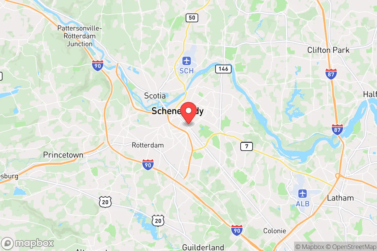
Schenectady, New York, presents a mixed strategic picture for the conservative prepper or survivalist. Its primary resilience advantage is its location within the Mohawk Valley, a natural corridor that historically served as a defensive chokepoint and a route away from the densest coastal populations. However, its proximity to the Albany-Schenectady-Troy metropolitan area—a major state government and logistics hub—introduces significant vulnerabilities, including potential civil unrest and target risk. For a relocator seeking a balance between rural retreat and access to infrastructure, Schenectady offers a plausible, if imperfect, base of operations, provided you understand its specific exposures and plan accordingly.
Geographic position and natural defensive advantages of the Mohawk Valley
Schenectady sits at the confluence of the Mohawk River and the Erie Canal, roughly 15 miles northwest of Albany. This position is the western gateway to the Hudson Valley, and historically, the Mohawk Valley has been a strategic military and trade route. For the prepper, this geography offers several key advantages. The valley is flanked by the Adirondack Mountains to the north and the Catskills to the south, providing natural barriers that can slow movement and offer escape routes into less populated, forested terrain. The Mohawk River itself is a significant water source, though its industrial history means you should not rely on it untreated. The region's topography—rolling hills, river valleys, and dense woodlands—creates numerous defensible positions for a rural homestead or retreat, especially if you move 20-30 minutes north or west of the city center. The area also benefits from a relatively low population density compared to the I-95 corridor, with Schenectady County itself holding about 155,000 people. This reduces the immediate pressure of a mass evacuation from the coast, though the city itself remains a potential chokepoint.
Risks, exposures, and proximity to fallout-relevant landmarks
The most significant downside for a survivalist is Schenectady's proximity to multiple high-value targets. The city is less than 20 miles from the New York State Capitol in Albany, a likely focal point for civil unrest, political demonstrations, and potential martial law enforcement. The Albany International Airport, a major cargo and military airlift hub, is a primary target in any conflict scenario. Furthermore, the entire Capital District is crisscrossed by major rail lines (CSX, Norfolk Southern) and interstate highways (I-90, I-87, I-88) that would be choked with refugees and military convoys during a crisis. The nearby Knolls Atomic Power Laboratory (a naval nuclear propulsion research facility) and the GlobalFoundries semiconductor plant in Malta (a critical national security asset) are specific, high-consequence targets. A conventional or EMP attack on either would create a massive fallout zone and disrupt regional power and communications. The city's own industrial past has left legacy contamination in the Mohawk River and soil, meaning long-term subsistence farming or water collection requires careful testing. For the prepper, the key takeaway is that Schenectady itself is not a safe haven—it is a staging area. Your bug-out location must be at least 30 miles northwest or southwest of the city, ideally in the foothills of the Adirondacks or Catskills, to be outside the immediate blast and fallout radius of these targets.
Practical resilience for a relocator: food, water, energy, and defensibility
For a single individual or family looking to establish a resilient lifestyle, Schenectady offers a mixed bag. On the positive side, the region has a strong agricultural heritage. The Mohawk Valley is home to numerous small farms, orchards, and farmers' markets, making local food sourcing relatively easy in normal times. The growing season is short (roughly May to September), but the soil is fertile, and there is ample land for gardening or small-scale livestock within a 15-minute drive of the city. Water is abundant from the Mohawk River and numerous smaller creeks and wells, but you must plan for filtration and purification—municipal water is treated but vulnerable to contamination or shutdown. Energy resilience is a challenge. The region is served by National Grid, and power outages from winter storms (ice, snow, wind) are common. Solar is viable but requires battery storage due to frequent cloud cover. Natural gas is available in the city, but rural properties often rely on propane or heating oil. Defensibility is moderate. The city's dense, older neighborhoods (like the Stockade Historic District) offer some natural chokepoints and brick construction, but they are also high-traffic areas. A better strategy is to secure a property on a dead-end road or a small acreage with a clear line of sight to the only approach. The local gun culture is present but not as dominant as in the South or Midwest; New York State's strict gun laws (permits, magazine limits, SAFE Act) are a major drawback for the armed prepper. You will need to navigate a complex legal landscape to own and carry firearms, and magazine capacity is limited to 10 rounds. This is a significant strategic disadvantage compared to states with fewer restrictions.
Overall, Schenectady is a strategic compromise. It offers a defensible geographic position, access to water and farmland, and a lower population density than the coastal megacities. However, it is not a remote sanctuary. Its proximity to Albany, critical infrastructure, and nuclear research facilities makes it a high-risk area for any major conflict or disaster. For the conservative relocator, the smart play is to use Schenectady as a base for employment and supply acquisition while establishing a primary retreat in the more remote Adirondack foothills or the rural areas of Schoharie or Montgomery counties. If you are willing to navigate New York's regulatory environment and accept the risks of being near a state capital, this area can work—but only with a clear, practiced plan for evacuation and a hardened, self-sufficient property outside the immediate danger zone. It is not a place to hunker down in the city; it is a place to stage and then move when the situation demands.
* Values derived from national, state, county, city and local statistics and may differ in a specific area. Last updated: 2026-05-01T19:42:52.000Z
Narrative content on this page is AI-generated and may contain mistakes. Verify any details that matter before acting on them.
ReloMaps may earn a commission from affiliate links at no extra cost to you.