
Photo: Wikipedia
Strategic Assessment of Selbyville, DE
Multiple tactical vulnerabilities. Population density, target proximity, or disaster risk are likely compounding. A retreat property and exit planning is required.
What does the Strategic Assessment tell us?
Our Strategic Assessment grades tactical survivability of an area. Major population centers, military targets, fallout zones, natural disasters, and border exposure all drive risk — lower exposure means a more defensible position in a crisis.
This is heavily inspired by Joel Skousen's Strategic Relocation book. Highly recommended you checkout the book ($)What does this tell us?
Our Strategic Assessment grades tactical survivability of an area. Major population centers, military targets, fallout zones, natural disasters, and border exposure all drive risk — lower exposure means a more defensible position in a crisis.
This is heavily inspired by Joel Skousen's Strategic Relocation book. Highly recommended you checkout the book ($)Strategic Pillars

Key Distances
Regional Safe Places
Below is our recommended "safe zones" in Delaware and the surrounding area based on our strategic heuristics. For most people, it's unrealistic to live in a “safe zone” full-time due to work, family or other personal reasons. They tend to be more rural. However, many of these areas are perfect for second homes and retreat properties that double as a vacation home or even a short-term rental.


Important Note: For informational purposes only. This does not mean nothing bad ever happens in the green zones. Please use common sense. This is based on public data and modeled with AI. We tried to take a conservative approach but mistakes happen. We update this regularly as new information becomes available.
Solar Generator Recommendations
Backup power matters more here than in safer locations. We've picked three solar generators across budgets and capacity tiers — start with the budget unit if you only need a few essentials, or step up if you want to run a fridge and HVAC for days at a time.

Jackery Portable Power Station Explorer 300
Budget OptionPower on the Go: Weighing only 11 lbs, it's convenient to set up and store with book-sized foldable solar panels

BLUETTI Portable Power Station AC180
Designed for both indoor and outdoor scenarios, AC180 is highly capable as it has a robost capacity and continuous output power.

EF ECOFLOW DELTA Pro Ultra Power Station
Upgraded PickEcoFlow DELTA Pro Ultra is a whole-home energy system designed to grow with your family. Integrated with the Smart Home Panel 2, it scales to meet your evolving energy needs — keeping your home powered, intelligent, and secure through every stage of life.
We earn a commission, at no additional cost to you.
Strategic Assessment Analysis
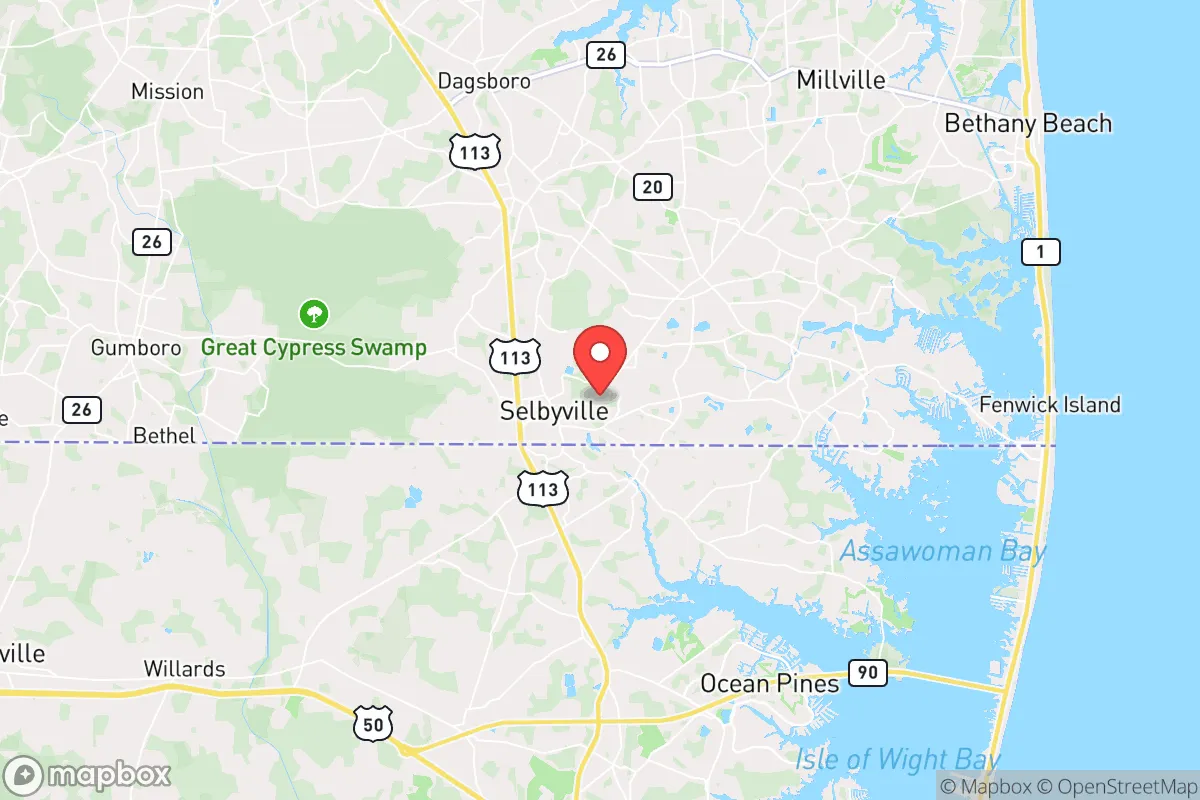
Selbyville, Delaware, sits in a strategic sweet spot that resilience-minded relocators should take seriously: far enough from major metropolitan chaos to offer genuine buffer, yet close enough to the Delmarva Peninsula’s logistical spine to keep supply lines open. This small town in Sussex County benefits from being off the beaten path of I-95’s corridor of vulnerability, while still having access to the agricultural and maritime resources that make long-term self-sufficiency plausible. For someone weighing the risks of civic unrest, grid collapse, or mass casualty events, Selbyville presents a low-profile option with real defensive and logistical advantages — provided you understand its specific exposures.
Geographic position and natural advantages for long-term security
Selbyville’s location on the southern edge of Delaware, just a few miles from the Maryland line, places it in a region that is both ecologically productive and strategically underdeveloped. The town sits within the Delmarva Peninsula, a landmass bounded by the Chesapeake Bay to the west and the Atlantic Ocean to the east, which naturally limits approach vectors for any large-scale unrest or military-style threat. The surrounding landscape is flat, agricultural, and sparsely populated compared to the I-95 corridor — think cornfields, poultry farms, and pine forests rather than strip malls and subdivisions. This low population density (Sussex County has roughly 240 people per square mile, versus over 1,100 in New Castle County to the north) means fewer potential flashpoints and more room to maneuver if things go sideways. The area’s groundwater is plentiful, with the Columbia Aquifer providing reliable freshwater at shallow depths — a critical advantage if municipal systems fail. Selbyville also sits within a day’s walk of the Atlantic coast, offering access to marine protein and saltwater for preservation, though the beach towns themselves (like Ocean City, MD, 20 miles east) are potential evacuation magnets during a crisis. The town’s agricultural base — poultry processing, grain farming, and produce — means local food production is not just theoretical; it’s the actual economy. For a relocator thinking in terms of months or years of disruption, that’s a concrete asset.
Risks, exposures, and proximity to fallout-relevant landmarks
No location is immune, and Selbyville has specific vulnerabilities that a prepper must account for. The most obvious is its proximity to the Indian River Power Plant, a coal-and-gas facility about 15 miles north near Millsboro. While not a nuclear reactor, it’s a critical energy node that could become a target during civil unrest or a cyberattack on the grid — a single point of failure for regional power. Closer to home, the town is roughly 25 miles from the Salem-Hope Creek nuclear generating station in New Jersey, across Delaware Bay. That’s within the 50-mile ingestion exposure zone, meaning a major release could contaminate local water and crops. The prevailing winds in this region are from the west and southwest, which would carry fallout toward the Atlantic rather than directly over Selbyville, but it’s not a zero-risk scenario. On the human threat side, Selbyville is about 30 miles from the Dover Air Force Base, a major military logistics hub that could become a staging area during national emergencies — drawing both federal presence and potential protest activity. The town is also within a two-hour drive of Philadelphia, Baltimore, and Washington, D.C., meaning any mass casualty event or civil unrest in those cities could send refugees streaming down Route 113 and Route 54. Selbyville’s position as a small town on a major evacuation corridor (US 113 runs straight through it) is a double-edged sword: it offers escape routes north or south, but also funnels displaced populations through your backyard. Flooding is another seasonal risk — the area is low-lying, and hurricanes or nor’easters can push tidal surges up the Indian River and Assawoman Bay, cutting off roads and contaminating wells. The 2023 flooding from Hurricane Lee, while minor, was a reminder that this is not high ground.
Practical resilience for a relocator: food, water, energy, and defensibility
For someone serious about self-reliance, Selbyville offers a mix of immediate advantages and required workarounds. Water is the strongest asset: the Columbia Aquifer provides clean groundwater at depths of 50-150 feet, and many rural properties already have private wells. Even if the municipal system fails, a hand pump or solar-powered well can keep you in water indefinitely. The town’s water table is high enough that shallow wells are feasible, but you’ll want to test for agricultural runoff (nitrates from poultry fertilizer are a known issue in Sussex County). Food production is viable year-round: the growing season runs from April to October, and the sandy loam soil is good for root vegetables, corn, and beans. Local poultry farms mean a steady supply of manure for composting, and the nearby Atlantic offers fishing and crabbing (though you’ll need to monitor for contamination after any industrial accident). For long-term storage, the area’s humidity is a challenge — mold and spoilage are real risks without proper drying and sealing. Energy resilience requires planning: the grid here is served by Delmarva Power, which has a mixed reliability record during storms. Solar is viable (the region gets about 200 sunny days per year), but net metering policies in Delaware are favorable — you can offset grid dependence without going off-grid entirely. Propane is widely available for backup generation, and wood heating is practical given the surrounding forests. Defensibility is moderate: Selbyville itself is a compact town of about 2,500 people, with a grid street layout that offers limited natural chokepoints. The real defensive value lies in the rural outskirts — properties with long driveways, tree lines, and distance from main roads are available within a 10-minute drive of town. The local law enforcement presence is small (Selbyville Police Department has about a dozen officers), so in a prolonged crisis, you’d be relying on community networks and your own capabilities. The town’s demographic is older and conservative-leaning, which can be a double-edged sword: neighbors are likely to be armed and self-reliant, but also less mobile and potentially more dependent on outside help during a disaster.
The overall strategic picture for Selbyville is one of guarded optimism for the prepared relocator. It’s not a hardened bunker location — it’s a working-class farm town with real exposure to coastal weather, industrial accidents, and refugee flows from the Northeast corridor. But its agricultural base, abundant groundwater, and low profile make it a far better bet than suburban subdivisions or dense urban centers. The key is to treat Selbyville as a base of operations rather than a fortress: stockpile for 90 days minimum, invest in well water and solar, and build relationships with local farmers and hunters before a crisis hits. If you’re looking for a place that balances accessibility with buffer, and where the local economy already revolves around the kind of skills you’d need in a collapse — growing food, fixing machinery, and keeping your head down — Selbyville deserves a serious look. Just don’t expect it to stay quiet if the cities burn. Plan accordingly.
* Values derived from national, state, county, city and local statistics and may differ in a specific area. Last updated: 2026-04-23T03:52:20.000Z
Narrative content on this page is AI-generated and may contain mistakes. Verify any details that matter before acting on them.
ReloMaps may earn a commission from affiliate links at no extra cost to you.