Photo: Wikipedia
Strategic Assessment of South Portland, ME
Multiple tactical vulnerabilities. Population density, target proximity, or disaster risk are likely compounding. A retreat property and exit planning is required.
What does the Strategic Assessment tell us?
Our Strategic Assessment grades tactical survivability of an area. Major population centers, military targets, fallout zones, natural disasters, and border exposure all drive risk — lower exposure means a more defensible position in a crisis.
This is heavily inspired by Joel Skousen's Strategic Relocation book. Highly recommended you checkout the book ($)What does this tell us?
Our Strategic Assessment grades tactical survivability of an area. Major population centers, military targets, fallout zones, natural disasters, and border exposure all drive risk — lower exposure means a more defensible position in a crisis.
This is heavily inspired by Joel Skousen's Strategic Relocation book. Highly recommended you checkout the book ($)Strategic Pillars

Key Distances
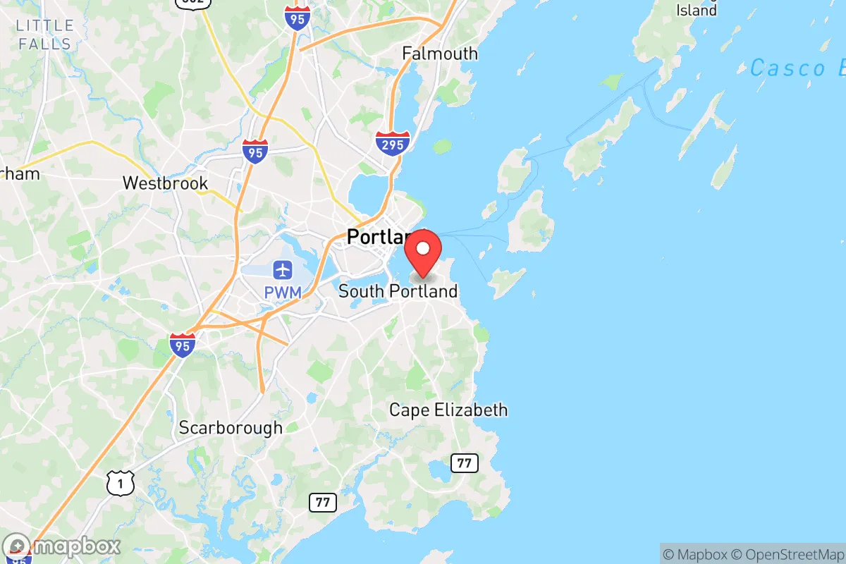
Regional Safe Places
Below is our recommended "safe zones" in Maine and the surrounding area based on our strategic heuristics. For most people, it's unrealistic to live in a “safe zone” full-time due to work, family or other personal reasons. They tend to be more rural. However, many of these areas are perfect for second homes and retreat properties that double as a vacation home or even a short-term rental.


Important Note: For informational purposes only. This does not mean nothing bad ever happens in the green zones. Please use common sense. This is based on public data and modeled with AI. We tried to take a conservative approach but mistakes happen. We update this regularly as new information becomes available.
Solar Generator Recommendations
Backup power matters more here than in safer locations. We've picked three solar generators across budgets and capacity tiers — start with the budget unit if you only need a few essentials, or step up if you want to run a fridge and HVAC for days at a time.

Jackery Portable Power Station Explorer 300
Budget OptionPower on the Go: Weighing only 11 lbs, it's convenient to set up and store with book-sized foldable solar panels

BLUETTI Portable Power Station AC180
Designed for both indoor and outdoor scenarios, AC180 is highly capable as it has a robost capacity and continuous output power.

EF ECOFLOW DELTA Pro Ultra Power Station
Upgraded PickEcoFlow DELTA Pro Ultra is a whole-home energy system designed to grow with your family. Integrated with the Smart Home Panel 2, it scales to meet your evolving energy needs — keeping your home powered, intelligent, and secure through every stage of life.
We earn a commission, at no additional cost to you.
Strategic Assessment Analysis
South Portland, Maine, presents a layered strategic picture for the conservative prepper or survivalist. Its resilience is a double-edged sword: the city benefits from a robust local economy and a strong sense of community, but its proximity to Portland and the coast introduces significant vulnerabilities. For a relocator prioritizing self-sufficiency and security, South Portland offers a solid foundation, but only if you understand and mitigate the specific risks tied to its geography and regional dependencies. The key is to leverage its advantages while building a buffer against the threats that come with being a satellite of a major urban and military hub.
Geographic position and natural advantages for long-term security
South Portland’s location on a peninsula jutting into Casco Bay is both a blessing and a strategic calculation. The city sits directly across the Fore River from Portland, connected by bridges that are chokepoints in any crisis scenario. The natural advantages are real: access to the Atlantic for fishing and maritime trade, a temperate climate that supports four-season living, and a topography that includes rocky coastlines, tidal rivers, and inland forested areas. The area is not prone to earthquakes, hurricanes rarely make direct landfall with full force, and the risk of wildfires is low compared to the West. The growing season is short—roughly 140 days—but the soil in the surrounding Cumberland County is workable for small-scale agriculture, especially if you invest in raised beds and cold frames. The real strategic value lies in the region’s water abundance: the Presumpscot River and numerous smaller streams provide freshwater, and the city’s water utility draws from Sebago Lake, a massive, protected reservoir. For a relocator, this means you are unlikely to face a water crisis in a drought scenario, but you must still plan for contamination or infrastructure failure. The coastal position also offers a potential escape route by water, though that requires a boat and the skills to navigate the often-foggy, rocky coastline.
Risks, exposures, and proximity to fallout-relevant landmarks
This is where the analysis gets serious. South Portland’s biggest strategic weakness is its proximity to Portland, a city of roughly 68,000 that swells with tourists and commuters. In a scenario of civil unrest, mass casualty events, or a breakdown of order, Portland becomes a liability. The bridges connecting South Portland to Portland—the Casco Bay Bridge and the Million Dollar Bridge—are obvious chokepoints that could be blocked, contested, or destroyed. The city is also within the blast and fallout radius of the Portsmouth Naval Shipyard in Kittery, about 30 miles south, which is a high-value target for any adversary. The shipyard works on nuclear submarines, and while the risk of an accidental detonation is low, the facility is a prime target for sabotage or a precision strike. Additionally, the Portland International Jetport is just a few miles away, and the city’s deepwater port handles commercial shipping, including fuel and cargo. In a national emergency, these become magnets for chaos. The population density in South Portland itself is moderate—about 8,500 people per square mile—but the city is built out with suburban sprawl, meaning there are few true rural refuges within walking distance. The biggest risk is being trapped in a gridlocked evacuation if something happens in Portland or at the shipyard. For the prepper, this means you need a plan that does not rely on the bridges or major highways. A secondary risk is the region’s dependence on tourism and service industries; a prolonged economic collapse would hit South Portland hard, as many residents work in hospitality, retail, and healthcare tied to the Portland metro economy.
Practical resilience for a relocator: food, water, energy, and defensibility
Let’s break down the practicalities. Food: South Portland has a few small farms and community gardens, but you cannot rely on local agriculture for year-round sustenance. The nearest reliable food production is in the inland towns of Gorham, Standish, and Windham, which are 15-30 minutes away. For a relocator, the smart play is to buy a property with at least a half-acre of land for a garden, chickens, and possibly a small greenhouse. The local farmers’ markets are good for supplementing, but they will be among the first things to disappear in a crisis. Water: As mentioned, the water supply from Sebago Lake is excellent, but the treatment plant and distribution lines are vulnerable to sabotage or contamination. You need a backup: a well on your property (if possible), rainwater catchment, or a supply of purification tablets and filters. The Presumpscot River is a viable source, but it runs through industrial areas, so testing is essential. Energy: The grid in South Portland is reasonably reliable, but it is tied to the New England power system, which has faced strain during extreme weather. Solar is a good option, but the region gets only about 200 sunny days per year, so you need battery storage and a backup generator—preferably one that runs on propane or diesel, which you can store. Natural gas is available in the city, but the pipeline infrastructure is a single point of failure. Defensibility: South Portland is not a defensible location in the traditional sense. It is a suburban city with open streets, few natural barriers, and a police force that would be overwhelmed in a widespread crisis. The best you can do is choose a home on a dead-end street, near a wooded area, or with a clear line of sight to approaches. The city’s proximity to the coast also means you are exposed to maritime threats—piracy or smuggling operations could use the bay as a staging ground. For a single individual or a family, the defensibility is moderate at best; you are better off looking at the rural towns inland, like Buxton or Limington, if security is your top priority. However, if you must be in South Portland for work or family, the key is to build a network of trusted neighbors and establish a cache of supplies that does not rely on the local grocery stores or gas stations.
The overall strategic picture for South Portland is one of calculated risk. It is not a bug-out location or a fortress, but it can be a viable home base if you are willing to put in the work. The city’s strengths—water abundance, a stable local economy, and a community that is generally self-reliant—are real. But the weaknesses—proximity to Portland, the naval shipyard, and the coast’s inherent exposure—are equally real. For the conservative prepper, the smartest approach is to treat South Portland as a hub for resources and income, while maintaining a secondary location inland that is more defensible and self-sufficient. If you are single and mobile, you can make it work with a well-stocked apartment and a vehicle ready to go. If you have a family, you need a property with land, a well, and a plan that does not depend on the bridges or the jetport. South Portland is a place to live strategically, not a place to hide. It offers a decent quality of life and a solid foundation for resilience, but only if you acknowledge the risks and build your preparations accordingly. The bottom line: it is a good option for the prepared, but a dangerous one for the complacent.
* Values derived from national, state, county, city and local statistics and may differ in a specific area. Last updated: 2026-05-02T01:37:09.000Z
Narrative content on this page is AI-generated and may contain mistakes. Verify any details that matter before acting on them.
ReloMaps may earn a commission from affiliate links at no extra cost to you.