
Photo: Wikipedia
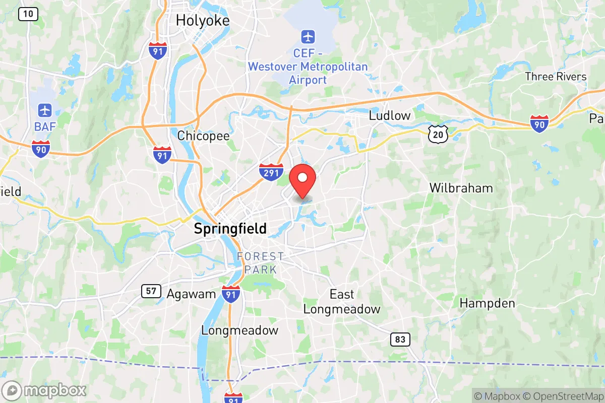
Strategic Assessment of Springfield, MA
Multiple tactical vulnerabilities. Population density, target proximity, or disaster risk are likely compounding. A retreat property and exit planning is required.
What does the Strategic Assessment tell us?
Our Strategic Assessment grades tactical survivability of an area. Major population centers, military targets, fallout zones, natural disasters, and border exposure all drive risk — lower exposure means a more defensible position in a crisis.
This is heavily inspired by Joel Skousen's Strategic Relocation book. Highly recommended you checkout the book ($)What does this tell us?
Our Strategic Assessment grades tactical survivability of an area. Major population centers, military targets, fallout zones, natural disasters, and border exposure all drive risk — lower exposure means a more defensible position in a crisis.
This is heavily inspired by Joel Skousen's Strategic Relocation book. Highly recommended you checkout the book ($)Strategic Pillars

Key Distances
Regional Safe Places
Below is our recommended "safe zones" in Massachusetts and the surrounding area based on our strategic heuristics. For most people, it's unrealistic to live in a “safe zone” full-time due to work, family or other personal reasons. They tend to be more rural. However, many of these areas are perfect for second homes and retreat properties that double as a vacation home or even a short-term rental.


Important Note: For informational purposes only. This does not mean nothing bad ever happens in the green zones. Please use common sense. This is based on public data and modeled with AI. We tried to take a conservative approach but mistakes happen. We update this regularly as new information becomes available.
Solar Generator Recommendations
Backup power matters more here than in safer locations. We've picked three solar generators across budgets and capacity tiers — start with the budget unit if you only need a few essentials, or step up if you want to run a fridge and HVAC for days at a time.

Jackery Portable Power Station Explorer 300
Budget OptionPower on the Go: Weighing only 11 lbs, it's convenient to set up and store with book-sized foldable solar panels

BLUETTI Portable Power Station AC180
Designed for both indoor and outdoor scenarios, AC180 is highly capable as it has a robost capacity and continuous output power.

EF ECOFLOW DELTA Pro Ultra Power Station
Upgraded PickEcoFlow DELTA Pro Ultra is a whole-home energy system designed to grow with your family. Integrated with the Smart Home Panel 2, it scales to meet your evolving energy needs — keeping your home powered, intelligent, and secure through every stage of life.
We earn a commission, at no additional cost to you.
Strategic Assessment Analysis
Springfield, Massachusetts, sits at a strategic crossroads in the Northeast corridor, but for a prepper or survivalist, its value is a double-edged sword. The city itself offers a dense population center with all the vulnerabilities that entails, yet its position along the Connecticut River and within a day’s drive of major metro areas like Boston, New York, and Albany creates a unique set of risks and limited opportunities for those seeking long-term resilience. The key is understanding that Springfield is not a bug-out destination but a potential staging ground or a place to avoid entirely, depending on your specific threat model and timeline.
Geographic position and natural advantages for a prepper
Springfield sits in the Connecticut River Valley, a fertile floodplain that historically made it an agricultural hub. For a prepper, this means access to some of the best soil in New England, with nearby farms in the Pioneer Valley producing everything from tobacco to vegetables. The river itself is a reliable water source, though it requires significant filtration and treatment due to industrial and agricultural runoff. The surrounding terrain is a mix of rolling hills and forested ridges, offering limited defensible positions but plenty of cover for those who know how to use it. The city’s elevation is low—around 80 feet above sea level—which means flooding is a real concern during heavy rains or a prolonged power grid failure that disables pumping stations. The climate is classic New England: cold, snowy winters that can be brutal without grid power, and humid summers that make long-term food storage a challenge without proper root cellaring or solar-powered refrigeration. The natural advantages here are real but require significant preparation to exploit—this isn’t a place you can show up empty-handed and expect to thrive.
Risks, exposures, and proximity to fallout-relevant landmarks
The biggest red flag for a survivalist considering Springfield is its proximity to multiple high-value targets. The city is roughly 90 miles from Boston, 150 miles from New York City, and 30 miles from the Hartford-New Haven metro area. In a mass casualty event or a major geopolitical crisis, these population centers become immediate fallout zones—both literal and figurative. The Bradley Air National Guard Base in Windsor Locks, Connecticut, is just 20 miles south, and Westover Air Reserve Base in Chicopee is only 10 miles east. Both are potential targets in a conventional or nuclear conflict. Additionally, the Connecticut River itself is a major transportation corridor for hazardous materials, including oil, natural gas, and chemicals, which could become secondary hazards if infrastructure fails. The city’s own industrial history, including old manufacturing sites and rail yards, means there are localized contamination risks from lead, PCBs, and other legacy pollutants. For a prepper, the calculus is clear: Springfield is within the blast radius of multiple potential targets, and the fallout—both radioactive and societal—would be severe. The city’s population density of over 150,000 people within a small footprint makes it a nightmare scenario for civil unrest, resource competition, and disease spread in a grid-down situation.
Practical resilience for a relocator: food, water, energy, and defensibility
For someone actually relocating to the Springfield area with a prepper mindset, the practical realities are sobering. The city’s water supply comes from the Springfield Water and Sewer Commission, which relies on the Cobble Mountain Reservoir and the Little River system. This is a surface water source, meaning it’s vulnerable to contamination from upstream spills, sabotage, or a prolonged power outage that disables treatment plants. A well on private property outside the city limits is a far better bet, but the local geology is a mix of glacial till and bedrock, making well drilling expensive and unpredictable. Food security is a mixed bag: the Pioneer Valley has a strong local food movement, with farmers’ markets and CSAs, but the growing season is short (roughly May to October), and the soil requires amendment for serious production. For long-term storage, the humid summers make it tough to keep grains and dried goods without climate-controlled space. Energy is the biggest vulnerability. The local grid is aging and prone to outages during winter storms and summer heat waves. Solar is viable but requires battery storage for the long, dark New England winters. Natural gas is common for heating, but that infrastructure is fragile in a crisis. Defensibility is poor within the city limits—dense neighborhoods, limited escape routes, and a high crime rate (Springfield consistently ranks among the most dangerous cities in Massachusetts) mean you’re better off looking at the rural towns to the west, like Granby, Belchertown, or Palmer. These areas offer more land, better water access, and lower population density, but they also come with their own challenges: limited medical facilities, longer travel times to supplies, and a local culture that can be insular. For a single individual or a family, the key is to avoid the city center entirely and focus on a property with a well, a septic system, and a defensible perimeter—preferably on a dead-end road with good sightlines.
The overall strategic picture for Springfield is one of high risk with limited reward for the serious prepper. The city’s location in the Connecticut River Valley offers natural resources and agricultural potential, but those benefits are overshadowed by its proximity to major metro areas, military installations, and industrial hazards. For someone looking to ride out a short-term crisis—say, a week-long power outage or a localized civil unrest event—the area’s infrastructure and community networks might provide a buffer. But for a long-term collapse scenario, the vulnerabilities are too numerous to ignore. The best use of Springfield in a prepper’s plan is as a resupply point or a temporary staging area before moving to a more defensible location in the rural hill towns to the west or north. If you’re considering a permanent relocation here, you need to be honest with yourself about the trade-offs: you’ll have access to some of the best soil and water in New England, but you’ll also be living in the shadow of multiple potential fallout zones. The smart move is to buy land outside the city, build your infrastructure before the crisis hits, and treat Springfield as a resource to be exploited, not a home to be defended. That’s the cold calculus of survival in the Northeast corridor.
* Values derived from national, state, county, city and local statistics and may differ in a specific area. Last updated: 2026-05-01T21:25:33.000Z
Narrative content on this page is AI-generated and may contain mistakes. Verify any details that matter before acting on them.
ReloMaps may earn a commission from affiliate links at no extra cost to you.