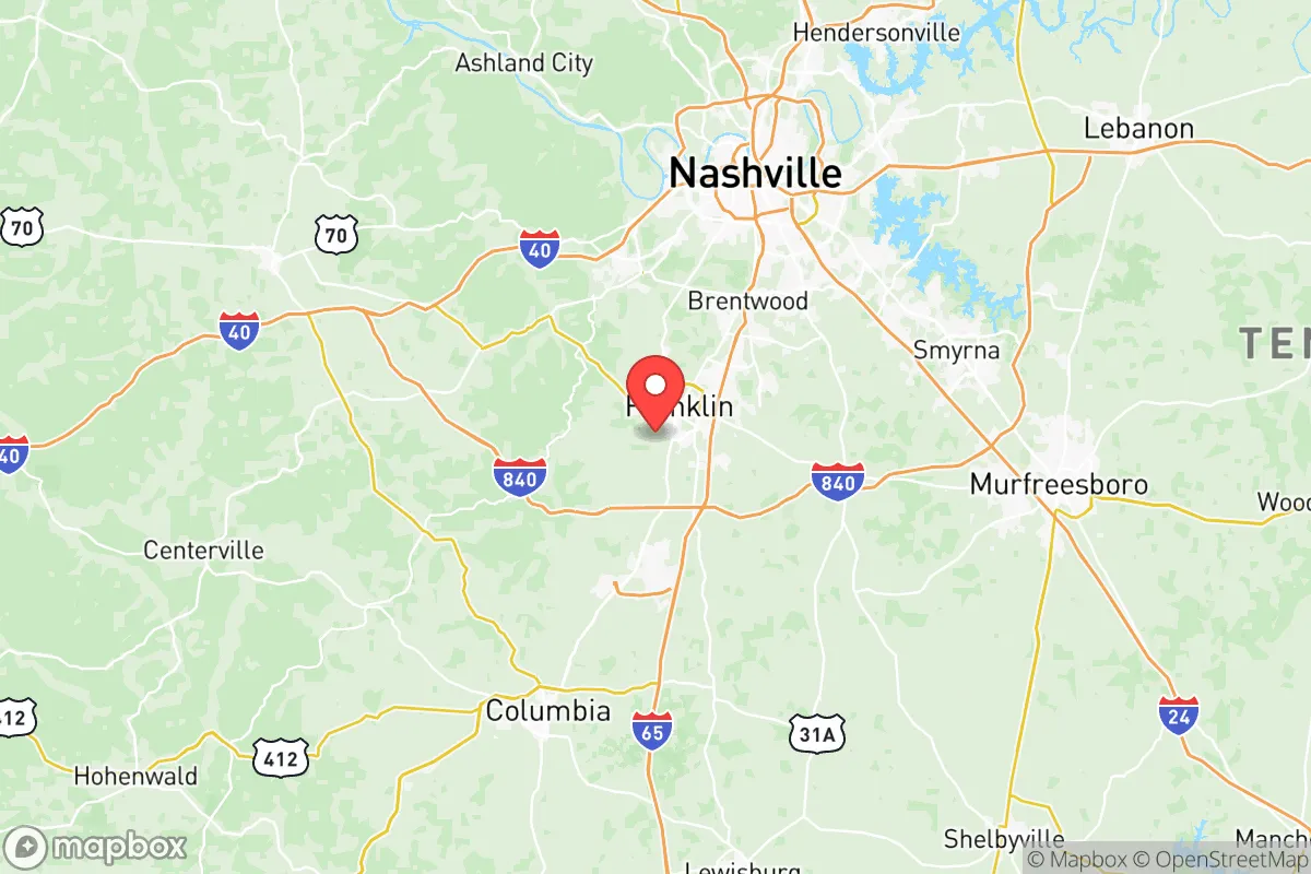
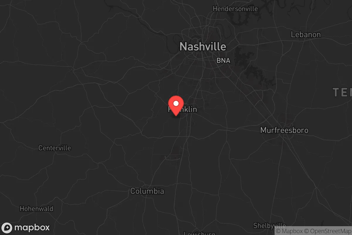
Strategic Assessment of Williamson County
Meaningful friction. Expect exposure to either population pressure, blast zones, or natural disaster risk. Consider buying a retreat property.
What does the Strategic Assessment tell us?
Our Strategic Assessment grades tactical survivability of an area. Major population centers, military targets, fallout zones, natural disasters, and border exposure all drive risk — lower exposure means a more defensible position in a crisis.
This is heavily inspired by Joel Skousen's Strategic Relocation book. Highly recommended you checkout the book ($)What does this tell us?
Our Strategic Assessment grades tactical survivability of an area. Major population centers, military targets, fallout zones, natural disasters, and border exposure all drive risk — lower exposure means a more defensible position in a crisis.
This is heavily inspired by Joel Skousen's Strategic Relocation book. Highly recommended you checkout the book ($)Strategic Pillars

Key Distances
Strategic Assessment Analysis
Williamson County, Tennessee, sits in a sweet spot that few other places in the Southeast can match: close enough to a major metro for supply runs and medical access, but far enough from the blast radius of a Nashville-scale event to offer genuine strategic depth. The county’s resilience isn’t an accident—it’s baked into its geography, infrastructure, and the kind of self-reliant culture that still exists in parts of the rural South. For a relocator thinking in terms of decades, not just next year’s commute, this area deserves a hard look.
Geographic position and natural advantages for long-term security
Williamson County anchors the southern edge of the Nashville metropolitan area, but its real value lies in what’s not there. The county sits atop the Highland Rim, a plateau that rises several hundred feet above the Nashville Basin. That elevation means less flood risk, better drainage, and—critically—a natural vantage point. The Harpeth River runs through the county, but its floodplains are narrow and well-defined; the vast majority of developable land is on stable, well-drained limestone bedrock. Franklin, the county seat, is roughly 20 miles south of downtown Nashville, which puts it outside the most severe fallout zones for a Nashville-centric event while still being close enough to reach the city’s hospitals and supply chains within an hour. Brentwood, Thompson’s Station, and Spring Hill offer similar buffers, with Spring Hill being particularly interesting because it straddles the Maury County line and gives you a secondary escape route south toward the Alabama line. The county’s position along Interstate 65 is a double-edged sword—it’s a major evacuation corridor, but it also means you can move north-south quickly if needed. The real natural advantage, though, is water: the Harpeth River, the Little Harpeth, and numerous creeks and springs provide surface water sources that aren’t dependent on municipal treatment plants. For a prepper, that’s the difference between a bug-out plan and a bug-in plan.
Risks, exposures, and proximity to fallout-relevant landmarks
No place is immune, and Williamson County has its share of liabilities. The biggest risk is proximity to Nashville’s infrastructure: Nashville International Airport (BNA) is about 25 miles north of Franklin, and while that’s outside the immediate blast zone for a conventional attack, it’s within the fallout footprint for a radiological event depending on wind direction. The Tennessee Valley Authority’s (TVA) Gallatin Fossil Plant and the Cumberland River industrial corridor are roughly 40 miles northeast—again, not a direct threat, but worth noting if you’re mapping fallout plumes. More immediate: Interstate 65 runs right through the heart of the county, and a major accident or deliberate blockage at the Saturn Parkway interchange in Spring Hill could cut off the primary north-south route. The county also has a natural gas pipeline corridor that runs roughly parallel to I-65; a rupture or sabotage event would be localized but disruptive. On the plus side, there are no major refineries, nuclear power plants, or chemical weapons depots within 50 miles. The closest military installation of note is Fort Campbell (about 70 miles northwest), which is a net positive—it means a rapid-response capability within a few hours’ drive, but it’s far enough that you won’t be in the immediate fallout zone if something goes wrong there. The Brentwood area, with its dense suburban development, is the most vulnerable to civil unrest because of its wealth concentration and proximity to Nashville’s urban core. Thompson’s Station and Fairview (in adjacent Hickman County) offer more rural buffer.
Practical resilience for a relocator: food, water, energy, and defensibility
This is where Williamson County shines for the serious prepper. Water: the county has multiple independent water systems beyond the Nashville metro’s supply. The Harpeth River is perennial and generally clean upstream of Franklin, and there are dozens of private wells in the rural areas south of Leiper’s Fork and east of Arrington. If you buy land with a well, you’re not dependent on municipal treatment plants that could be knocked out by a cyberattack or grid failure. Food: the county is still home to working farms, particularly in the southern half. The Williamson County Farmers Market in Franklin is a hub, but the real value is the network of small producers—pasture-raised beef, poultry, and vegetable operations—that aren’t tied to the industrial food system. You can buy a side of beef from a local rancher and freeze it for a year. Energy: the grid is reliable by national standards, but the county has a growing number of solar installations, and many rural properties already have propane tanks and generators. The Middle Tennessee Electric Membership Corporation (MTEMC) covers most of the county and has a strong co-op structure, which means less bureaucratic friction if you want to add solar or battery storage. Defensibility: the terrain is rolling hills with plenty of tree cover, especially in the Narrows of the Harpeth area near Kingston Springs. That makes it hard to approach unseen, and the rural road network—while not extensive—offers multiple egress routes if I-65 is blocked. The county’s law enforcement presence is robust, with the Williamson County Sheriff’s Office and local police departments in Franklin, Brentwood, and Spring Hill. In a prolonged crisis, the community’s existing social fabric—churches, civic groups, and a strong volunteer fire department culture—would be a force multiplier for mutual aid.
The overall strategic picture for Williamson County is one of calculated advantage. It’s not a remote bunker in the mountains, and it’s not a fortified compound—it’s a place where you can live a normal life while maintaining the ability to weather a serious disruption. The proximity to Nashville gives you access to medical centers, supply chains, and a labor market, but the county’s own resources—water, farmland, and a self-reliant population—mean you’re not dependent on the city. The risks are real but manageable: avoid the densest suburbs like Brentwood if you’re worried about civil unrest, and buy land with a well and a septic system south of Franklin or in the Thompson’s Station area. For a conservative-leaning relocator who wants to be prepared without living off-grid, this is one of the best options in the Southeast. The key is to get in before the secret gets out—because once the next crisis hits, everyone else will be looking at the same map.
* Values derived from national, state, county, city and local statistics and may differ in a specific area. Last updated: 2026-05-09T18:49:04.000Z
Narrative content on this page is AI-generated and may contain mistakes. Verify any details that matter before acting on them.
ReloMaps may earn a commission from affiliate links at no extra cost to you.