Photo: Wikipedia
Strategic Assessment of Collin County
Meaningful friction. Expect exposure to either population pressure, blast zones, or natural disaster risk. Consider buying a retreat property.
What does the Strategic Assessment tell us?
Our Strategic Assessment grades tactical survivability of an area. Major population centers, military targets, fallout zones, natural disasters, and border exposure all drive risk — lower exposure means a more defensible position in a crisis.
This is heavily inspired by Joel Skousen's Strategic Relocation book. Highly recommended you checkout the book ($)What does this tell us?
Our Strategic Assessment grades tactical survivability of an area. Major population centers, military targets, fallout zones, natural disasters, and border exposure all drive risk — lower exposure means a more defensible position in a crisis.
This is heavily inspired by Joel Skousen's Strategic Relocation book. Highly recommended you checkout the book ($)Strategic Pillars

Key Distances
Strategic Assessment Analysis
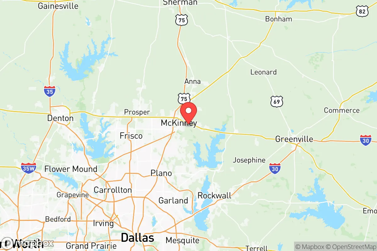
Collin County, Texas, offers a strategic blend of economic resilience and geographic positioning that appeals to those prioritizing long-term stability and preparedness. Located just north of Dallas, the county benefits from a robust job market anchored by major employers like Toyota North America, JPMorgan Chase, and Raytheon, while its location along the U.S. 75 and Sam Rayburn Tollway corridors provides rapid access to the broader North Texas region. For a conservative-leaning relocator concerned with civic stability, the area’s strong local governance, low property tax rates relative to surrounding counties, and a population that leans heavily Republican—with Collin County voting +18 R in the 2024 presidential election—signal a community aligned with self-reliance and limited government. However, its proximity to the Dallas-Fort Worth metroplex introduces both opportunities and vulnerabilities that require careful assessment for those planning for worst-case scenarios.
Geographic position and natural advantages for long-term stability
Collin County sits on the Blackland Prairie, a region of fertile soil and relatively flat terrain that historically supported agriculture, but its modern advantage lies in its position away from major fault lines, hurricane-prone coasts, and floodplains. Unlike Houston or Galveston, the county is over 200 miles inland, reducing exposure to storm surges and hurricane-force winds. The area’s elevation averages around 600 feet, with gentle slopes that minimize landslide risks. Natural water sources include the East Fork of the Trinity River and Lake Lavon, a 21,000-acre reservoir that supplies drinking water to much of the county. For a prepper, this means a reliable surface water source within a 30-minute drive from most points in McKinney or Plano, though access is controlled by municipal utilities. The county’s position also places it roughly 150 miles from Fort Hood (now Fort Cavazos), a major Army base that could serve as a logistical hub during federal emergencies, but also as a potential target. The lack of significant natural barriers—no mountains, dense forests, or large rivers—means the terrain is easily traversable, which is a double-edged sword for defensibility.
Risks, exposures, and proximity to fallout-relevant landmarks
The primary strategic risk for Collin County is its proximity to the Dallas-Fort Worth metroplex, a population center of over 7.5 million people that includes critical infrastructure like Dallas/Fort Worth International Airport (DFW), a major transit hub for military and commercial aviation. In a mass casualty event or civil unrest scenario, this density could create choke points on highways like I-35E and U.S. 75, which run through the county’s western and eastern edges. More concerning for a survivalist is the presence of the Valero Refinery in nearby McKinney—though it’s a smaller facility—and the larger ExxonMobil refinery in Beaumont, about 250 miles southeast, which could be a secondary fallout concern if targeted. Within Collin County itself, the Texas Instruments semiconductor plant in Richardson (just south of the county line) and the Raytheon facility in McKinney are potential targets for cyber or physical attacks, given their defense-contractor roles. The county also hosts the Collin County Regional Airport, a general aviation field that could be used for evacuation or supply drops, but also monitored by federal agencies. For those worried about nuclear fallout, the county’s flat terrain offers little shielding, and prevailing winds from the south could carry fallout from a strike on the Dallas metroplex directly into the area. The nearest significant military target is the Naval Air Station Joint Reserve Base Fort Worth, about 50 miles southwest, which houses F-16s and C-130s.
Practical resilience for a relocator: food, water, energy, and defensibility
For a relocator focused on self-sufficiency, Collin County presents a mixed picture. Water access is the strongest point: Lake Lavon and the Trinity River provide raw water sources, but most residential areas rely on municipal supplies from the North Texas Municipal Water District, which could be disrupted during a grid failure. Drilling a private well is feasible in rural parts of the county, like around Anna or Blue Ridge, where water tables sit at 50-100 feet, but urban areas like Frisco and Allen have restrictive well ordinances. Food resilience is moderate—the county has a growing number of small farms and farmers markets, particularly in Celina and Princeton, but the soil is heavy clay, requiring amendment for serious gardening. Local food production is not enough to sustain the population during a supply chain collapse; most groceries come from distribution centers in Dallas. Energy-wise, the county is part of the ERCOT grid, which has proven vulnerable to winter storms (e.g., 2021’s Winter Storm Uri). Solar adoption is increasing, but many subdivisions have HOA restrictions on panels. For defensibility, the county’s suburban sprawl—with cul-de-sacs and master-planned communities—offers natural chokepoints for neighborhood security, but the lack of rural buffer zones means a determined group could move through quickly. The county sheriff’s office is well-funded and has a strong relationship with local gun clubs, which could be an asset for community defense networks. The presence of multiple gun ranges, like the Elm Fork Shooting Sports in nearby Dallas, and a high rate of concealed carry permits (Texas is a constitutional carry state) suggest a population that is armed and potentially organized.
Overall, Collin County offers a strategic sweet spot for the conservative prepper: it’s close enough to urban resources to build wealth and networks, but far enough from the most obvious targets to provide a buffer. The county’s strong economy, conservative governance, and access to water and arable land make it a viable base for long-term resilience planning. However, the risks from its proximity to Dallas-Fort Worth, the flat terrain, and the reliance on fragile infrastructure mean that a relocator must invest in off-grid capabilities—solar, well water, food storage, and community ties—to truly capitalize on the area’s advantages. For those willing to put in the work, Collin County is a solid anchor point in a volatile world, but it’s not a bug-out location; it’s a place to build a sustainable, defensible life while the storm clouds gather.
* Values derived from national, state, county, city and local statistics and may differ in a specific area. Last updated: 2026-05-11T23:51:11.000Z
Narrative content on this page is AI-generated and may contain mistakes. Verify any details that matter before acting on them.
ReloMaps may earn a commission from affiliate links at no extra cost to you.