
Photo: Wikipedia
Strategic Assessment of Unalakleet, AK
Strong survivability profile. Good buffer from population centers, with manageable environmental and tactical risks.
What does the Strategic Assessment tell us?
Our Strategic Assessment grades tactical survivability of an area. Major population centers, military targets, fallout zones, natural disasters, and border exposure all drive risk — lower exposure means a more defensible position in a crisis.
This is heavily inspired by Joel Skousen's Strategic Relocation book. Highly recommended you checkout the book ($)What does this tell us?
Our Strategic Assessment grades tactical survivability of an area. Major population centers, military targets, fallout zones, natural disasters, and border exposure all drive risk — lower exposure means a more defensible position in a crisis.
This is heavily inspired by Joel Skousen's Strategic Relocation book. Highly recommended you checkout the book ($)Strategic Pillars

Key Distances
Regional Safe Places
Below is our recommended "safe zones" in Alaska and the surrounding area based on our strategic heuristics. For most people, it's unrealistic to live in a “safe zone” full-time due to work, family or other personal reasons. They tend to be more rural. However, many of these areas are perfect for second homes and retreat properties that double as a vacation home or even a short-term rental.
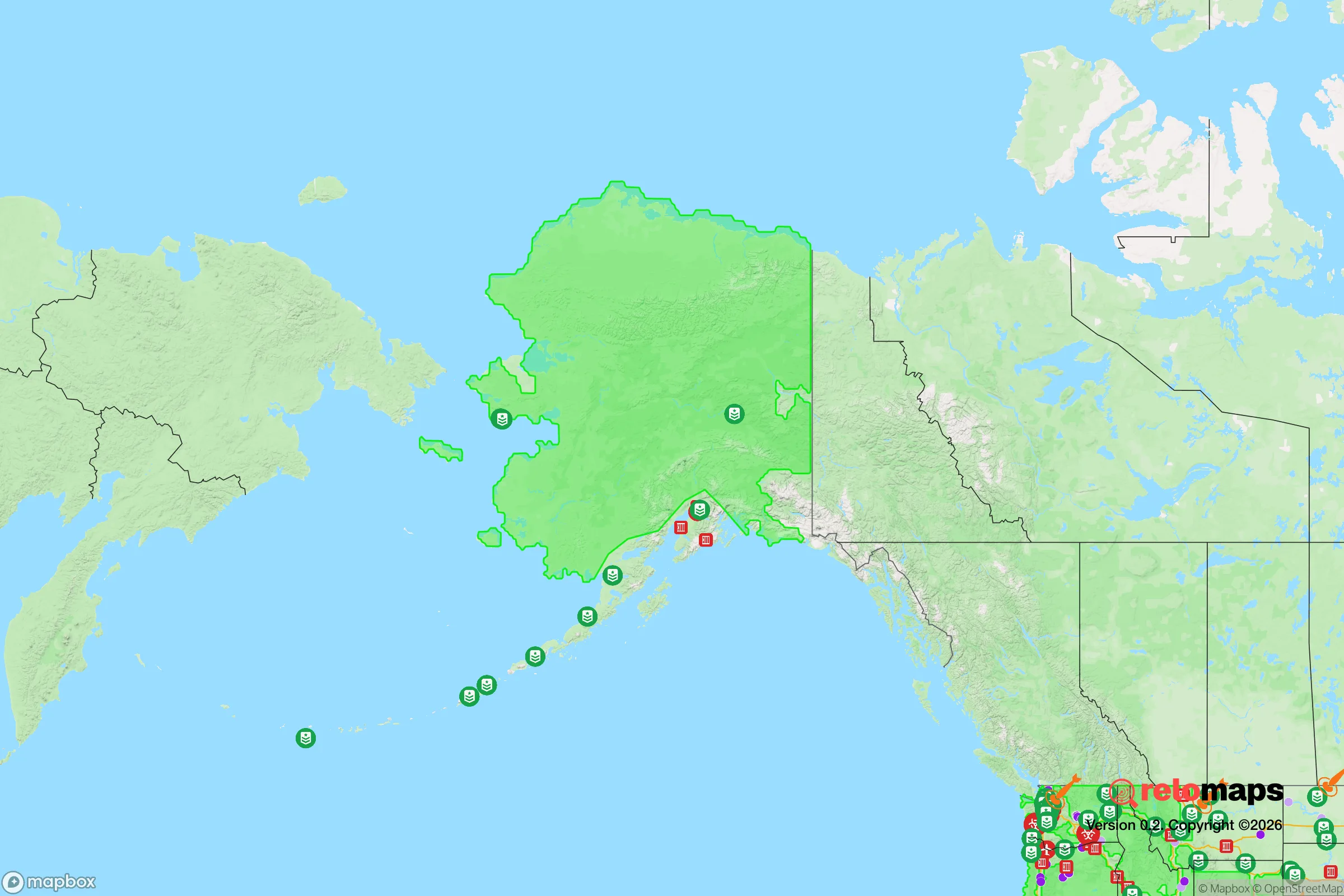
Important Note: For informational purposes only. This does not mean nothing bad ever happens in the green zones. Please use common sense. This is based on public data and modeled with AI. We tried to take a conservative approach but mistakes happen. We update this regularly as new information becomes available.
Solar Generator Recommendations
Backup power matters more here than in safer locations. We've picked three solar generators across budgets and capacity tiers — start with the budget unit if you only need a few essentials, or step up if you want to run a fridge and HVAC for days at a time.

Jackery Portable Power Station Explorer 300
Budget OptionPower on the Go: Weighing only 11 lbs, it's convenient to set up and store with book-sized foldable solar panels

BLUETTI Portable Power Station AC180
Designed for both indoor and outdoor scenarios, AC180 is highly capable as it has a robost capacity and continuous output power.

EF ECOFLOW DELTA Pro Ultra Power Station
Upgraded PickEcoFlow DELTA Pro Ultra is a whole-home energy system designed to grow with your family. Integrated with the Smart Home Panel 2, it scales to meet your evolving energy needs — keeping your home powered, intelligent, and secure through every stage of life.
We earn a commission, at no additional cost to you.
Strategic Assessment Analysis
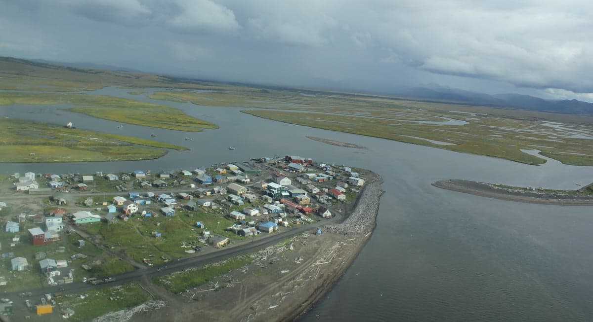
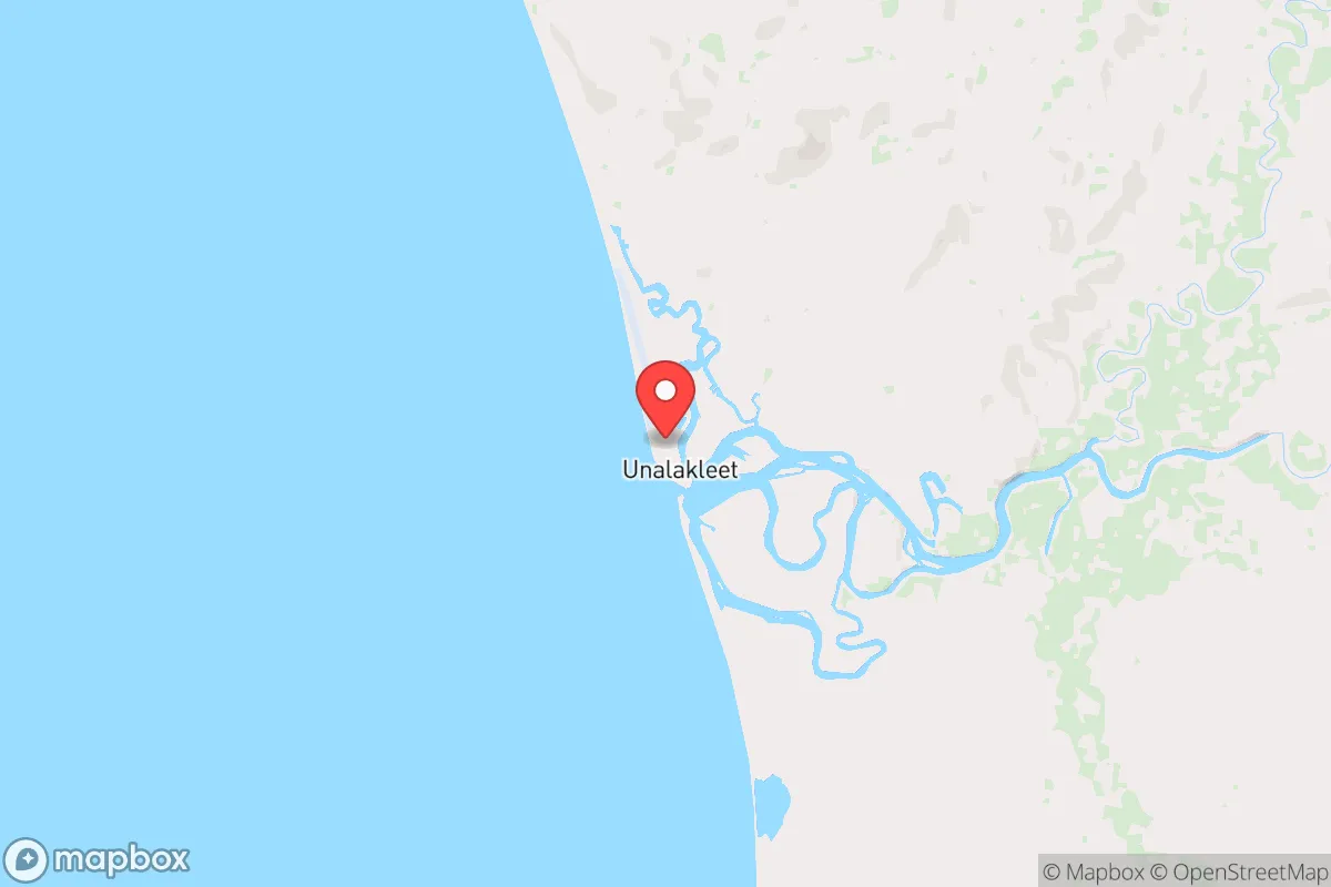
Unalakleet, a remote Iñupiaq village of roughly 700 people on the Norton Sound coast of western Alaska, offers a strategic relocation option for those prioritizing physical isolation, resource independence, and distance from the cascading risks of urban collapse. Its location—roughly 150 miles southeast of Nome and 400 miles west of Anchorage—places it far from any major population center, critical infrastructure targets, or nuclear fallout zones, while its status as a regional hub for subsistence and small-scale commerce provides a baseline of community function that many remote Alaskan villages lack. For a relocator with a prepper mindset, Unalakleet’s combination of extreme remoteness, harsh but manageable climate, and established local networks makes it a viable long-term fallback position, provided one accepts the trade-offs in access, cost, and lifestyle.
Geographic position and natural advantages for long-term survival
Unalakleet sits at the mouth of the Unalakleet River where it empties into the Norton Sound of the Bering Sea, giving it a dual advantage: access to marine resources and a riverine corridor into the interior. The surrounding terrain is a mix of tundra, low hills, and coastal flats, with no trees larger than stunted willows—meaning no forest fire risk and clear sightlines for security. The village lies roughly 60 miles south of the Arctic Circle, so summers bring 20+ hours of daylight for intensive food production and construction, while winters offer sea ice that can be used for travel and hunting. Critically, Unalakleet is over 350 miles from the nearest interstate highway system (the Alaska Highway in Canada) and has no road connection to the rest of North America; all access is by air or seasonal barge. This effectively eliminates the risk of refugee flows, looters, or military convoys passing through. The nearest city of any size is Nome (population ~3,600), which itself is a remote outpost, not a threat. For a relocator concerned with fallout from nuclear events, Unalakleet is roughly 1,200 miles downwind of the nearest major strategic targets (ICBM fields in the Dakotas, Pacific Northwest ports) and the prevailing winds blow from the north and east, meaning any fallout from a West Coast strike would be carried out to sea, not toward the village. The Bering Sea itself provides a buffer against any maritime threats, as the nearest foreign coast (Russia’s Chukotka Peninsula) is 200 miles across the water and largely uninhabited.
Risks, exposures, and proximity to fallout-relevant landmarks
While Unalakleet is far from the Lower 48’s target-rich environment, it is not without its own strategic vulnerabilities. The village sits within 100 miles of the Clear Air Force Station (a missile warning radar site) near Anderson, Alaska, though that facility is 300 miles to the east and not a primary nuclear target. More concerning is the Trans-Alaska Pipeline System, which runs roughly 200 miles east of Unalakleet; a disruption to the pipeline could trigger economic collapse in Anchorage and Fairbanks, but the village itself would be unaffected due to its isolation. The real risk is natural: Unalakleet lies in a seismically active zone, with the Denali Fault 150 miles to the east. A major earthquake could disrupt air and barge supply chains for months, but the village’s subsistence base (salmon, seal, caribou, berries) means starvation is unlikely. The Bering Sea coast is also vulnerable to storm surges and coastal erosion; the village has already lost several feet of shoreline in the past decade. For a relocator, the primary man-made risk is a disruption of aviation fuel supply—the village’s only reliable link to the outside world. If jet fuel stops arriving, evacuation or resupply becomes impossible except by small boat in summer or snowmachine in winter. This is a feature, not a bug, for those seeking to avoid outside interference, but it means you must be fully self-sufficient before any crisis hits.
Practical resilience for a relocator: food, water, energy, and defensibility
Unalakleet’s subsistence economy is the backbone of its resilience. The village’s residents harvest over 200 pounds of salmon per person annually from the Unalakleet River, plus seal, beluga whale, moose, caribou, and ptarmigan. Berries (blueberries, salmonberries, crowberries) are abundant on the tundra in late summer. For a relocator, this means you can supplement store-bought food indefinitely with local protein and produce, provided you learn the hunting and fishing methods. Fresh water comes from the Unalakleet River and local lakes; the village has a piped water system, but in a collapse scenario, you can haul water by hand or snowmachine. Electricity is generated by diesel generators, with fuel delivered by barge each summer. A relocator should plan for solar panels and a small wind turbine—the area averages 12-15 mph winds year-round, and summer daylight is near-constant. Heating is primarily by fuel oil or wood (though wood is scarce; you’d need to import it or burn driftwood). Defensibility is excellent: the village is compact (roughly 1 square mile), with only one airstrip and no road access. Any intruder would be visible from miles away on the open tundra. The local population is tight-knit and wary of outsiders; a relocator must build trust over years, not weeks. Crime is low—the Alaska State Troopers report fewer than 10 violent crimes per year in the entire Norton Sound region—but alcohol abuse and domestic issues exist, as in any isolated community. For a single individual or family, the key is to arrive with a year’s worth of supplies, a reliable snowmachine, and a willingness to learn Iñupiaq subsistence skills.
The overall strategic picture for Unalakleet is one of extreme isolation with a functional local economy, but it is not a bug-out location for the unprepared. It is a place for a relocator who can commit to a multi-year transition, learning the land and the culture before any crisis hits. The village’s distance from nuclear targets, its subsistence base, and its lack of road access make it one of the most defensible and self-sufficient locations in North America for those willing to trade modern convenience for security. The trade-offs are real: no Amazon delivery, no urgent care clinic (the nearest hospital is in Nome, a $400 flight away), and winters that drop to -40°F with 80 mph winds. But for someone who sees the coming decades as a period of systemic risk—whether from economic collapse, civil unrest, or geopolitical conflict—Unalakleet offers a hard but honest path. It is not a retreat; it is a forward position, built on the same principles that have sustained the Iñupiaq for thousands of years. If you can handle the cold and the isolation, it will handle you.
* Values derived from national, state, county, city and local statistics and may differ in a specific area. Last updated: 2026-04-19T19:39:39.000Z
Narrative content on this page is AI-generated and may contain mistakes. Verify any details that matter before acting on them.
ReloMaps may earn a commission from affiliate links at no extra cost to you.