
Photo: Wikipedia
Strategic Assessment of Warrenton, VA
Meaningful friction. Expect exposure to either population pressure, blast zones, or natural disaster risk. Consider buying a retreat property.
What does the Strategic Assessment tell us?
Our Strategic Assessment grades tactical survivability of an area. Major population centers, military targets, fallout zones, natural disasters, and border exposure all drive risk — lower exposure means a more defensible position in a crisis.
This is heavily inspired by Joel Skousen's Strategic Relocation book. Highly recommended you checkout the book ($)What does this tell us?
Our Strategic Assessment grades tactical survivability of an area. Major population centers, military targets, fallout zones, natural disasters, and border exposure all drive risk — lower exposure means a more defensible position in a crisis.
This is heavily inspired by Joel Skousen's Strategic Relocation book. Highly recommended you checkout the book ($)Strategic Pillars

Key Distances
Regional Safe Places
Below is our recommended "safe zones" in Virginia and the surrounding area based on our strategic heuristics. For most people, it's unrealistic to live in a “safe zone” full-time due to work, family or other personal reasons. They tend to be more rural. However, many of these areas are perfect for second homes and retreat properties that double as a vacation home or even a short-term rental.


Important Note: For informational purposes only. This does not mean nothing bad ever happens in the green zones. Please use common sense. This is based on public data and modeled with AI. We tried to take a conservative approach but mistakes happen. We update this regularly as new information becomes available.
Solar Generator Recommendations
Backup power matters more here than in safer locations. We've picked three solar generators across budgets and capacity tiers — start with the budget unit if you only need a few essentials, or step up if you want to run a fridge and HVAC for days at a time.

Jackery Portable Power Station Explorer 300
Budget OptionPower on the Go: Weighing only 11 lbs, it's convenient to set up and store with book-sized foldable solar panels

BLUETTI Portable Power Station AC180
Designed for both indoor and outdoor scenarios, AC180 is highly capable as it has a robost capacity and continuous output power.

EF ECOFLOW DELTA Pro Ultra Power Station
Upgraded PickEcoFlow DELTA Pro Ultra is a whole-home energy system designed to grow with your family. Integrated with the Smart Home Panel 2, it scales to meet your evolving energy needs — keeping your home powered, intelligent, and secure through every stage of life.
We earn a commission, at no additional cost to you.
Strategic Assessment Analysis
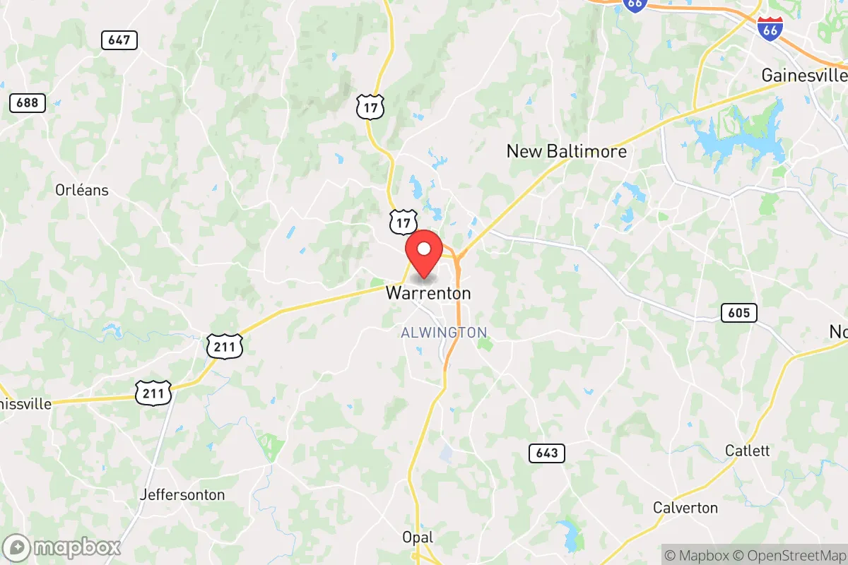
Warrenton, Virginia, offers a compelling strategic position for those prioritizing resilience and self-sufficiency, sitting roughly 45 miles southwest of Washington, D.C., yet retaining a distinctly rural character that buffers it from the immediate fallout of urban collapse. The town’s location in Fauquier County places it within the Piedmont region, a landscape of rolling hills, hardwood forests, and working farms that provide both natural resources and defensible terrain. For a relocator concerned with civic unrest, mass casualty events, or large-scale disasters, Warrenton’s combination of distance from primary targets, access to multiple evacuation routes, and a historically self-reliant population makes it a serious contender for a long-term base of operations.
Geographic position and natural advantages for long-term security
Warrenton’s primary strategic asset is its position along the I-66 corridor, which provides a direct but not overly exposed link to the D.C. metro area. While proximity to a major population center is generally a liability in a collapse scenario, Warrenton sits far enough out that it avoids the immediate blast radius of a nuclear strike on the capital—roughly 40 miles from the Pentagon and 50 miles from the White House. The area is also shielded by the Bull Run Mountains to the east and the Blue Ridge to the west, offering natural barriers that slow movement and provide cover. The Rappahannock River runs just south of town, a reliable water source that can support small-scale agriculture and livestock, while the surrounding forests offer timber for fuel and construction. Fauquier County’s agricultural zoning and conservation easements mean that much of the land remains undeveloped, reducing population density and preserving the kind of open space that allows for dispersed living—critical for avoiding disease spread and maintaining operational security in a prolonged crisis.
Risks, exposures, and proximity to fallout-relevant landmarks
The most significant downside to Warrenton is its unavoidable proximity to the D.C. metropolitan area, which makes it a secondary fallout zone in any major conflict involving the federal government. A nuclear detonation at the Pentagon or Capitol would send radioactive debris drifting southeast on prevailing winds, but Warrenton lies generally west-southwest of D.C., which mitigates some of that risk—though wind patterns vary, and a ground burst could still contaminate the region. Beyond nuclear threats, the I-66 corridor is a double-edged sword: it’s an evacuation route for D.C. residents fleeing a crisis, meaning Warrenton could see a wave of refugees within hours of a major event. The town itself is not a primary target—no major military bases, intelligence agencies, or critical infrastructure are located here—but it sits within 30 miles of Vint Hill Farms Station (a former NSA site) and 20 miles from the Manassas Regional Airport, which could be secondary targets. Natural disaster risks are low: the area sees occasional flooding along the Rappahannock, but it’s not in a hurricane zone, and tornadoes are rare. The biggest practical risk is a prolonged power grid failure, as the region is heavily dependent on the PJM Interconnection, and rural areas like Warrenton are often last to be restored.
Practical resilience for a relocator: food, water, energy, and defensibility
For a relocator serious about prepping, Warrenton offers several concrete advantages. Water is the first priority: the Rappahannock River and its tributaries (like Cedar Run and Licking Run) provide surface water, and the area’s groundwater table is accessible via shallow wells in most rural parcels—many older homes already have hand-dug wells or springs. Fauquier County has a strong agricultural tradition, with dozens of working farms producing beef, poultry, hay, and vegetables; a relocator with land can tap into local knowledge and barter networks for seeds, livestock, and equipment. The county also has a robust hunting culture—deer, turkey, and small game are abundant—and fishing in the Rappahannock is reliable. For energy, solar is viable: the region averages about 200 sunny days per year, and many rural properties already have backup generators or off-grid solar setups. Defensibility is moderate: the rolling hills and wooded ridges provide natural chokepoints, and the town’s layout—with a historic core surrounded by scattered farms—means a determined group could secure a perimeter around a small compound. However, the lack of a natural fortress (like a mountain pass or island) means you’d need to rely on community cooperation and early warning systems. The local population skews conservative and self-reliant, with a strong gun culture and a history of volunteer fire departments and emergency response teams—this is not a place where people wait for FEMA to show up.
The overall strategic picture for Warrenton is one of calculated trade-offs. It’s close enough to D.C. to be affected by a major event, but far enough to avoid the worst of the initial chaos, and its rural infrastructure and community mindset provide a foundation for long-term survival. The key weakness is the refugee risk from the I-66 corridor, which demands a plan for securing your property and establishing relationships with neighbors before a crisis hits. For a single individual or family willing to invest in off-grid water and power, and to build ties with the local farming and hunting community, Warrenton offers a realistic base for riding out a national-level disruption—not a fortress, but a defensible position with resources and people who know how to use them.
* Values derived from national, state, county, city and local statistics and may differ in a specific area. Last updated: 2026-05-01T16:56:39.000Z
Narrative content on this page is AI-generated and may contain mistakes. Verify any details that matter before acting on them.
ReloMaps may earn a commission from affiliate links at no extra cost to you.