 Popular
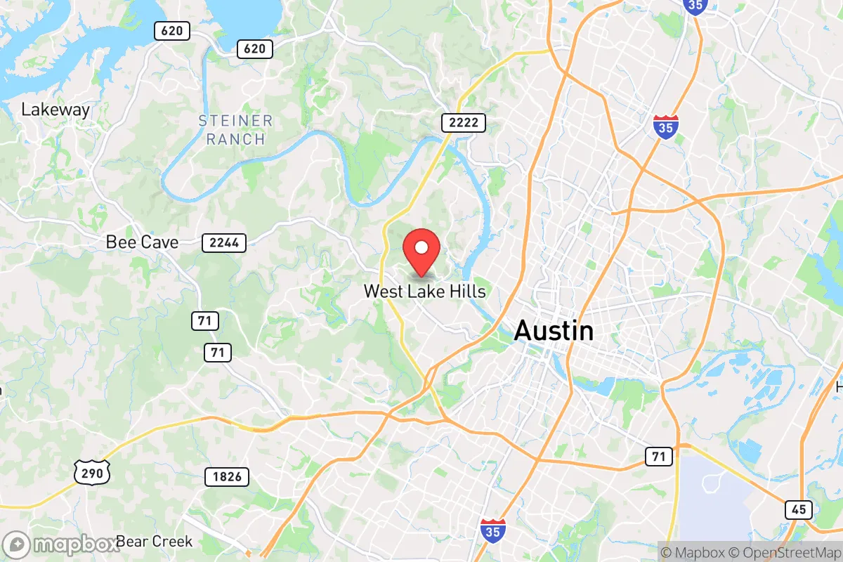
Strategic Assessment of West Lake Hills, TX
Multiple tactical vulnerabilities. Population density, target proximity, or disaster risk are likely compounding. A retreat property and exit planning is required.
What does the Strategic Assessment tell us?
Our Strategic Assessment grades tactical survivability of an area. Major population centers, military targets, fallout zones, natural disasters, and border exposure all drive risk — lower exposure means a more defensible position in a crisis.
This is heavily inspired by Joel Skousen's Strategic Relocation book. Highly recommended you checkout the book ($)What does this tell us?
Our Strategic Assessment grades tactical survivability of an area. Major population centers, military targets, fallout zones, natural disasters, and border exposure all drive risk — lower exposure means a more defensible position in a crisis.
This is heavily inspired by Joel Skousen's Strategic Relocation book. Highly recommended you checkout the book ($)Strategic Pillars

Key Distances
Regional Safe Places
Below is our recommended "safe zones" in Texas and the surrounding area based on our strategic heuristics. For most people, it's unrealistic to live in a “safe zone” full-time due to work, family or other personal reasons. They tend to be more rural. However, many of these areas are perfect for second homes and retreat properties that double as a vacation home or even a short-term rental.


Important Note: For informational purposes only. This does not mean nothing bad ever happens in the green zones. Please use common sense. This is based on public data and modeled with AI. We tried to take a conservative approach but mistakes happen. We update this regularly as new information becomes available.
Solar Generator Recommendations
Backup power matters more here than in safer locations. We've picked three solar generators across budgets and capacity tiers — start with the budget unit if you only need a few essentials, or step up if you want to run a fridge and HVAC for days at a time.

Jackery Portable Power Station Explorer 300
Budget OptionPower on the Go: Weighing only 11 lbs, it's convenient to set up and store with book-sized foldable solar panels

BLUETTI Portable Power Station AC180
Designed for both indoor and outdoor scenarios, AC180 is highly capable as it has a robost capacity and continuous output power.

EF ECOFLOW DELTA Pro Ultra Power Station
Upgraded PickEcoFlow DELTA Pro Ultra is a whole-home energy system designed to grow with your family. Integrated with the Smart Home Panel 2, it scales to meet your evolving energy needs — keeping your home powered, intelligent, and secure through every stage of life.
We earn a commission, at no additional cost to you.
Strategic Assessment Analysis
West Lake Hills, Texas, offers a rare combination of geographic insulation and logistical access that makes it a serious contender for strategic relocation, particularly for those prioritizing long-term resilience over convenience. Nestled in the Texas Hill Country just west of Austin, this small city of roughly 3,200 residents sits atop a series of limestone ridges that provide natural elevation, drainage advantages, and a degree of separation from the urban core. While its proximity to Austin introduces obvious risks in a major crisis, the specific layout, topography, and local governance structure of West Lake Hills create a defensible pocket that is far more survivable than most suburban enclaves within a major metro area.
Geographic position and natural defensive advantages
West Lake Hills occupies a strategic high-ground position along the Colorado River’s northern bank, with elevations ranging from 700 to over 1,000 feet above sea level. This elevation provides natural surveillance over the surrounding terrain and reduces the risk of flash flooding that plagues lower-lying parts of Austin. The area is bounded by the Barton Creek Greenbelt to the south and the Lake Austin reservoir to the north, creating a natural moat effect that limits vehicular approach routes to a handful of key chokepoints—primarily Bee Cave Road, Westlake Drive, and Redbud Trail. In a grid-down scenario or civil unrest event, these limited access points can be monitored or blocked with minimal manpower. The underlying geology is predominantly limestone and clay, which supports well water and septic systems, reducing dependency on municipal infrastructure. The local canopy of live oaks and junipers provides both concealment and a source of firewood, though it also increases wildfire risk during dry periods.
Risks, exposures, and proximity to fallout-relevant landmarks
The most significant vulnerability of West Lake Hills is its location roughly 8 miles west of downtown Austin, placing it within the blast and fallout radius of any major attack on the state capital or the University of Texas campus. Austin is a high-value target for both state-level and national adversaries, and the city’s population density—over 1 million in the metro area—creates a massive refugee flow risk. In a mass casualty event or civil unrest, West Lake Hills would face pressure from evacuees fleeing east along Highway 71 and Bee Cave Road. The nearby Austin-Bergstrom International Airport (15 miles east) and the large semiconductor manufacturing facilities in the region are additional secondary targets that could generate fallout or secondary effects. Wildfire is a real and recurring threat, with the 2011 Bastrop fire and the 2023 Spicewood fire demonstrating how quickly the Hill Country can burn. The area also sits in a moderate seismic zone, though earthquake risk is low compared to wildfire or flash flooding from intense storms. The local police force is small—around 15 officers—and relies heavily on Travis County Sheriff and Texas DPS for backup, which may be slow or absent during a widespread emergency.
Practical resilience for a relocator: food, water, energy, and defensibility
For a relocator serious about self-sufficiency, West Lake Hills offers a mixed but workable baseline. Water is the strongest asset: Lake Austin provides a massive, year-round freshwater reservoir, and many homes in the area have private wells that tap into the Trinity Aquifer. Rainwater catchment is legal and encouraged, with the city offering rebates for cistern systems. Food resilience is weaker—the area is zoned for large lots (minimum 1 acre in most of the city), but HOA restrictions and city ordinances limit livestock and large gardens. Backyard chickens are generally allowed, but goats, pigs, or cattle are not. The local farmers’ market in nearby Westlake Village is a good supplement but not a survival resource. Energy resilience is improving: solar adoption is growing, and the city has a net metering agreement with Austin Energy, but battery storage is still uncommon. Natural gas is widely available, which is useful for cooking and heating during grid outages. Defensibility is the standout feature: the limited road access, combined with the high ground and natural barriers, means a small, organized group could effectively control the perimeter. The local population is affluent and politically conservative, which in a crisis could translate into a higher likelihood of mutual aid and community organization rather than looting or chaos. However, the same affluence means many neighbors may lack practical survival skills, so a relocator should plan to be a net contributor rather than a dependent.
The overall strategic picture for West Lake Hills is one of high potential paired with high stakes. It is not a remote bug-out location—it is a semi-urban fortress that requires active preparation, community engagement, and a clear plan for the first 72 hours of any crisis. For a conservative-leaning individual or family who values proximity to Austin’s economic opportunities but wants a defensible home base with natural water access and limited approach routes, West Lake Hills is one of the better options within 20 miles of a major Texas city. The key is to treat it as a base of operations, not a final retreat: stockpile supplies, build relationships with neighbors, and have a secondary plan for relocation if the Austin metro area becomes untenable. In a world where the next crisis could be anything from a cyberattack on the grid to a biological event or civil unrest, West Lake Hills offers a rare balance of access and isolation that, with proper preparation, can see a family through the worst of it.
* Values derived from national, state, county, city and local statistics and may differ in a specific area. Last updated: 2026-04-24T05:58:57.000Z
Narrative content on this page is AI-generated and may contain mistakes. Verify any details that matter before acting on them.
ReloMaps may earn a commission from affiliate links at no extra cost to you.