
Photo: Wikipedia
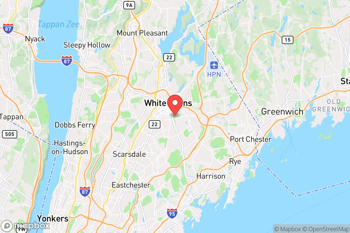
Strategic Assessment of White Plains, NY
High tactical risk. This location is likely close to major population centers, strategic targets, or sits in a high-disaster corridor. A retreat property and careful exit planning is required.
What does the Strategic Assessment tell us?
Our Strategic Assessment grades tactical survivability of an area. Major population centers, military targets, fallout zones, natural disasters, and border exposure all drive risk — lower exposure means a more defensible position in a crisis.
This is heavily inspired by Joel Skousen's Strategic Relocation book. Highly recommended you checkout the book ($)What does this tell us?
Our Strategic Assessment grades tactical survivability of an area. Major population centers, military targets, fallout zones, natural disasters, and border exposure all drive risk — lower exposure means a more defensible position in a crisis.
This is heavily inspired by Joel Skousen's Strategic Relocation book. Highly recommended you checkout the book ($)Strategic Pillars

Key Distances
Regional Safe Places
Below is our recommended "safe zones" in New York and the surrounding area based on our strategic heuristics. For most people, it's unrealistic to live in a “safe zone” full-time due to work, family or other personal reasons. They tend to be more rural. However, many of these areas are perfect for second homes and retreat properties that double as a vacation home or even a short-term rental.


Important Note: For informational purposes only. This does not mean nothing bad ever happens in the green zones. Please use common sense. This is based on public data and modeled with AI. We tried to take a conservative approach but mistakes happen. We update this regularly as new information becomes available.
Solar Generator Recommendations
Backup power matters more here than in safer locations. We've picked three solar generators across budgets and capacity tiers — start with the budget unit if you only need a few essentials, or step up if you want to run a fridge and HVAC for days at a time.

Jackery Portable Power Station Explorer 300
Budget OptionPower on the Go: Weighing only 11 lbs, it's convenient to set up and store with book-sized foldable solar panels

BLUETTI Portable Power Station AC180
Designed for both indoor and outdoor scenarios, AC180 is highly capable as it has a robost capacity and continuous output power.

EF ECOFLOW DELTA Pro Ultra Power Station
Upgraded PickEcoFlow DELTA Pro Ultra is a whole-home energy system designed to grow with your family. Integrated with the Smart Home Panel 2, it scales to meet your evolving energy needs — keeping your home powered, intelligent, and secure through every stage of life.
We earn a commission, at no additional cost to you.
Strategic Assessment Analysis
White Plains, New York, presents a complex strategic picture for the conservative prepper or survivalist. Its position as the county seat of Westchester County, roughly 25 miles north of Midtown Manhattan, offers a mix of economic resilience and significant vulnerability. While the city itself is a dense, high-value target with deep ties to the coastal establishment, its location provides a unique set of natural advantages and logistical choke points that a disciplined relocator can leverage. The key is understanding that White Plains is not a retreat; it is a forward operating base with a specific, high-risk, high-reward profile for those who value proximity to power centers but are prepared for the fallout of their collapse.
Geographic Position and Natural Advantages for a Prepared Relocator
White Plains sits on a series of hills and ridges, with the Bronx River and the Mamaroneck River carving through the landscape. This topography offers natural defensibility, as the higher elevations provide excellent observation points over the surrounding valleys and the major transit corridors leading into New York City. The city is a nexus for the Metro-North Railroad's Harlem Line, I-287, I-684, and the Hutchinson River Parkway, meaning you are at the center of a transportation web that can be both a lifeline and a liability. The natural advantage here is the Kensico Reservoir and the New Croton Reservoir, both within a 15-minute drive, providing a massive, protected freshwater source that is less likely to be immediately compromised than the city's own systems. The surrounding area, including the towns of North Castle and Armonk, has significant forest cover and rural pockets, offering potential bug-out locations or resupply points that are not immediately obvious to someone fleeing the city. The Palisades Interstate Park and the Ward Pound Ridge Reservation are within 30 minutes, providing substantial wilderness for caching supplies or establishing a secondary position.
Risks, Exposures, and Proximity to Fallout-Relevant Landmarks
The primary risk is proximity to New York City, a prime target for any large-scale attack, whether nuclear, biological, or conventional. White Plains is within the blast radius and fallout zone of a major nuclear detonation in Manhattan, depending on yield and wind patterns. The city is also directly in the path of any mass evacuation from the city, meaning the roads (I-287, the Cross Westchester Expressway) will become impassable within hours of a major event. Furthermore, White Plains is home to the Westchester County Airport (HPN), a major general aviation and corporate jet hub. In a crisis, this airport becomes a high-value target for looters, government seizure, or a secondary attack. The city also hosts the White Plains Hospital, a major medical center that will be overwhelmed in any mass casualty event, making it a dangerous place to be. The concentration of corporate headquarters (e.g., PepsiCo, IBM, Mastercard, Heineken USA) and financial services firms makes the downtown area a likely target for civil unrest, as it represents the economic elite of the region. The Indian Point Energy Center (though decommissioned) is only 20 miles south, and while it is no longer a reactor, the spent fuel pools remain a long-term contamination risk if the site is compromised.
Practical Resilience for a Relocator: Food, Water, Energy, and Defensibility
For a relocator, White Plains offers a mixed bag. Food security is a major weakness. The city is almost entirely dependent on just-in-time delivery from industrial food distributors. The local supermarkets (Stop & Shop, Whole Foods, Trader Joe's) will be stripped bare within hours of a crisis. You must have a minimum of 90 days of non-perishable food stored, and you should identify local farms and farmers' markets in the surrounding towns (e.g., the Bedford Farmers Market, Pound Ridge Farmers Market) for barter and fresh produce. Water security is better than most. The Kensico Reservoir is a massive, protected source, but you need a reliable filtration system (e.g., a Berkey or a Sawyer filter) and a plan to access it without being detected. The city's municipal water supply is vulnerable to contamination or shutdown. Energy independence is difficult in a dense suburb. Solar panels are possible, but many homes are shaded by mature trees. A whole-house propane generator with a buried 500-gallon tank is the most practical solution for a single-family home, but you must have a secure fuel supply. The grid is old and vulnerable to weather events (ice storms, hurricanes) and cyberattacks. Defensibility is the hardest challenge. White Plains is not a fortress. The best approach is to live on the periphery, in a neighborhood with limited access points (e.g., a cul-de-sac on a hill). A home with a basement for shelter, a clear field of fire, and a strong perimeter (fencing, reinforced doors, security cameras) is essential. You must also have a bug-out vehicle (a 4x4 truck or SUV) that is always fueled and packed with a go-bag, as the city is a trap if you cannot leave quickly. The local police department is well-funded and professional, but in a widespread collapse, they will be overwhelmed and focused on protecting the downtown core, not your suburban street.
The overall strategic picture for White Plains is that it is a high-risk, high-option location. It is not a safe haven for a long-term retreat. It is a place to be embedded in the system, gathering intelligence, building a network, and preparing for the moment when you must execute your plan. The advantages are real: access to water, defensible terrain, and a position that allows you to observe the collapse of the coastal elite from a front-row seat. The disadvantages are equally real: proximity to a primary target, dependence on fragile supply chains, and a population density that will turn into a mob. For the conservative prepper who wants to be close to the action, who has the resources to harden a home and the discipline to maintain a low profile, White Plains is a viable strategic outpost. For anyone seeking a quiet, low-risk retreat, it is a death trap. Know your mission, know your exit, and never forget that the city is a liability, not an asset.
* Values derived from national, state, county, city and local statistics and may differ in a specific area. Last updated: 2026-05-01T23:54:06.000Z
Narrative content on this page is AI-generated and may contain mistakes. Verify any details that matter before acting on them.
ReloMaps may earn a commission from affiliate links at no extra cost to you.