Photo: Phil Harvey via Unsplash
Strategic Assessment of Annetta, TX
Meaningful friction. Expect exposure to either population pressure, blast zones, or natural disaster risk. Consider buying a retreat property.
What does the Strategic Assessment tell us?
Our Strategic Assessment grades tactical survivability of an area. Major population centers, military targets, fallout zones, natural disasters, and border exposure all drive risk — lower exposure means a more defensible position in a crisis.
This is heavily inspired by Joel Skousen's Strategic Relocation book. Highly recommended you checkout the book ($)What does this tell us?
Our Strategic Assessment grades tactical survivability of an area. Major population centers, military targets, fallout zones, natural disasters, and border exposure all drive risk — lower exposure means a more defensible position in a crisis.
This is heavily inspired by Joel Skousen's Strategic Relocation book. Highly recommended you checkout the book ($)Strategic Pillars

Key Distances
Regional Safe Places
Below is our recommended "safe zones" in Texas and the surrounding area based on our strategic heuristics. For most people, it's unrealistic to live in a “safe zone” full-time due to work, family or other personal reasons. They tend to be more rural. However, many of these areas are perfect for second homes and retreat properties that double as a vacation home or even a short-term rental.


Important Note: For informational purposes only. This does not mean nothing bad ever happens in the green zones. Please use common sense. This is based on public data and modeled with AI. We tried to take a conservative approach but mistakes happen. We update this regularly as new information becomes available.
Solar Generator Recommendations
Backup power matters more here than in safer locations. We've picked three solar generators across budgets and capacity tiers — start with the budget unit if you only need a few essentials, or step up if you want to run a fridge and HVAC for days at a time.

Jackery Portable Power Station Explorer 300
Budget OptionPower on the Go: Weighing only 11 lbs, it's convenient to set up and store with book-sized foldable solar panels

BLUETTI Portable Power Station AC180
Designed for both indoor and outdoor scenarios, AC180 is highly capable as it has a robost capacity and continuous output power.

EF ECOFLOW DELTA Pro Ultra Power Station
Upgraded PickEcoFlow DELTA Pro Ultra is a whole-home energy system designed to grow with your family. Integrated with the Smart Home Panel 2, it scales to meet your evolving energy needs — keeping your home powered, intelligent, and secure through every stage of life.
We earn a commission, at no additional cost to you.
Strategic Assessment Analysis
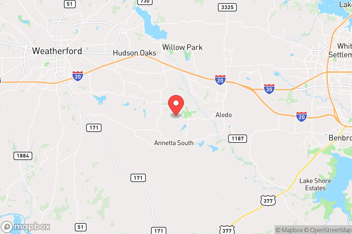
Annetta, Texas, offers a compelling strategic position for those prioritizing resilience and self-sufficiency, sitting just far enough from the Dallas-Fort Worth metroplex to avoid its immediate fallout risks while remaining within a practical distance for supply runs or medical access. This small town in Parker County benefits from a low population density, a conservative local culture that values preparedness, and a geography that is less prone to natural disasters than coastal or tornado-alley hotspots. For a relocator concerned with civic unrest, mass casualty events, or systemic collapse, Annetta provides a quiet base with defensible terrain and a community that largely shares a mindset of independence and mutual aid.
Geographic position and natural advantages for long-term security
Annetta sits on the western edge of the Dallas-Fort Worth metroplex, roughly 30 miles from downtown Fort Worth, placing it in a sweet spot for strategic relocation. The area is part of the Cross Timbers region, characterized by rolling hills, oak and juniper woodlands, and limestone bedrock—terrain that offers natural cover and limited line-of-sight for potential threats. The elevation is slightly higher than the surrounding plains, which aids in drainage and reduces flood risk compared to areas closer to the Trinity River. Parker County as a whole sees fewer tornadoes than the traditional "Tornado Alley" counties to the north and east, though severe weather is still a factor. The local water table is reliable, with several small creeks and the Brazos River watershed nearby, making well water a viable option for those who drill deep enough. The climate is semi-arid, with hot summers and mild winters, which reduces the strain on off-grid energy systems and allows for year-round gardening with proper planning.
Risks, exposures, and proximity to fallout-relevant landmarks
The primary strategic risk for Annetta is its proximity to the Dallas-Fort Worth metroplex, a major population center that would be a likely target for civil unrest, infrastructure collapse, or a mass casualty event. In a scenario involving a coordinated attack or widespread breakdown, the 30-mile buffer provides a critical escape corridor, but it is not a guarantee of safety. Interstate 20 and U.S. Highway 180 are the main arteries connecting Annetta to Fort Worth, and both could become choke points during an evacuation. The area is also within 50 miles of the Pantex nuclear weapons plant near Amarillo, though prevailing winds generally carry fallout eastward, reducing direct risk. More immediate concerns include the proximity to natural gas pipelines and the Barnett Shale drilling fields, which could pose explosion or contamination hazards in a disaster scenario. The local power grid is tied to the ERCOT system, which has shown vulnerability during winter storms, as seen in 2021. For a prepper, these risks are manageable with proper planning—stockpiling supplies, securing alternative energy, and having a bug-out route that avoids major highways.
Practical resilience for a relocator: food, water, energy, and defensibility
Annetta’s rural character makes it a strong candidate for self-sufficient living. Most lots are one to five acres, with some larger parcels available, allowing for private gardens, livestock, and rainwater catchment systems. The soil is sandy loam in many areas, suitable for vegetables and fruit trees with amendment, and the growing season runs from March to November. Water access is the biggest variable: municipal water is available in the town proper, but many properties rely on private wells, which typically yield 10–20 gallons per minute at depths of 200–400 feet. A backup generator or solar array is essential, as the local grid is prone to outages during ice storms or summer demand spikes. Solar potential is good, with an average of 230 sunny days per year, and wind energy is viable on larger plots. Defensibility is aided by the wooded terrain and limited road access—Annetta has only a few main roads, and most neighborhoods are dead-end or cul-de-sac layouts, making it easier to monitor approach points. The local sheriff’s office in Weatherford is responsive, but response times can exceed 20 minutes in remote parts of the county, so a well-stocked first aid kit, firearms training, and a neighborhood watch network are practical investments.
For a relocator with a survivalist mindset, Annetta presents a balanced strategic picture: it is close enough to urban resources to be practical, yet far enough to offer a buffer against the worst-case scenarios of civic unrest or infrastructure collapse. The conservative culture and low crime rate reduce the likelihood of internal threats, while the geography and climate support long-term off-grid living. The main trade-off is the proximity to a major metroplex, which requires a disciplined approach to security and supply management. For those willing to invest in well water, solar power, and a defensible property, Annetta offers a quiet, resilient base that can weather most disruptions short of a direct nuclear strike on Fort Worth. It is not a remote bunker, but it is a solid, livable option for those who want to be prepared without disappearing into the wilderness.
* Values derived from national, state, county, city and local statistics and may differ in a specific area. Last updated: 2026-04-11T19:02:20.000Z
Narrative content on this page is AI-generated and may contain mistakes. Verify any details that matter before acting on them.
ReloMaps may earn a commission from affiliate links at no extra cost to you.