
Photo: Wikipedia
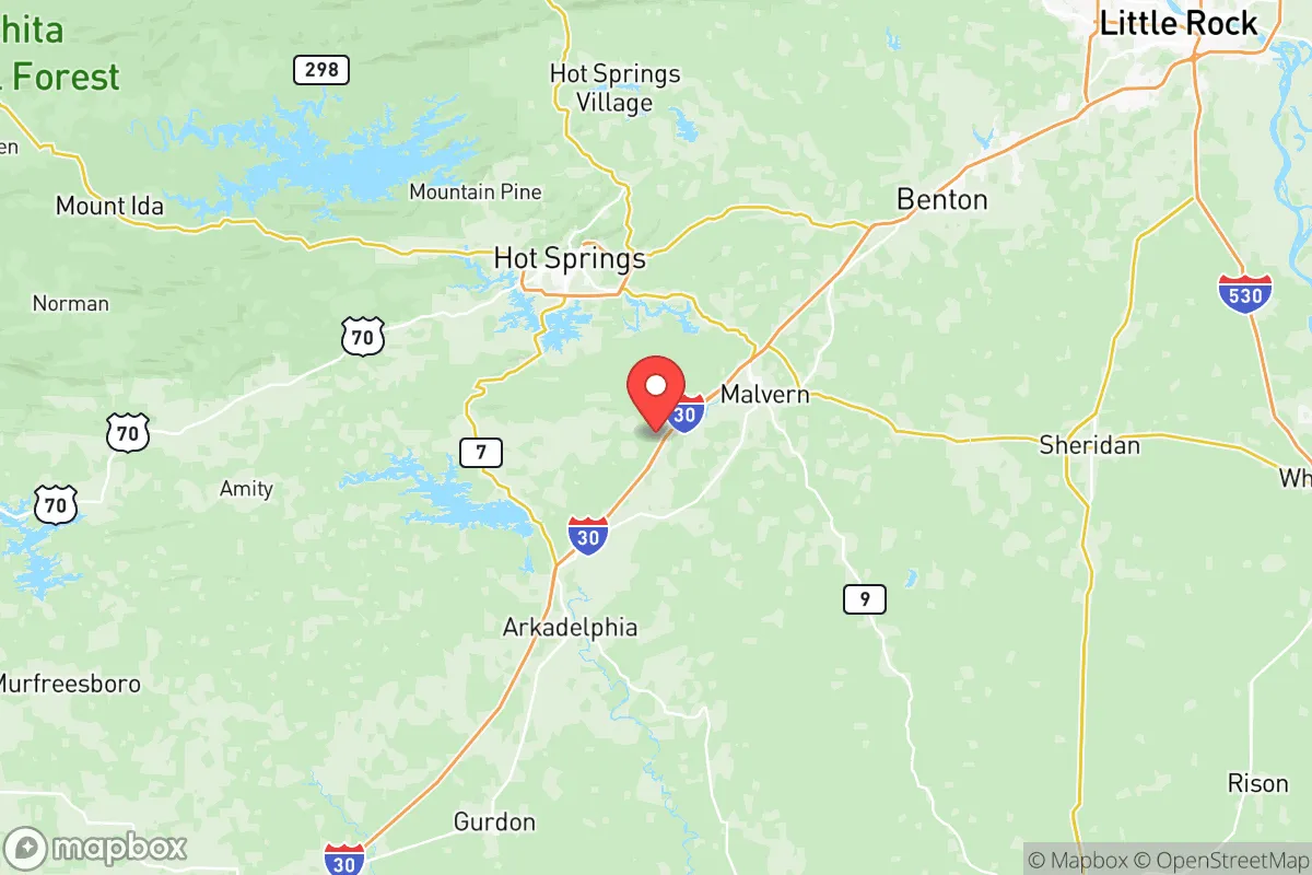
Strategic Assessment of Hot Spring County
Strong survivability profile. Good buffer from population centers, with manageable environmental and tactical risks.
What does the Strategic Assessment tell us?
Our Strategic Assessment grades tactical survivability of an area. Major population centers, military targets, fallout zones, natural disasters, and border exposure all drive risk — lower exposure means a more defensible position in a crisis.
This is heavily inspired by Joel Skousen's Strategic Relocation book. Highly recommended you checkout the book ($)What does this tell us?
Our Strategic Assessment grades tactical survivability of an area. Major population centers, military targets, fallout zones, natural disasters, and border exposure all drive risk — lower exposure means a more defensible position in a crisis.
This is heavily inspired by Joel Skousen's Strategic Relocation book. Highly recommended you checkout the book ($)Strategic Pillars

Key Distances
Strategic Assessment Analysis
Hot Spring County, Arkansas, sits in a strategic sweet spot that resilience-minded relocators should take seriously—far enough from primary targets to offer genuine separation, close enough to supply corridors to matter. The county's position southwest of Little Rock, anchored by the county seat of Malvern and surrounded by the Ouachita National Forest, gives it a blend of rural depth and logistical access that most pure remote areas lack. For those who see the national trajectory pointing toward increased instability, this part of central Arkansas offers a survivable baseline without requiring a complete off-grid disconnect.
Geographic positioning and what the terrain gives you
The biggest strategic asset Hot Spring County offers is terrain complexity. The Ouachita Mountains run through the county's western half, creating a landscape of ridges, valleys, and dense hardwood forests that naturally slow movement and provide cover. Unlike the flat agricultural expanses of eastern Arkansas, this topography creates defensible pockets—places like the area around Magnet Cove, where narrow hollows and steep slopes limit approach routes. The county sits roughly 45 miles southwest of Little Rock, which is close enough to tap into medical and supply infrastructure during stable periods but far enough that a collapse event in the city wouldn't immediately overrun the area. Interstate 30 runs through the southern edge of the county, giving direct highway access to both Little Rock and Texarkana. That's a double-edged sword: useful for evacuation or supply runs, but also a potential funnel for urban refugees during a crisis. The more remote northern and western parts of the county, around the Lake Ouachita shoreline and the Forest Service lands near Social Hill, offer better separation from that corridor.
Risks exposures and what's too close for comfort
No county is an island, and Hot Spring County has exposure points that need honest reckoning. The most significant risk is proximity to Hot Springs itself—the city and its surrounding tourist economy sit just across the county line in Garland County, about 10 miles west of Malvern. Hot Springs draws millions of visitors annually, and during a pandemic, economic collapse, or civil unrest scenario, that population could become a liability. Tourist populations have no local supply chains, no community ties, and no reason to stay put—they'll move, and they'll move along the same highways locals rely on. The Garland County line is porous, and the corridor between Hot Springs and Malvern along US-70 is developed enough that there's no natural buffer. Lake Ouachita, while a tremendous water resource, also draws recreational traffic from a multi-state area, meaning seasonal population surges that could complicate security. On the industrial side, there are no major refineries, chemical plants, or military installations inside Hot Spring County, which is a positive—no primary-target risk. But the Arkansas Nuclear One plant in Russellville is roughly 90 miles north, within plausible fallout range depending on wind patterns and yield. Little Rock Air Force Base in Jacksonville is about 60 miles northeast—a secondary target that could generate military traffic and potentially displaced personnel. The county's position along the I-30 corridor also means it sits on a likely movement route between Dallas-Fort Worth and the mid-South, which could see heavy transient traffic during any large-scale disruption.
Practical resilience for a relocator—food water energy and defensibility
For someone looking to build a sustainable setup, Hot Spring County offers workable fundamentals. Surface water is abundant: the Ouachita River runs through the county, Lake Ouachita provides a massive reservoir to the west, and smaller creeks like the Caddo and Gulpha drain through the area. Groundwater quality in the Ouachita Mountain region is generally good, with many rural properties on private wells producing reliable yield from the Arkansas Novaculite formation. Growing conditions are viable but not premium—the growing season runs about 210 days, and the clay-loam soils in the valleys can produce decent garden yields with amendment, but the hillsides are thin and rocky. Livestock is common in the area, and existing agricultural infrastructure means feed, fencing, and veterinary supplies are available locally in Malvern and Rockport. Energy resilience is moderate: the rural electric cooperatives serve most of the county, but outages during ice storms and summer storms are frequent enough that residents take backup power seriously. Wood heating is practical given the forest cover, and solar potential is adequate—the area averages about 210 sunny days per year, not great compared to the Southwest but workable with a properly sized system. Defensibility varies by location: the open farmland around Donaldson and Friendship offers long sightlines but limited cover, while the hollows near Magnet Cove and the ridges around Lake Ouachita provide natural chokepoints and observation positions. The county's low population density—roughly 33 people per square mile—means neighbors are few and far between, which reduces the chance of friction during a resource-scarce period but also means mutual aid requires deliberate relationship building.
The overall strategic picture for Hot Spring County is that of a viable fallback zone with manageable tradeoffs. It lacks the deep isolation of far-northern Arkansas or the Ozarks, but it compensates with better road access to supplies, a more temperate winter climate, and water resources that don't freeze solid for months. The proximity to Little Rock and Hot Springs is a genuine risk—any relocator needs a plan for managing that exposure, whether through property siting, community screening, or a staged evacuation route deeper into the Ouachitas. For the prepper or survivalist who wants a base within striking distance of urban infrastructure during stability but removed enough to ride out a crisis, Hot Spring County earns a legitimate look. It's not a fortress, but it's a solid position on the map—and in an increasingly uncertain landscape, that counts for more than most people realize.
* Values derived from national, state, county, city and local statistics and may differ in a specific area. Last updated: 2026-05-21T06:00:56.000Z
Narrative content on this page is AI-generated and may contain mistakes. Verify any details that matter before acting on them.
ReloMaps may earn a commission from affiliate links at no extra cost to you.