Photo: Wikipedia
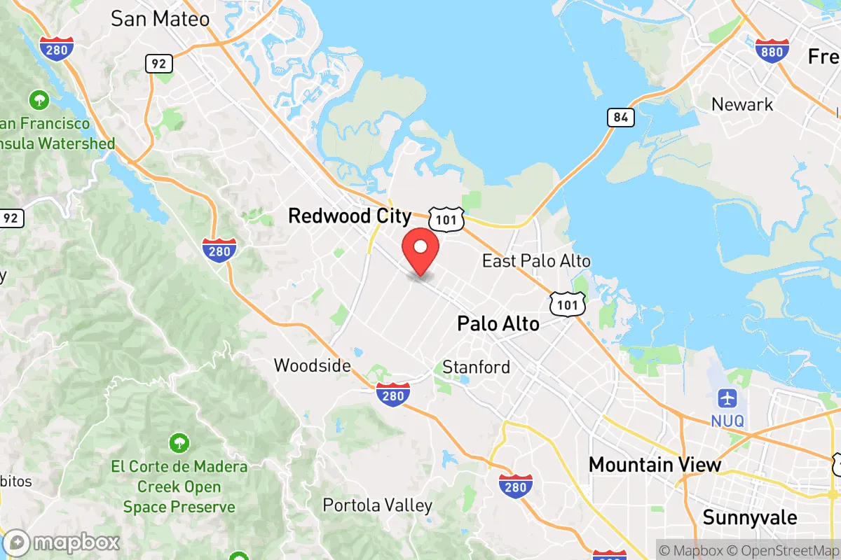
Strategic Assessment of Atherton, CA
Multiple tactical vulnerabilities. Population density, target proximity, or disaster risk are likely compounding. A retreat property and exit planning is required.
What does the Strategic Assessment tell us?
Our Strategic Assessment grades tactical survivability of an area. Major population centers, military targets, fallout zones, natural disasters, and border exposure all drive risk — lower exposure means a more defensible position in a crisis.
This is heavily inspired by Joel Skousen's Strategic Relocation book. Highly recommended you checkout the book ($)What does this tell us?
Our Strategic Assessment grades tactical survivability of an area. Major population centers, military targets, fallout zones, natural disasters, and border exposure all drive risk — lower exposure means a more defensible position in a crisis.
This is heavily inspired by Joel Skousen's Strategic Relocation book. Highly recommended you checkout the book ($)Strategic Pillars

Key Distances
Regional Safe Places
Below is our recommended "safe zones" in California and the surrounding area based on our strategic heuristics. For most people, it's unrealistic to live in a “safe zone” full-time due to work, family or other personal reasons. They tend to be more rural. However, many of these areas are perfect for second homes and retreat properties that double as a vacation home or even a short-term rental.


Important Note: For informational purposes only. This does not mean nothing bad ever happens in the green zones. Please use common sense. This is based on public data and modeled with AI. We tried to take a conservative approach but mistakes happen. We update this regularly as new information becomes available.
Solar Generator Recommendations
Backup power matters more here than in safer locations. We've picked three solar generators across budgets and capacity tiers — start with the budget unit if you only need a few essentials, or step up if you want to run a fridge and HVAC for days at a time.

Jackery Portable Power Station Explorer 300
Budget OptionPower on the Go: Weighing only 11 lbs, it's convenient to set up and store with book-sized foldable solar panels

BLUETTI Portable Power Station AC180
Designed for both indoor and outdoor scenarios, AC180 is highly capable as it has a robost capacity and continuous output power.

EF ECOFLOW DELTA Pro Ultra Power Station
Upgraded PickEcoFlow DELTA Pro Ultra is a whole-home energy system designed to grow with your family. Integrated with the Smart Home Panel 2, it scales to meet your evolving energy needs — keeping your home powered, intelligent, and secure through every stage of life.
We earn a commission, at no additional cost to you.
Strategic Assessment Analysis
Atherton, California, presents a complex strategic picture for the conservative prepper or survivalist. Its primary value lies in its extreme wealth, low crime, and physical isolation from the chaos of the Bay Area, but its location within the heart of one of the most politically volatile and disaster-prone regions in the country creates a paradox that demands careful analysis. The town’s resilience is not inherent to its geography, but rather a product of its economic insulation and the high level of private security that money can buy. For a relocator seeking true strategic depth, Atherton offers a fortified outpost, but one that sits directly in the shadow of multiple catastrophic failure points.
Geographic position and natural advantages for a secure retreat
Atherton’s primary natural advantage is its position on the San Francisco Peninsula, roughly halfway between San Francisco and San Jose. This location provides a degree of physical separation from the immediate urban core, but it is not remote. The town is nestled among the rolling hills of the Peninsula, with the Santa Cruz Mountains to the west and the San Francisco Bay to the east. This topography offers some natural chokepoints for road access, particularly along the few major arteries like El Camino Real and Interstate 280. The climate is Mediterranean, with mild, wet winters and dry summers, which reduces the risk of extreme cold or heat-related survival challenges. The area’s natural beauty and low population density relative to surrounding cities are a plus, but the real advantage is the town’s extremely low crime rate—often cited as one of the safest in California—which means that in a societal breakdown scenario, the existing security infrastructure (private patrols, gated estates, and a well-funded police force) would be a significant asset. However, this is a double-edged sword: the very wealth that makes it safe also makes it a target.
Risks, exposures, and proximity to fallout-relevant landmarks
This is where the strategic picture turns sharply negative. Atherton sits within a 30-mile radius of multiple high-value, high-risk targets. To the north is San Francisco, a major port, financial hub, and the epicenter of the state’s progressive political machine. To the south is San Jose, the heart of Silicon Valley, home to tech giants like Apple, Google, and Meta, as well as critical infrastructure like the San Jose International Airport. To the west, across the mountains, lies the Pacific Coast and the Port of Oakland, a major shipping and military logistics point. In a scenario involving civil unrest, mass casualty events, or a coordinated attack, these locations would be primary targets. The fallout—both literal and figurative—would be severe. The proximity to the San Andreas Fault, which runs just a few miles to the west, is a constant geological threat that could collapse infrastructure, isolate the peninsula, and trigger secondary disasters like fires and chemical spills. Furthermore, the town’s reliance on the Bay Area’s electrical grid, water supply (primarily from the Hetch Hetchy system), and food distribution networks means that any disruption to these systems would hit Atherton just as hard as the surrounding cities, despite its wealth. The concentration of high-net-worth individuals also makes it a likely target for looting or hostage-taking in a breakdown scenario.
Practical resilience for a relocator: food, water, energy, and defensibility
For a relocator with a prepper mindset, Atherton’s practical resilience is a mixed bag. On the positive side, the town’s large lots (many estates are 1-5 acres) provide space for private wells, solar panels, and even small-scale food production. The wealthy residents often have backup generators, private water storage, and extensive security systems. However, the reality is that most of the town is not set up for long-term self-sufficiency. The soil is not ideal for large-scale agriculture, and the climate, while mild, is not conducive to year-round food production without significant inputs. Water is a critical vulnerability: the region is prone to drought, and the municipal supply is dependent on a complex system of reservoirs and aqueducts that could be easily disrupted. Energy is less of a concern for those who can afford to install off-grid solar and battery systems, but the town’s grid is still connected to the broader, fragile California grid. Defensibility is the strongest card Atherton holds. The town is essentially a gated community writ large, with limited entry points, a well-funded police force, and a culture of privacy. In a crisis, the wealthy could quickly organize private security, and the physical layout of the estates—with high walls, gates, and long driveways—makes it difficult for outsiders to penetrate. But this is a defensive posture, not a sustainable one. Without a plan for water, food, and medical supplies, the town becomes a fortified prison rather than a self-sufficient retreat.
The overall strategic picture for Atherton is one of high risk and high reward, but only for a very specific type of relocator. If you have the financial resources to buy into this enclave, and you are willing to invest heavily in off-grid infrastructure, private security, and a robust supply chain, it can serve as a temporary safe haven during a short-term crisis. However, for a long-term survival scenario—one involving a complete societal breakdown, a pandemic, or a major natural disaster—Atherton’s location in the heart of the Bay Area’s target-rich environment makes it a liability. The town’s wealth will attract attention, its dependence on fragile external systems will become a critical weakness, and its proximity to multiple catastrophic failure points means that the fallout will be immediate and severe. For the conservative prepper seeking true strategic depth, the remote mountain towns of the Sierra Nevada or the high desert of the interior West offer far better long-term prospects. Atherton is a place to ride out a storm, not to weather a collapse. It is a fortified outpost in enemy territory, not a sovereign redoubt. If you are looking for a place to wait out the chaos while maintaining a high standard of living, it might work. But if you are planning for the worst, look elsewhere.
* Values derived from national, state, county, city and local statistics and may differ in a specific area. Last updated: 2026-04-16T03:08:55.000Z
Narrative content on this page is AI-generated and may contain mistakes. Verify any details that matter before acting on them.
ReloMaps may earn a commission from affiliate links at no extra cost to you.