

Photo: Wikipedia
Strategic Assessment of Bridgeport, CT
High tactical risk. This location is likely close to major population centers, strategic targets, or sits in a high-disaster corridor. A retreat property and careful exit planning is required.
What does the Strategic Assessment tell us?
Our Strategic Assessment grades tactical survivability of an area. Major population centers, military targets, fallout zones, natural disasters, and border exposure all drive risk — lower exposure means a more defensible position in a crisis.
This is heavily inspired by Joel Skousen's Strategic Relocation book. Highly recommended you checkout the book ($)What does this tell us?
Our Strategic Assessment grades tactical survivability of an area. Major population centers, military targets, fallout zones, natural disasters, and border exposure all drive risk — lower exposure means a more defensible position in a crisis.
This is heavily inspired by Joel Skousen's Strategic Relocation book. Highly recommended you checkout the book ($)Strategic Pillars

Key Distances
Regional Safe Places
Below is our recommended "safe zones" in Connecticut and the surrounding area based on our strategic heuristics. For most people, it's unrealistic to live in a “safe zone” full-time due to work, family or other personal reasons. They tend to be more rural. However, many of these areas are perfect for second homes and retreat properties that double as a vacation home or even a short-term rental.


Important Note: For informational purposes only. This does not mean nothing bad ever happens in the green zones. Please use common sense. This is based on public data and modeled with AI. We tried to take a conservative approach but mistakes happen. We update this regularly as new information becomes available.
Solar Generator Recommendations
Backup power matters more here than in safer locations. We've picked three solar generators across budgets and capacity tiers — start with the budget unit if you only need a few essentials, or step up if you want to run a fridge and HVAC for days at a time.

Jackery Portable Power Station Explorer 300
Budget OptionPower on the Go: Weighing only 11 lbs, it's convenient to set up and store with book-sized foldable solar panels

BLUETTI Portable Power Station AC180
Designed for both indoor and outdoor scenarios, AC180 is highly capable as it has a robost capacity and continuous output power.

EF ECOFLOW DELTA Pro Ultra Power Station
Upgraded PickEcoFlow DELTA Pro Ultra is a whole-home energy system designed to grow with your family. Integrated with the Smart Home Panel 2, it scales to meet your evolving energy needs — keeping your home powered, intelligent, and secure through every stage of life.
We earn a commission, at no additional cost to you.
Strategic Assessment Analysis
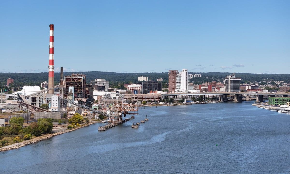
Bridgeport, Connecticut, presents a complex strategic picture for the conservative prepper. While its location on Long Island Sound offers maritime access and a temperate climate, its position as Connecticut’s largest city—with a population of roughly 148,000—places it directly in the crosshairs of the Northeast Corridor’s vulnerabilities. The city’s resilience is a double-edged sword: its industrial history and port infrastructure provide logistical advantages, but its dense urban core and proximity to New York City (just 55 miles away) make it a high-risk zone for fallout from civil unrest, mass casualty events, and cascading infrastructure failures. For a relocator prioritizing self-sufficiency and security, Bridgeport demands a hard-eyed assessment of its geographic strengths and its exposure to the region’s systemic fragilities.
Geographic position and natural advantages for a survivalist
Bridgeport sits on the western edge of the Connecticut coast, with direct access to Long Island Sound and the Atlantic via the Bridgeport Harbor. This maritime position offers a significant strategic asset: a potential waterborne escape route or resupply corridor if land routes become compromised. The city is also flanked by the Housatonic River to the west and the Pequonnock River to the east, providing freshwater sources and natural barriers. The surrounding region—Fairfield County—includes rural pockets like Trumbull and Monroe, which offer wooded terrain and lower population density within a 15- to 20-minute drive. The climate is moderate, with average winter lows around 20°F and summer highs near 80°F, reducing the survival stress of extreme temperatures. However, the area’s natural advantages are tempered by its location in a densely populated corridor. The I-95 and I-91 highways, which run through Bridgeport, are choke points that would likely become impassable during a mass evacuation event. The city’s proximity to the New York metropolitan area—home to over 20 million people—means that any major disaster in the city would send a wave of refugees northward, overwhelming local resources. For a prepper, the coastal access is a plus, but the land-based escape routes are a liability.
Risks, exposures, and proximity to fallout-relevant landmarks
Bridgeport’s strategic liabilities are substantial. The city is within a 60-mile radius of multiple high-value targets: New York City’s financial district, the Indian Point nuclear power plant (now decommissioned but still containing spent fuel), and the Millstone Nuclear Power Station in Waterford, Connecticut (about 40 miles east). A nuclear incident at Millstone or a terrorist strike on New York could produce fallout that reaches Bridgeport within hours, depending on wind patterns. The city’s own industrial infrastructure—including the Bridgeport Harbor Station (a former coal plant) and numerous chemical storage facilities along the harbor—poses a secondary risk of toxic releases during a disaster. Additionally, Bridgeport’s location on the Atlantic coast makes it vulnerable to hurricanes and nor’easters, which can knock out power for days or weeks, as seen during Superstorm Sandy in 2012. The city’s population density—over 9,000 people per square mile—means that civil unrest, such as the 2020 protests that saw looting and arson in downtown Bridgeport, could escalate quickly. For a conservative relocator, the proximity to New York City is a double threat: it’s both a source of potential refugees and a target for attacks that could destabilize the entire region. The city’s reliance on the regional power grid and water supply (from the Bridgeport Hydraulic Company) also makes it vulnerable to cascading failures.
Practical resilience for a relocator: food, water, energy, and defensibility
For a prepper looking to establish a foothold in Bridgeport, the practical challenges are steep. The city’s water supply comes from a network of reservoirs in the surrounding towns, but the treatment and distribution system is centralized and vulnerable to contamination or sabotage. A well-maintained rainwater catchment system or a deep well on a private property would be essential, but such setups are rare in the urban core. Food security is similarly limited: Bridgeport has a few community gardens and farmers’ markets, but the city is a food desert for many residents, relying on truck deliveries from distant distribution centers. During a prolonged disruption, local grocery stores would empty within days. Energy resilience is a mixed bag: the city has a municipal electric utility (United Illuminating), but the grid is aging and prone to outages. Solar panels with battery storage are feasible on single-family homes, but the city’s zoning and building codes can be restrictive. Defensibility is the weakest point. Bridgeport’s urban layout—with dense row houses, narrow streets, and a high crime rate (the city’s violent crime rate is roughly 3 times the national average)—makes it difficult to secure a property. A suburban or rural property in a town like Easton or Shelton, within a 20-minute drive, would offer better defensibility, with larger lots, wooded cover, and lower population density. For a relocator, the practical advice is clear: avoid the urban core and look for a property with a private well, septic system, and space for a garden, ideally on a dead-end road with limited access points.
The overall strategic picture for Bridgeport is one of calculated risk. The city’s coastal location and industrial infrastructure offer some logistical advantages, but its density, proximity to New York City, and exposure to nuclear and industrial hazards make it a poor choice for a primary survival retreat. For a conservative prepper, the area’s best use is as a secondary location—a place to maintain a boat or a small cache of supplies for a maritime escape, or as a temporary staging point before moving inland to more defensible terrain in Litchfield County or the Berkshires. The city’s real value lies in its access to the Sound and its position as a transportation hub, but those same features make it a target. If you’re serious about long-term resilience, Bridgeport is a place to pass through, not to settle down. The smart move is to use it for what it offers—coastal access and regional connectivity—while basing your primary operations in a lower-risk, more defensible location within a 30- to 60-minute drive. That’s the honest assessment for anyone looking to weather the coming storms.
* Values derived from national, state, county, city and local statistics and may differ in a specific area. Last updated: 2026-04-24T12:22:16.000Z
Narrative content on this page is AI-generated and may contain mistakes. Verify any details that matter before acting on them.
ReloMaps may earn a commission from affiliate links at no extra cost to you.