Photo: Wikipedia
Strategic Assessment of Burnsville, MN
Multiple tactical vulnerabilities. Population density, target proximity, or disaster risk are likely compounding. A retreat property and exit planning is required.
What does the Strategic Assessment tell us?
Our Strategic Assessment grades tactical survivability of an area. Major population centers, military targets, fallout zones, natural disasters, and border exposure all drive risk — lower exposure means a more defensible position in a crisis.
This is heavily inspired by Joel Skousen's Strategic Relocation book. Highly recommended you checkout the book ($)What does this tell us?
Our Strategic Assessment grades tactical survivability of an area. Major population centers, military targets, fallout zones, natural disasters, and border exposure all drive risk — lower exposure means a more defensible position in a crisis.
This is heavily inspired by Joel Skousen's Strategic Relocation book. Highly recommended you checkout the book ($)Strategic Pillars

Key Distances
Regional Safe Places
Below is our recommended "safe zones" in Minnesota and the surrounding area based on our strategic heuristics. For most people, it's unrealistic to live in a “safe zone” full-time due to work, family or other personal reasons. They tend to be more rural. However, many of these areas are perfect for second homes and retreat properties that double as a vacation home or even a short-term rental.


Important Note: For informational purposes only. This does not mean nothing bad ever happens in the green zones. Please use common sense. This is based on public data and modeled with AI. We tried to take a conservative approach but mistakes happen. We update this regularly as new information becomes available.
Solar Generator Recommendations
Backup power matters more here than in safer locations. We've picked three solar generators across budgets and capacity tiers — start with the budget unit if you only need a few essentials, or step up if you want to run a fridge and HVAC for days at a time.

Jackery Portable Power Station Explorer 300
Budget OptionPower on the Go: Weighing only 11 lbs, it's convenient to set up and store with book-sized foldable solar panels

BLUETTI Portable Power Station AC180
Designed for both indoor and outdoor scenarios, AC180 is highly capable as it has a robost capacity and continuous output power.

EF ECOFLOW DELTA Pro Ultra Power Station
Upgraded PickEcoFlow DELTA Pro Ultra is a whole-home energy system designed to grow with your family. Integrated with the Smart Home Panel 2, it scales to meet your evolving energy needs — keeping your home powered, intelligent, and secure through every stage of life.
We earn a commission, at no additional cost to you.
Strategic Assessment Analysis
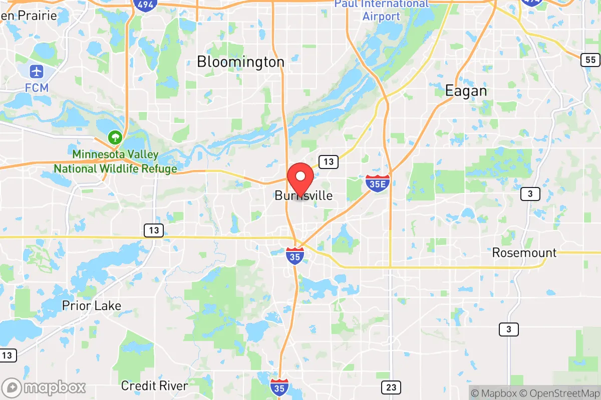
Burnsville, Minnesota, sits in a precarious strategic position that demands a hard-eyed assessment. While its location along the Minnesota River Valley offers some natural defensive terrain and water access, its proximity to the Twin Cities metropolitan area introduces significant vulnerabilities for anyone prioritizing long-term resilience. For the conservative prepper or survivalist, Burnsville presents a mixed bag: it has the bones of a defensible position but is dangerously close to the kind of population and infrastructure centers that become liabilities during civic unrest, mass casualty events, or cascading disasters. This analysis strips away the marketing gloss and looks at what Burnsville actually offers for those serious about strategic relocation.
Geographic position and natural advantages for long-term survival
Burnsville’s geography is its strongest card, but it’s a card that must be played carefully. The city sits on the bluffs overlooking the Minnesota River Valley, which provides natural elevation and chokepoints that could be leveraged for perimeter defense. The river itself is a reliable water source, though it requires treatment, and the valley’s floodplains offer fertile ground for subsistence farming if you can secure land outside the 100-year flood zone. The area is part of the larger Mississippi River watershed, meaning water access is not a question—it’s a given. The surrounding terrain is a mix of hardwood forest, agricultural fields, and suburban development, which gives you options for cover, foraging, and small-scale agriculture. However, the natural advantages are undercut by the sheer density of the metro area. Burnsville’s population of roughly 62,000 is packed into about 27 square miles, which means you’re never more than a few blocks from a neighbor. For a survivalist, that density is a double-edged sword: it provides a pool of potential community resources but also a concentration of potential threats during a breakdown of order. The key is to identify the less-developed pockets—the river bottoms, the wooded ravines, the agricultural edges—that offer a buffer from the suburban sprawl.
Risks, exposures, and proximity to fallout-relevant landmarks
This is where Burnsville’s strategic picture gets ugly. The city lies just 15 miles south of downtown Minneapolis and 10 miles from St. Paul, placing it well within the blast and fallout radius of any major attack on the Twin Cities. The Minneapolis–St. Paul International Airport (MSP) is a mere 8 miles north—a prime target for any adversary looking to cripple transportation and logistics. The nearby Mall of America in Bloomington is another high-profile symbolic target that would draw chaos and secondary effects. Beyond terrorism, consider the risks of civil unrest: Burnsville is connected to the metro via Interstate 35W and State Highway 13, major arteries that could become clogged with refugees or blocked by checkpoints during a crisis. The city’s own infrastructure—power substations, water treatment plants, and natural gas lines—is tied into the regional grid, meaning a cascading failure in the metro would ripple directly into Burnsville. There’s also the proximity to the Prairie Island Indian Community’s nuclear generating plant, about 30 miles southeast. While that’s outside the immediate danger zone for a meltdown, prevailing winds could carry fallout across the river valley. For the prepper, the calculus is simple: Burnsville is too close to too many high-value targets and chokepoints to be considered a safe haven. It’s a staging area at best, not a final redoubt.
Practical resilience for a relocator: food, water, energy, and defensibility
Let’s get practical about what a relocator can actually do here. Water: The Minnesota River is your primary source, but it’s heavily polluted with agricultural runoff and industrial contaminants. You’ll need a robust filtration system—think Berkey or a sand filter with UV treatment—and a plan to store at least a 30-day supply. The city’s municipal water comes from the Mississippi River via the Minneapolis system, which is vulnerable to both contamination and service interruption. Food: Burnsville has a handful of grocery stores and big-box retailers, but those will empty within 48 hours of a crisis. Local agriculture is limited; you’ll need to establish relationships with farmers in the surrounding Dakota and Scott counties, or better yet, secure land for your own garden. The growing season is short (about 150 days), so focus on cold-hardy crops and consider a greenhouse. Energy: The grid is unreliable in a crisis, and Burnsville’s suburban layout makes solar a challenge due to tree cover and HOA restrictions. A backup generator with a buried propane tank is your best bet, but fuel will be a vulnerability. Wood heating is viable if you have access to the river valley’s timber, but you’ll need a chainsaw and a plan to haul it. Defensibility: This is the weak point. Burnsville is a typical suburb—grid streets, cul-de-sacs, and open yards. There are no natural defensive positions like hilltops or dense forests to anchor a perimeter. The best you can do is harden a single-family home with reinforced doors, window film, and a clear line of sight to the street. Community defense is possible if you coordinate with neighbors, but that requires trust and shared values—something that’s increasingly scarce. For a single individual or a family, the defensibility is poor compared to a rural property in, say, northern Minnesota or the Driftless Area of Wisconsin.
The overall strategic picture for Burnsville is one of calculated risk. It offers genuine advantages in water access and terrain diversity, but those are outweighed by its proximity to the Twin Cities’ vulnerabilities. For the conservative prepper who values community and wants to be close to metro resources while maintaining a bug-out option, Burnsville could work as a base—but only if you have a secondary location 50+ miles out, preferably in a rural county with low population density and strong Second Amendment culture. If you’re looking for a place to hunker down and ride out the storm, keep driving south or west. Burnsville is a good place to live in peacetime, but in a crisis, it’s a trap waiting to spring.
* Values derived from national, state, county, city and local statistics and may differ in a specific area. Last updated: 2026-05-04T11:23:12.000Z
Narrative content on this page is AI-generated and may contain mistakes. Verify any details that matter before acting on them.
ReloMaps may earn a commission from affiliate links at no extra cost to you.