
Photo: Wikipedia
Strategic Assessment of Chester, PA
Multiple tactical vulnerabilities. Population density, target proximity, or disaster risk are likely compounding. A retreat property and exit planning is required.
What does the Strategic Assessment tell us?
Our Strategic Assessment grades tactical survivability of an area. Major population centers, military targets, fallout zones, natural disasters, and border exposure all drive risk — lower exposure means a more defensible position in a crisis.
This is heavily inspired by Joel Skousen's Strategic Relocation book. Highly recommended you checkout the book ($)What does this tell us?
Our Strategic Assessment grades tactical survivability of an area. Major population centers, military targets, fallout zones, natural disasters, and border exposure all drive risk — lower exposure means a more defensible position in a crisis.
This is heavily inspired by Joel Skousen's Strategic Relocation book. Highly recommended you checkout the book ($)Strategic Pillars

Key Distances
Regional Safe Places
Below is our recommended "safe zones" in Pennsylvania and the surrounding area based on our strategic heuristics. For most people, it's unrealistic to live in a “safe zone” full-time due to work, family or other personal reasons. They tend to be more rural. However, many of these areas are perfect for second homes and retreat properties that double as a vacation home or even a short-term rental.


Important Note: For informational purposes only. This does not mean nothing bad ever happens in the green zones. Please use common sense. This is based on public data and modeled with AI. We tried to take a conservative approach but mistakes happen. We update this regularly as new information becomes available.
Solar Generator Recommendations
Backup power matters more here than in safer locations. We've picked three solar generators across budgets and capacity tiers — start with the budget unit if you only need a few essentials, or step up if you want to run a fridge and HVAC for days at a time.

Jackery Portable Power Station Explorer 300
Budget OptionPower on the Go: Weighing only 11 lbs, it's convenient to set up and store with book-sized foldable solar panels

BLUETTI Portable Power Station AC180
Designed for both indoor and outdoor scenarios, AC180 is highly capable as it has a robost capacity and continuous output power.

EF ECOFLOW DELTA Pro Ultra Power Station
Upgraded PickEcoFlow DELTA Pro Ultra is a whole-home energy system designed to grow with your family. Integrated with the Smart Home Panel 2, it scales to meet your evolving energy needs — keeping your home powered, intelligent, and secure through every stage of life.
We earn a commission, at no additional cost to you.
Strategic Assessment Analysis
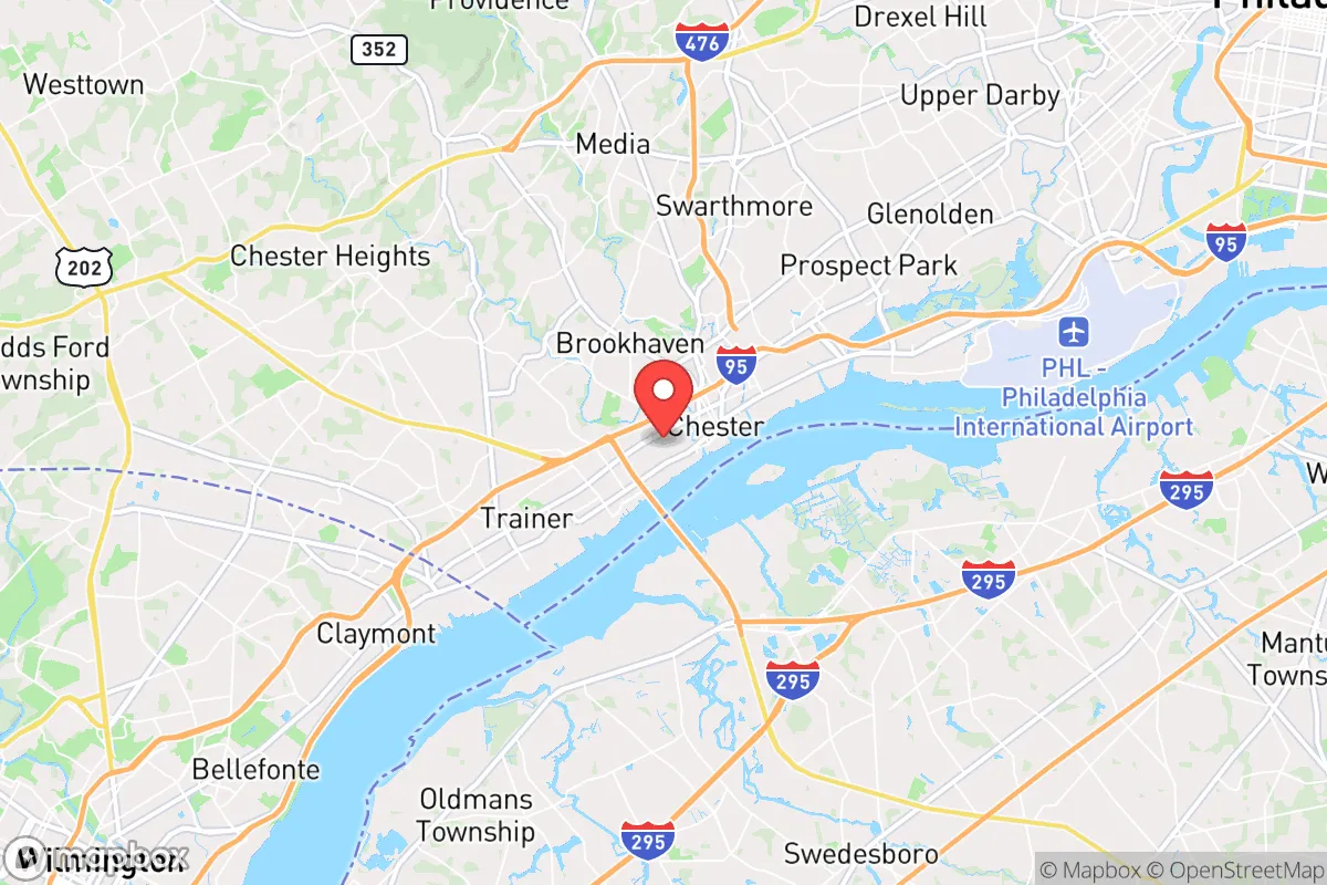
Chester, Pennsylvania, sits in a precarious strategic position that demands a hard-eyed assessment from anyone serious about resilience. Located just 15 miles southwest of Philadelphia along the Delaware River, the city offers proximity to major infrastructure but is also directly in the blast shadow of one of America's densest urban corridors. For a relocator thinking in terms of bug-out routes, supply caches, and defensible ground, Chester presents a mixed bag: genuine geographic advantages for water access and transport, but severe exposure to the cascading failures that would follow a major event in the Northeast Corridor.
Geographic position and natural advantages for a prepper
Chester's location on the Delaware River is its single strongest asset for long-term survival scenarios. The river provides a reliable freshwater source, potential for fishing and small-scale aquaculture, and a natural barrier against ground-based threats from the east. The city sits at the confluence of I-95 and I-476, giving multiple egress routes north toward the Poconos or west toward Lancaster County's agricultural heartland—both critical for a staged retreat. The surrounding terrain is mostly flat coastal plain, which limits natural defensibility but offers good visibility and open ground for gardening or livestock if you secure a rural-adjacent property. The area's moderate climate means fewer extreme weather events that could disrupt supplies, though nor'easters and occasional flooding from the Delaware are real concerns. For a prepper, the key advantage here is water access and multiple highway corridors that allow you to move people and gear quickly if you have to leave.
Risks, exposures, and proximity to fallout-relevant landmarks
The downsides are substantial and cannot be glossed over. Chester is within the immediate fallout zone of Philadelphia, a city of 1.6 million people that would become a humanitarian catastrophe zone in any major event—whether a natural disaster, pandemic, or civil unrest. The Philadelphia International Airport is just 7 miles north, making it a likely target for any airborne threat or a choke point for evacuation. The Delaware River itself hosts the Port of Philadelphia and several chemical storage facilities along the waterfront; a release or attack could contaminate the water supply for miles. Chester also sits near the Marcus Hook Industrial Complex, a major petrochemical refining and storage hub, and the Limerick Generating Station nuclear plant is only 25 miles northwest. A worst-case scenario at either facility would render large swaths of Delaware County uninhabitable for weeks or months. The city's own infrastructure is aging—Chester has a history of water main breaks and sewer overflows—meaning local services would fail quickly under stress. For a survivalist, the concentration of industrial and transportation targets within a 20-mile radius is a critical red flag.
Practical resilience for a relocator: food, water, energy, and defensibility
If you're considering Chester as a base, you need a hard plan for self-sufficiency. Municipal water comes from the Delaware River via the Chester Water Authority, but that system is vulnerable to contamination and power loss. You must have a backup water source—a well on your property is ideal, but many urban lots lack that option. Rainwater catchment and a Berkey or similar filter system are non-negotiable. Food access is decent in normal times, with several grocery stores and a farmers' market, but supply chains would snap quickly. You should maintain a 90-day pantry minimum and know how to forage along the riverbanks (cattails, dandelions, and wild berries are available). Energy is a weak point: the grid is old and prone to outages, and natural gas lines run through the area. Solar panels with battery storage are a smart investment, but you'll need to secure them against theft in a breakdown scenario. Defensibility is poor in the dense urban core—row homes and narrow streets make it easy for groups to surround you. The best bet is a property on the western edge of the city, near the Ridley Creek State Park greenbelt, where you have tree cover, a creek, and a buffer from the densest population. Even then, you're only 10 minutes from I-95, which would become a parking lot or a shooting gallery in a crisis. A bug-out vehicle pre-positioned with gear and a secondary location in Lancaster or Chester County's rural townships is essential.
The overall strategic picture for Chester is one of high risk with conditional reward. It offers genuine advantages for a relocator who values water access, multiple evacuation routes, and proximity to agricultural zones—but only if you are willing to invest heavily in hardening your position and have a clear plan for leaving when the situation deteriorates. The city's location in the Philadelphia metroplex means you are betting that the worst won't happen, or that you can outrun it. For a conservative-minded prepper, that is a thin margin. Chester works best as a temporary staging point or a secondary property, not a primary long-term survival homestead. If you are set on the Delaware Valley, look further west toward the Brandywine Valley or north toward the Poconos for better defensibility and lower exposure to the region's many vulnerabilities. Chester's resilience is real but conditional—and the conditions are not in your favor.
* Values derived from national, state, county, city and local statistics and may differ in a specific area. Last updated: 2026-05-01T12:32:20.000Z
Narrative content on this page is AI-generated and may contain mistakes. Verify any details that matter before acting on them.
ReloMaps may earn a commission from affiliate links at no extra cost to you.