Photo: Wikipedia
Strategic Assessment of Archuleta County
Deep buffer from population centers and strategic targets. Low natural disaster risk and minimal exposure to border or coastal threats.
What does the Strategic Assessment tell us?
Our Strategic Assessment grades tactical survivability of an area. Major population centers, military targets, fallout zones, natural disasters, and border exposure all drive risk — lower exposure means a more defensible position in a crisis.
This is heavily inspired by Joel Skousen's Strategic Relocation book. Highly recommended you checkout the book ($)What does this tell us?
Our Strategic Assessment grades tactical survivability of an area. Major population centers, military targets, fallout zones, natural disasters, and border exposure all drive risk — lower exposure means a more defensible position in a crisis.
This is heavily inspired by Joel Skousen's Strategic Relocation book. Highly recommended you checkout the book ($)Strategic Pillars

Key Distances
Strategic Assessment Analysis
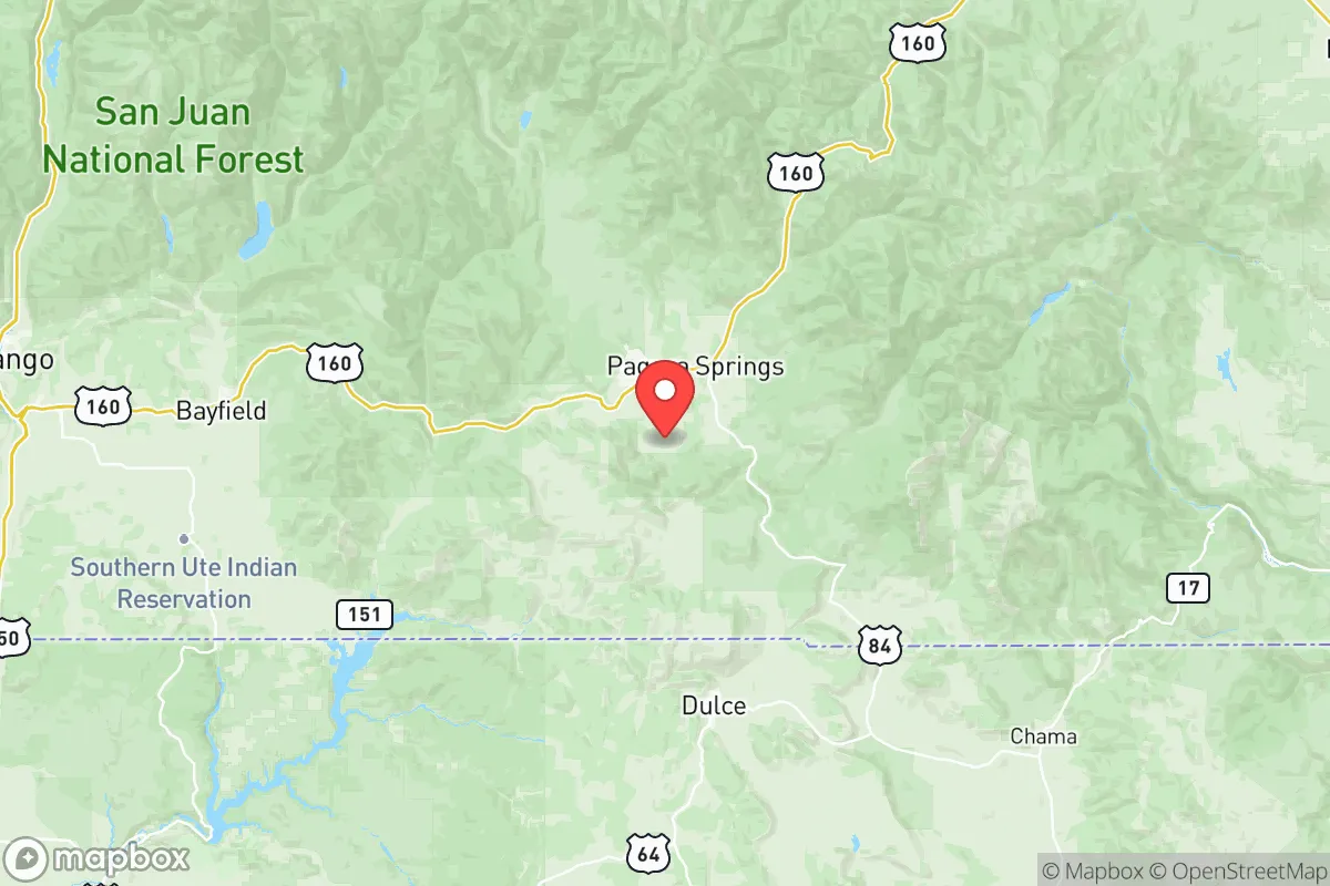
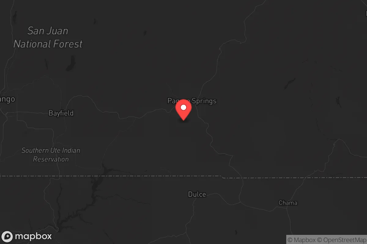
Archuleta County sits in Colorado’s southwest corner with Pagosa Springs as its sole town of real size, offering a combination of deep mountain isolation, abundant water from the San Juan River, and year-round access to the San Juan National Forest. For a relocator assessing resilience, this is one of the most naturally defensible positions in the lower Rockies—far from Front Range pressures and shielded by Wolf Creek Pass to the east and the New Mexico border to the south. The county’s low population density (roughly 14,000 residents over 1,356 square miles) means you won’t be competing for resources in a crisis, and the altitude—running from 6,500 to over 12,000 feet—imposes a natural filter on who can comfortably settle here.
Why Archuleta County’s geography creates a natural buffer zone
Archuleta County is essentially a high mountain valley carved by the San Juan River, with the towering spine of the San Juan Mountains forming its northern and eastern ramparts. This is not flat prairie or open desert—it is a landscape of chokepoints, drainages, and limited ingress. The only paved routes into the county are U.S. Highway 160 from the east over Wolf Creek Pass, U.S. Highway 84 from the south through Chama, New Mexico, and Colorado State Highway 151 from the northwest, connecting to the Southern Ute Indian Reservation. That’s it. Any of these can be monitored or blocked with minimal effort, giving a permanent resident significant defensive leverage.
The San Juan National Forest covers about two-thirds of the county’s land area, providing a vast logistical buffer against urban sprawl. Unlike counties near Denver or Colorado Springs, there is no development pressure pushing inward here—zoning is sparse, land is plentiful, and the existing population is widely scattered among villages like Chromo and Arboles, plus the larger hub of Pagosa Springs. Water is a particular strength: the San Juan River runs through the heart of the county year-round, supplemented by dozens of perennial creeks draining off high country snowpack. In a worst-case scenario involving a grid-down event or regional water contamination, gravity-fed surface water is accessible throughout most of the county’s drainages.
Exposure risks: the Dulce anomaly, energy corridors, and urban proximity
No strategic assessment of Archuleta County is honest without addressing the elephant thirty miles south: Dulce, New Mexico, on the Jicarilla Apache Nation. Dulce has been a recurring topic in intelligence and prepper circles for decades, with persistent reporting of underground infrastructure, unusual activity patterns, and classified research operations. Whether you give the lore any weight or not, the functional reality is that Dulce sits a short drive from Pagosa Springs and contains structures, energy demands, and security protocols that could make it a secondary target in a broader conflict scenario. It is a concentration of unknown risk in an otherwise quiet region.
Beyond Dulce, the wider Four Corners energy corridor introduces a different layer of exposure. The San Juan Generating Station near Farmington—a coal-fired plant that is partially decommissioned but still contains fuel stockpiles and transmission infrastructure—is roughly 70 miles southwest. The Four Corners Power Plant on the Navajo Nation is another 30 miles beyond that. Both are potential targets for sabotage, EMP generation, or kinetic strikes, and plume modeling from a worst-case industrial release at either site would push fallout northeast into the Jemez zone, potentially skirting Archuleta County depending on wind direction. On the nuclear side, Los Alamos National Laboratory lies about 100 miles southeast—sufficiently distant that a direct ground zero event would not immediately threaten the county, but close enough that an atmospheric release or mass evacuation of Santa Fe and Los Alamos would send refugees up the Chama and Rio Grande corridors toward Colorado.
Closer to home, Durango, Colorado sits roughly 60 miles west and is a regional population and transportation hub. Durango would likely experience significant pressure in a crisis—second-home owners, tourists, and panic evacuees from Farmington and the Front Range would flood the Animas Valley quickly. Archuleta County’s position east of Durango means it would absorb some of that overflow, but the physical geography (the La Plata Mountains and the narrow Animas corridor) slows movement enough that a prepared resident would have advance warning and options to harden their position or relocate deeper into the San Juans.
Practical prepper considerations: water, food, energy, and defensibility
Water is Archuleta County’s strongest card. The San Juan River gauge at Pagosa Springs records an average annual flow of roughly 600 cubic feet per second, meaning a resident with property on or near the river has year-round access to running water for drinking, irrigation, and hydroelectric generation if the slope is right. Most of the county’s domestic supply relies on groundwater wells, and the San Juan Basin aquifer is generally productive at depths of
* Values derived from national, state, county, city and local statistics and may differ in a specific area. Last updated: 2026-06-01T14:46:28.000Z
Narrative content on this page is AI-generated and may contain mistakes. Verify any details that matter before acting on them.
ReloMaps may earn a commission from affiliate links at no extra cost to you.