Photo: Wikipedia
Strategic Assessment of Teller County
Workable tactical position. Some exposure to population density or targets, but generally defensible in a crisis.
What does the Strategic Assessment tell us?
Our Strategic Assessment grades tactical survivability of an area. Major population centers, military targets, fallout zones, natural disasters, and border exposure all drive risk — lower exposure means a more defensible position in a crisis.
This is heavily inspired by Joel Skousen's Strategic Relocation book. Highly recommended you checkout the book ($)What does this tell us?
Our Strategic Assessment grades tactical survivability of an area. Major population centers, military targets, fallout zones, natural disasters, and border exposure all drive risk — lower exposure means a more defensible position in a crisis.
This is heavily inspired by Joel Skousen's Strategic Relocation book. Highly recommended you checkout the book ($)Strategic Pillars

Key Distances
Strategic Assessment Analysis
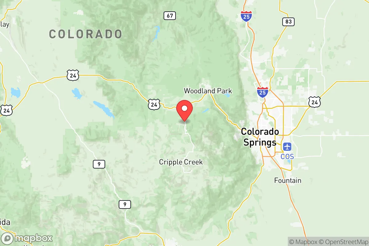
Teller County, Colorado, sits in a strategic sweet spot that’s hard to beat for anyone thinking long-term about resilience. Perched on the western slope of the Front Range, it offers a rare combination of altitude, isolation, and access—close enough to Colorado Springs for resupply and medical care, but far enough to avoid the chaos of a major metro area. The county’s rugged terrain and low population density (roughly 25,000 residents spread over 559 square miles) make it a natural buffer against the kind of cascading failures that plague urban centers. For a relocator with an eye on preparedness, this isn’t just a pretty mountain retreat—it’s a defensible position with real strategic value.
Geographic position and natural advantages for long-term security
Teller County’s geography is its primary asset. The county sits at an average elevation of 8,000 to 10,000 feet, with the town of Woodland Park (the county seat) perched at 8,465 feet. That altitude alone provides a natural defensive layer—approaches are limited, and the cold, thin air discourages casual visitors. The county is bisected by U.S. Highway 24, which runs east-west from Colorado Springs to the high country, but most of the land is national forest (Pike National Forest covers a huge chunk) or private ranchland. This means limited road networks and plenty of choke points. The Florissant Fossil Beds National Monument and the Cripple Creek area offer additional buffer zones of protected land. For a prepper, this is ideal: you can monitor the few access routes, and the terrain itself slows down any large-scale movement. The county also sits on the eastern edge of the San Isabel National Forest, giving you a backdoor into even more remote wilderness if things go sideways.
Risks, exposures, and proximity to fallout-relevant landmarks
No location is perfect, and Teller County has its share of vulnerabilities. The biggest concern is proximity to Colorado Springs, about 20 miles east of Woodland Park. Colorado Springs is home to Peterson Space Force Base, Schriever Space Force Base, and Fort Carson—all high-value military targets in a major conflict. A nuclear or EMP strike on those installations would put Teller County in the fallout zone, depending on wind patterns. The county is also within 50 miles of the U.S. Air Force Academy and the Cheyenne Mountain Complex, a hardened NORAD facility. While the mountains provide some shielding, prevailing westerly winds could carry fallout from a strike on Colorado Springs directly into the county. On the plus side, Teller County has no major industrial targets of its own—no refineries, no ports, no chemical plants. The nearest refinery is in Commerce City, near Denver, over 100 miles north. The county’s main risk is being downwind of a strike on the Springs, not being a target itself. For a relocator, this means you need a solid fallout shelter and a plan to seal up for 72 hours post-event. The good news: the county’s granite bedrock and abundant caves (like those near Cripple Creek) offer natural shielding if you know where to look.
Practical resilience for a relocator: food, water, energy, and defensibility
When it comes to daily survival logistics, Teller County punches above its weight. Water is the first concern, and the county has it in spades. The South Platte River headwaters run through the northern part of the county, and numerous creeks and springs feed off the Pikes Peak massif. Woodland Park gets its municipal water from deep wells and the Rampart Range reservoirs, but for a relocator, the real value is in the private wells and surface water access. Most rural properties have their own wells, and the water table is reliable at depth. Food is trickier. The growing season is short—about 90 days at 8,000 feet—so you’re looking at cold-hardy crops like potatoes, kale, and root vegetables. Cripple Creek and Victor have some small-scale agriculture, but the county is not a breadbasket. You’ll need to stockpile non-perishables or plan for greenhouse growing. Energy is a bright spot. Solar works well here—the county averages 300 sunny days a year—and many off-grid homes already have solar arrays with battery backup. Wood heat is also viable, with national forest access for firewood (permit required). Defensibility is where Teller County really shines. The terrain is steep and forested, with limited ingress points. U.S. Highway 24 is the main artery, and it can be blocked at several narrow canyons. The county’s small population means you can know your neighbors—and in a crisis, that’s worth more than any fence. The Teller County Sheriff’s Office is well-regarded and responsive, but in a grid-down scenario, you’re on your own. The county’s Emergency Management office runs regular preparedness drills, and the local culture is heavily tilted toward self-reliance.
The overall strategic picture for Teller County is one of high reward with manageable risk. It’s not a bug-out location for the faint of heart—the altitude, cold, and isolation demand real preparation. But for a relocator who’s serious about resilience, it offers a rare combination of natural defenses, water security, and distance from the worst fallout zones. The proximity to Colorado Springs is a double-edged sword: it gives you access to supplies and medical care in peacetime, but it’s a liability in a major conflict. If you can build a fallout shelter and stockpile for a few weeks of isolation, Teller County is one of the better bets in the lower 48. The key is to get there before the crowd does—because once the balloon goes up, everyone with a map will be looking at these mountains.
* Values derived from national, state, county, city and local statistics and may differ in a specific area. Last updated: 2026-05-24T13:22:03.000Z
Narrative content on this page is AI-generated and may contain mistakes. Verify any details that matter before acting on them.
ReloMaps may earn a commission from affiliate links at no extra cost to you.