
Photo: Wikipedia
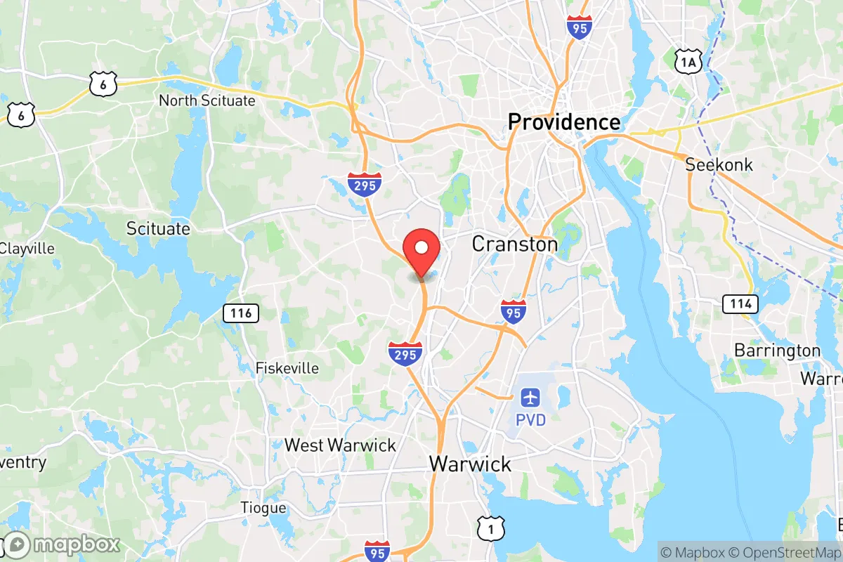
Strategic Assessment of Cranston, RI
Multiple tactical vulnerabilities. Population density, target proximity, or disaster risk are likely compounding. A retreat property and exit planning is required.
What does the Strategic Assessment tell us?
Our Strategic Assessment grades tactical survivability of an area. Major population centers, military targets, fallout zones, natural disasters, and border exposure all drive risk — lower exposure means a more defensible position in a crisis.
This is heavily inspired by Joel Skousen's Strategic Relocation book. Highly recommended you checkout the book ($)What does this tell us?
Our Strategic Assessment grades tactical survivability of an area. Major population centers, military targets, fallout zones, natural disasters, and border exposure all drive risk — lower exposure means a more defensible position in a crisis.
This is heavily inspired by Joel Skousen's Strategic Relocation book. Highly recommended you checkout the book ($)Strategic Pillars

Key Distances
Regional Safe Places
Below is our recommended "safe zones" in Rhode Island and the surrounding area based on our strategic heuristics. For most people, it's unrealistic to live in a “safe zone” full-time due to work, family or other personal reasons. They tend to be more rural. However, many of these areas are perfect for second homes and retreat properties that double as a vacation home or even a short-term rental.


Important Note: For informational purposes only. This does not mean nothing bad ever happens in the green zones. Please use common sense. This is based on public data and modeled with AI. We tried to take a conservative approach but mistakes happen. We update this regularly as new information becomes available.
Solar Generator Recommendations
Backup power matters more here than in safer locations. We've picked three solar generators across budgets and capacity tiers — start with the budget unit if you only need a few essentials, or step up if you want to run a fridge and HVAC for days at a time.

Jackery Portable Power Station Explorer 300
Budget OptionPower on the Go: Weighing only 11 lbs, it's convenient to set up and store with book-sized foldable solar panels

BLUETTI Portable Power Station AC180
Designed for both indoor and outdoor scenarios, AC180 is highly capable as it has a robost capacity and continuous output power.

EF ECOFLOW DELTA Pro Ultra Power Station
Upgraded PickEcoFlow DELTA Pro Ultra is a whole-home energy system designed to grow with your family. Integrated with the Smart Home Panel 2, it scales to meet your evolving energy needs — keeping your home powered, intelligent, and secure through every stage of life.
We earn a commission, at no additional cost to you.
Strategic Assessment Analysis
Cranston, Rhode Island, presents a mixed bag for the strategic relocator. Its proximity to Providence and the Boston-Washington corridor is a significant liability in a crisis scenario, but its position on Narragansett Bay and within a state with a strong, if often overlooked, agricultural and maritime history offers some genuine resilience advantages. For the conservative prepper, this is not a bug-out paradise, but a location that demands a clear-eyed assessment of its vulnerabilities and a deliberate plan to mitigate them. The key question is whether its access to water and local food networks outweighs the undeniable risks of being in a densely populated, politically blue state with a major city just a few miles away.
Geographic position and natural advantages for long-term sustainability
Cranston’s primary strategic asset is its access to water. The Pawtuxet River runs through the city, and the entire area is within the Narragansett Bay watershed. This means a potential source of fresh water for filtration and small-scale agriculture, though it is not pristine and will require robust treatment. The city’s location on the bay also provides access to marine resources—shellfish, finfish, and seaweed—that could supplement food supplies in a prolonged disruption. The local climate, while humid and prone to nor’easters, supports a long growing season for temperate crops. The soil in the western parts of the city, near the Scituate Reservoir and the rural towns of Foster and Scituate, is better for gardening than the urbanized eastern half. For a relocator willing to invest in a property with a well and some land, the western edge of Cranston offers a defensible buffer from the denser population centers to the east. The presence of the Scituate Reservoir, which supplies drinking water to much of Providence County, is a double-edged sword: it is a critical resource, but also a potential target for contamination or sabotage.
Risks, exposures, and proximity to fallout-relevant landmarks
The most glaring vulnerability is Cranston’s location within the Providence metropolitan area. In a scenario of civil unrest, mass casualty events, or a major disaster, the city would be directly affected by the chaos emanating from Providence, just 10 miles north. The I-95 corridor, which runs through the eastern edge of Cranston, is a primary evacuation and supply route that would become a choke point or a target. The city is also within the fallout zone of the Pilgrim Nuclear Power Station in Plymouth, Massachusetts (about 40 miles northeast), and the Seabrook Station in New Hampshire (about 60 miles north). While a full meltdown is a low-probability event, the risk is real and the evacuation plans for the region are notoriously inadequate for a mass exodus. Furthermore, Cranston is home to the Rhode Island National Guard’s Camp Fogarty and the state’s primary emergency management headquarters, making it a likely staging area for government response—which could attract unwanted attention or become a target itself. The city’s industrial history, including former manufacturing sites and a current waste-to-energy plant, means localized environmental hazards are present. The densely populated eastern half of the city, with its older housing stock and grid-like streets, offers little defensibility and would be a liability in a breakdown of order.
Practical resilience for a relocator: food, water, energy, and defensibility
For a relocator willing to invest in a property in the western, more rural parts of Cranston (near the Scituate line), the picture improves. Water is the most critical factor: a property with a private well and a backup hand pump is non-negotiable. The city’s municipal water supply is vulnerable to contamination and disruption, so self-sufficiency is paramount. Food production is feasible with a good garden, a greenhouse, and access to the bay for fishing and shellfish. The local farmers’ markets and the Rhode Island food system, while not robust, are better than in many urban areas. Energy resilience is a challenge. The grid is old and vulnerable to storms. Solar panels with battery storage are a wise investment, but the region’s cloudy winters mean a backup generator (preferably diesel or propane) is essential. Defensibility is poor in the city proper, but a property on a dead-end road with good sightlines and a defensible perimeter in the western part of the city is possible. The key is to avoid the dense neighborhoods near the mall, the airport, and the major highways. Community is a wildcard. Cranston has a mix of long-time Italian and Irish families, newer immigrant communities, and a growing number of out-of-state transplants. Finding like-minded, self-reliant neighbors will require deliberate effort, but the local gun culture is present, and there are shooting ranges and sporting goods stores that serve as informal gathering points for the preparedness-minded.
The overall strategic picture for Cranston is one of calculated risk. It is not a remote retreat, but it offers a unique combination of water access, agricultural potential, and proximity to a major city that could be leveraged in a crisis—if you are prepared to deal with the downsides. The city’s location within a blue state with a strong government presence means that in a major event, you will be dealing with state-level directives and potential restrictions on movement and resources. For the conservative prepper, the calculus is this: Cranston is a viable option only if you secure a property with a well, a defensible layout, and a plan to be self-sufficient for at least 90 days. The risks from Providence, nuclear plants, and the general density of the Northeast Corridor are real and cannot be ignored. If you are looking for a place to ride out a short-term disruption with access to urban amenities, Cranston might work. If you are planning for a long-term collapse, you are better off looking further west, into the rural parts of Rhode Island or into Connecticut. But for the strategic relocator who wants to be near the coast, has the resources to harden a property, and is willing to accept the trade-offs, Cranston offers a narrow but real path to resilience.
* Values derived from national, state, county, city and local statistics and may differ in a specific area. Last updated: 2026-04-21T07:16:37.000Z
Narrative content on this page is AI-generated and may contain mistakes. Verify any details that matter before acting on them.
ReloMaps may earn a commission from affiliate links at no extra cost to you.