
Photo: Wikipedia
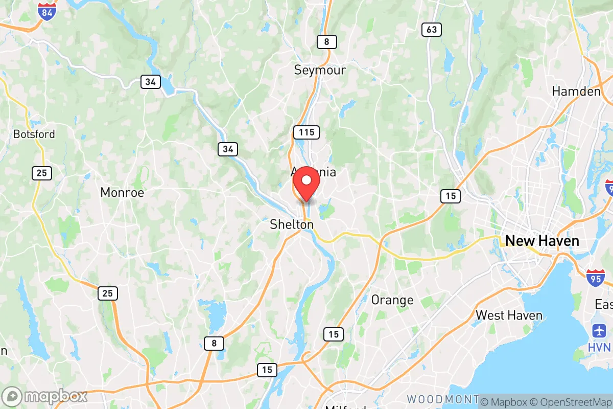
Strategic Assessment of Derby, CT
Multiple tactical vulnerabilities. Population density, target proximity, or disaster risk are likely compounding. A retreat property and exit planning is required.
What does the Strategic Assessment tell us?
Our Strategic Assessment grades tactical survivability of an area. Major population centers, military targets, fallout zones, natural disasters, and border exposure all drive risk — lower exposure means a more defensible position in a crisis.
This is heavily inspired by Joel Skousen's Strategic Relocation book. Highly recommended you checkout the book ($)What does this tell us?
Our Strategic Assessment grades tactical survivability of an area. Major population centers, military targets, fallout zones, natural disasters, and border exposure all drive risk — lower exposure means a more defensible position in a crisis.
This is heavily inspired by Joel Skousen's Strategic Relocation book. Highly recommended you checkout the book ($)Strategic Pillars

Key Distances
Regional Safe Places
Below is our recommended "safe zones" in Connecticut and the surrounding area based on our strategic heuristics. For most people, it's unrealistic to live in a “safe zone” full-time due to work, family or other personal reasons. They tend to be more rural. However, many of these areas are perfect for second homes and retreat properties that double as a vacation home or even a short-term rental.


Important Note: For informational purposes only. This does not mean nothing bad ever happens in the green zones. Please use common sense. This is based on public data and modeled with AI. We tried to take a conservative approach but mistakes happen. We update this regularly as new information becomes available.
Solar Generator Recommendations
Backup power matters more here than in safer locations. We've picked three solar generators across budgets and capacity tiers — start with the budget unit if you only need a few essentials, or step up if you want to run a fridge and HVAC for days at a time.

Jackery Portable Power Station Explorer 300
Budget OptionPower on the Go: Weighing only 11 lbs, it's convenient to set up and store with book-sized foldable solar panels

BLUETTI Portable Power Station AC180
Designed for both indoor and outdoor scenarios, AC180 is highly capable as it has a robost capacity and continuous output power.

EF ECOFLOW DELTA Pro Ultra Power Station
Upgraded PickEcoFlow DELTA Pro Ultra is a whole-home energy system designed to grow with your family. Integrated with the Smart Home Panel 2, it scales to meet your evolving energy needs — keeping your home powered, intelligent, and secure through every stage of life.
We earn a commission, at no additional cost to you.
Strategic Assessment Analysis
Derby, Connecticut, sits in a precarious but potentially strategic pocket of the lower Naugatuck Valley, offering a mix of natural chokepoints and industrial-era infrastructure that could serve a prepared relocator well—if they understand its limits. This small city of roughly 12,000 people is wedged between the Housatonic and Naugatuck Rivers, just 10 miles from the Long Island Sound and about 60 miles from New York City. For someone with a survivalist or prepper mindset, Derby’s location is a double-edged sword: close enough to major population centers to be a concern during unrest, but with enough geographic insulation and local resources to make it a viable fallback position if you’re willing to work around its vulnerabilities.
Geographic position and natural advantages for a prepared relocator
Derby’s position at the confluence of the Housatonic and Naugatuck Rivers gives it a natural defensive layout that’s hard to replicate in flatter parts of the state. The city is built on a series of hills and ridges, with the downtown core sitting in a narrow valley that can be easily monitored or blocked. The Housatonic River to the west and the Naugatuck to the east create a natural moat effect—any approach from those directions requires crossing a bridge, which could be controlled or denied in a crisis. The surrounding towns of Ansonia, Shelton, and Seymour form a ring of similar terrain, meaning Derby isn’t isolated but is part of a network of small, defensible communities. The nearby Indian Well State Park and the Paugussett State Forest offer immediate access to wooded cover, game, and water sources, though you’d need to be familiar with the trails and seasonal flooding patterns. The Housatonic itself is a reliable water source, but it’s also a vector for contamination from upstream industrial sites—something a prepper would need to plan for with filtration or alternative wells.
Risks, exposures, and proximity to fallout-relevant landmarks
The biggest liability for Derby is its proximity to New York City and the I-95 corridor. In a mass casualty event, civil unrest, or grid-down scenario, you’re looking at a potential flow of refugees or looters heading north along Route 8 and Route 34, both of which run directly through Derby. The city is also within 15 miles of the Bridgeport-Port Jefferson ferry terminal and the Stratford Army Engine Plant (now largely decommissioned but still a Superfund site), meaning any coastal disruption—whether from a hurricane, terrorist attack, or industrial accident—could ripple inland quickly. The Naugatuck River valley has a history of flooding, with the 1955 floods being a worst-case example; modern infrastructure has improved drainage, but a prolonged power outage could leave low-lying areas like the downtown and the Derby-Shelton bridge zone underwater. On the fallout front, Derby is roughly 20 miles from the Millstone Nuclear Power Station in Waterford, Connecticut. While that’s outside the typical 10-mile emergency planning zone, prevailing winds from the south could carry a plume up the Housatonic Valley, making a radiation detection kit and a pre-planned evacuation route to the northwest (toward the Litchfield Hills) a non-negotiable part of any preparedness plan.
Practical resilience for a relocator: food, water, energy, and defensibility
For a single individual or family looking to hunker down, Derby offers a mixed bag. The city has a working municipal water system fed by the Housatonic, but it’s vulnerable to both contamination and pump failure. A drilled well on private property is the gold standard here, and many older homes in the hills above downtown already have them—check the deed before buying. The local soil is rocky but workable for raised-bed gardening, and the growing season runs from late April to early October, long enough for tomatoes, squash, and root vegetables. The nearby Shelton Farmers Market and local CSAs provide a backup supply chain during normal times, but in a crisis, you’d want to have at least a year’s worth of non-perishables stored. Energy-wise, Derby is served by Eversource, which has a mixed reliability record during storms. Solar panels with battery backup are feasible on south-facing roofs in the hills, but the tree cover in many neighborhoods limits exposure. A propane generator with a 500-gallon tank is a more practical bet for most properties. Defensibility is where Derby shines: the hilltop neighborhoods like Pine Street and the area around Derby High School offer clear sightlines over the valley, and the narrow road network means any approach can be observed or blocked. The local police department is small (about 30 officers), so in a prolonged breakdown, you’d be relying on neighborhood mutual aid—something the existing community of long-term residents, many of whom are of Italian and Polish descent with deep roots, already practices informally. The Derby Neck Library and the city’s senior center could serve as community coordination points, but you’d want to establish relationships before a crisis hits.
The overall strategic picture for Derby is one of cautious viability. It’s not a remote bunker location—you’re still within an hour of 3 million people, and the risks from coastal fallout, flooding, and refugee flow are real. But for someone who values proximity to natural resources, defensible terrain, and a tight-knit community that doesn’t panic easily, Derby offers a base that can be hardened with moderate effort. The key is to treat it as a forward operating position rather than a final redoubt: have a bug-out plan for the Litchfield Hills or the Berkshires if things go truly sideways, but know that Derby’s hills and rivers give you a fighting chance to ride out the first wave of disruption. If you’re willing to invest in water independence, energy storage, and local networking, this small city on the Housatonic can be a solid anchor for a prepared life in an uncertain decade.
* Values derived from national, state, county, city and local statistics and may differ in a specific area. Last updated: 2026-04-30T05:21:07.000Z
Narrative content on this page is AI-generated and may contain mistakes. Verify any details that matter before acting on them.
ReloMaps may earn a commission from affiliate links at no extra cost to you.