Photo: Wikipedia
Strategic Assessment of Dunwoody, GA
Multiple tactical vulnerabilities. Population density, target proximity, or disaster risk are likely compounding. A retreat property and exit planning is required.
What does the Strategic Assessment tell us?
Our Strategic Assessment grades tactical survivability of an area. Major population centers, military targets, fallout zones, natural disasters, and border exposure all drive risk — lower exposure means a more defensible position in a crisis.
This is heavily inspired by Joel Skousen's Strategic Relocation book. Highly recommended you checkout the book ($)What does this tell us?
Our Strategic Assessment grades tactical survivability of an area. Major population centers, military targets, fallout zones, natural disasters, and border exposure all drive risk — lower exposure means a more defensible position in a crisis.
This is heavily inspired by Joel Skousen's Strategic Relocation book. Highly recommended you checkout the book ($)Strategic Pillars

Key Distances
Regional Safe Places
Below is our recommended "safe zones" in Georgia and the surrounding area based on our strategic heuristics. For most people, it's unrealistic to live in a “safe zone” full-time due to work, family or other personal reasons. They tend to be more rural. However, many of these areas are perfect for second homes and retreat properties that double as a vacation home or even a short-term rental.


Important Note: For informational purposes only. This does not mean nothing bad ever happens in the green zones. Please use common sense. This is based on public data and modeled with AI. We tried to take a conservative approach but mistakes happen. We update this regularly as new information becomes available.
Solar Generator Recommendations
Backup power matters more here than in safer locations. We've picked three solar generators across budgets and capacity tiers — start with the budget unit if you only need a few essentials, or step up if you want to run a fridge and HVAC for days at a time.

Jackery Portable Power Station Explorer 300
Budget OptionPower on the Go: Weighing only 11 lbs, it's convenient to set up and store with book-sized foldable solar panels

BLUETTI Portable Power Station AC180
Designed for both indoor and outdoor scenarios, AC180 is highly capable as it has a robost capacity and continuous output power.

EF ECOFLOW DELTA Pro Ultra Power Station
Upgraded PickEcoFlow DELTA Pro Ultra is a whole-home energy system designed to grow with your family. Integrated with the Smart Home Panel 2, it scales to meet your evolving energy needs — keeping your home powered, intelligent, and secure through every stage of life.
We earn a commission, at no additional cost to you.
Strategic Assessment Analysis
Dunwoody, Georgia, sits in a precarious strategic position that demands serious consideration from anyone prioritizing long-term resilience. While its location within metro Atlanta offers economic advantages, the same proximity to a major urban center introduces significant vulnerabilities for those preparing for civic unrest, infrastructure collapse, or mass casualty events. For the conservative-minded relocator, Dunwoody presents a mixed picture: it has some natural defensive characteristics, but its fundamental reliance on regional systems and its proximity to high-value targets make it a location that requires careful, sober assessment rather than blind optimism.
Geographic position and natural defensive advantages
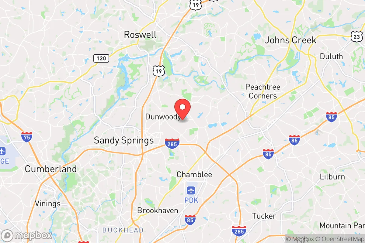
Dunwoody occupies a roughly 10-square-mile area in northern DeKalb County, positioned along the Chattahoochee River corridor. The area sits on the Piedmont plateau, with rolling hills and moderate elevation changes that provide some natural observation points and defensible terrain, though nothing approaching mountainous security. The Chattahoochee River National Recreation Area runs along Dunwoody’s western edge, offering a significant water source and a natural barrier that could slow movement from the west. The river’s proximity means groundwater tables are generally higher here than in surrounding areas, which matters for well viability. Dunwoody’s tree canopy is substantial—over 50% coverage according to city planning data—providing concealment and reducing heat island effects during prolonged power outages. The area’s position on the Eastern Continental Divide means stormwater drainage is efficient, reducing flood risk compared to lower-lying parts of metro Atlanta. However, the terrain is not rugged enough to provide serious defensive depth; a determined group could traverse these hills with minimal difficulty.
Risks, exposures, and proximity to fallout-relevant landmarks
The most significant strategic liability for Dunwoody is its location within the Atlanta metropolitan area, home to over 6 million people. Dunwoody sits roughly 15 miles north of downtown Atlanta, placing it within the blast and fallout zone of any major attack on the city’s infrastructure. Key targets within a 20-mile radius include Hartsfield-Jackson Atlanta International Airport (the world’s busiest), CDC headquarters, multiple military installations (Dobbins ARB, Fort Gillem, Fort McPherson), and the Georgia Power nuclear plants at Plant Vogtle and Plant Hatch (though these are farther out, fallout patterns could reach Dunwoody depending on wind). The Perimeter Center business district, which includes major corporate headquarters like UPS, Cox Enterprises, and State Farm, is a potential target for economic disruption. Dunwoody is also crisscrossed by I-285 and GA-400, two major evacuation routes that would become impassable chokepoints during any crisis. The city’s population density of roughly 3,500 people per square mile means that even a partial evacuation would create gridlock. For the prepper, the risk of being caught in a mass exodus from Atlanta is real—Dunwoody sits directly in the path of anyone fleeing north on GA-400 or east on I-285.
Practical resilience for a relocator: food, water, energy, and defensibility
For someone serious about self-sufficiency, Dunwoody presents challenges. Water access is the most critical issue. The city’s water comes from the Chattahoochee River via DeKalb County’s system, which is vulnerable to contamination, pump failure, or targeted disruption. While the river itself is a viable surface water source, accessing it requires crossing busy roads or private property. Well water is rare in Dunwoody due to the area’s suburban development; most homes are on municipal supply. Rainwater collection is feasible given the region’s 50+ inches of annual rainfall, but HOAs and city codes may restrict cistern installation. Food production is limited by lot sizes—typical Dunwoody homes sit on 0.25 to 0.5 acres, enough for a substantial garden but not for true agricultural self-sufficiency. The growing season runs from April to October, allowing for two crop cycles, but soil quality varies and many lots are shaded by mature hardwoods. Energy resilience is mixed: Georgia Power’s grid is relatively reliable, but the area is prone to ice storms and summer thunderstorms that cause outages. Solar potential is moderate—the tree canopy limits direct sun exposure on many properties. Natural gas is widely available for backup heating and cooking. Defensibility is poor in a suburban grid layout; most neighborhoods have multiple entry points and are not designed for perimeter security. The best options for a relocator would be a home on a cul-de-sac with a single access point, preferably with a basement for shelter and storage. Firearms laws in Georgia are favorable—constitutional carry is legal, and there are no state-level magazine restrictions—but DeKalb County has more restrictive local ordinances than surrounding counties.
The overall strategic picture for a conservative relocator
Dunwoody is not a location for the hardcore survivalist seeking remote self-sufficiency. Its value lies in its economic stability and community infrastructure during normal times, combined with a moderate ability to weather short-term disruptions. For the conservative relocator who needs to remain employed in metro Atlanta but wants a base that can handle a week-long power outage, a civil unrest event, or a localized disaster, Dunwoody is workable. The strong local police force and low crime rates (violent crime is roughly half the national average) provide a baseline of security that many urban-adjacent suburbs lack. The active community emergency response team (CERT) and neighborhood watch programs indicate a population that takes preparedness seriously. However, the fundamental reality is that Dunwoody is too close to too many targets for anyone planning for a long-term collapse scenario. The smart play for a relocator is to use Dunwoody as a primary residence with a bug-out location farther north—toward the North Georgia mountains, where the terrain becomes defensible and population density drops sharply. For the single individual or family who wants to be prepared without living off-grid, Dunwoody offers a reasonable middle ground, provided you have a plan for the day when the Perimeter becomes a parking lot and the sirens start sounding from the south.
* Values derived from national, state, county, city and local statistics and may differ in a specific area. Last updated: 2026-04-23T05:29:43.000Z
Narrative content on this page is AI-generated and may contain mistakes. Verify any details that matter before acting on them.
ReloMaps may earn a commission from affiliate links at no extra cost to you.