Photo: Wikipedia
Strategic Assessment of Elgin, IL
Multiple tactical vulnerabilities. Population density, target proximity, or disaster risk are likely compounding. A retreat property and exit planning is required.
What does the Strategic Assessment tell us?
Our Strategic Assessment grades tactical survivability of an area. Major population centers, military targets, fallout zones, natural disasters, and border exposure all drive risk — lower exposure means a more defensible position in a crisis.
This is heavily inspired by Joel Skousen's Strategic Relocation book. Highly recommended you checkout the book ($)What does this tell us?
Our Strategic Assessment grades tactical survivability of an area. Major population centers, military targets, fallout zones, natural disasters, and border exposure all drive risk — lower exposure means a more defensible position in a crisis.
This is heavily inspired by Joel Skousen's Strategic Relocation book. Highly recommended you checkout the book ($)Strategic Pillars

Key Distances
Regional Safe Places
Below is our recommended "safe zones" in Illinois and the surrounding area based on our strategic heuristics. For most people, it's unrealistic to live in a “safe zone” full-time due to work, family or other personal reasons. They tend to be more rural. However, many of these areas are perfect for second homes and retreat properties that double as a vacation home or even a short-term rental.
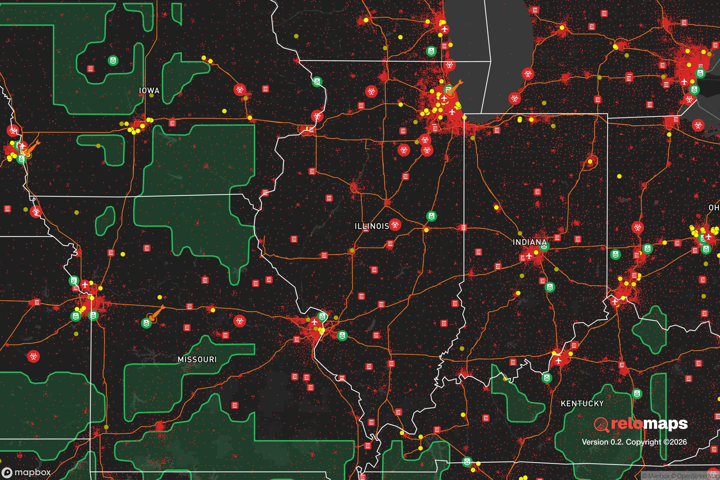
Important Note: For informational purposes only. This does not mean nothing bad ever happens in the green zones. Please use common sense. This is based on public data and modeled with AI. We tried to take a conservative approach but mistakes happen. We update this regularly as new information becomes available.
Solar Generator Recommendations
Backup power matters more here than in safer locations. We've picked three solar generators across budgets and capacity tiers — start with the budget unit if you only need a few essentials, or step up if you want to run a fridge and HVAC for days at a time.

Jackery Portable Power Station Explorer 300
Budget OptionPower on the Go: Weighing only 11 lbs, it's convenient to set up and store with book-sized foldable solar panels

BLUETTI Portable Power Station AC180
Designed for both indoor and outdoor scenarios, AC180 is highly capable as it has a robost capacity and continuous output power.

EF ECOFLOW DELTA Pro Ultra Power Station
Upgraded PickEcoFlow DELTA Pro Ultra is a whole-home energy system designed to grow with your family. Integrated with the Smart Home Panel 2, it scales to meet your evolving energy needs — keeping your home powered, intelligent, and secure through every stage of life.
We earn a commission, at no additional cost to you.
Strategic Assessment Analysis
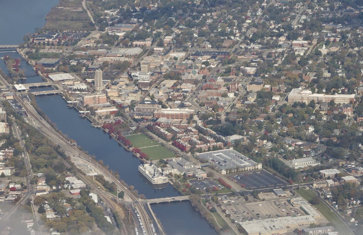
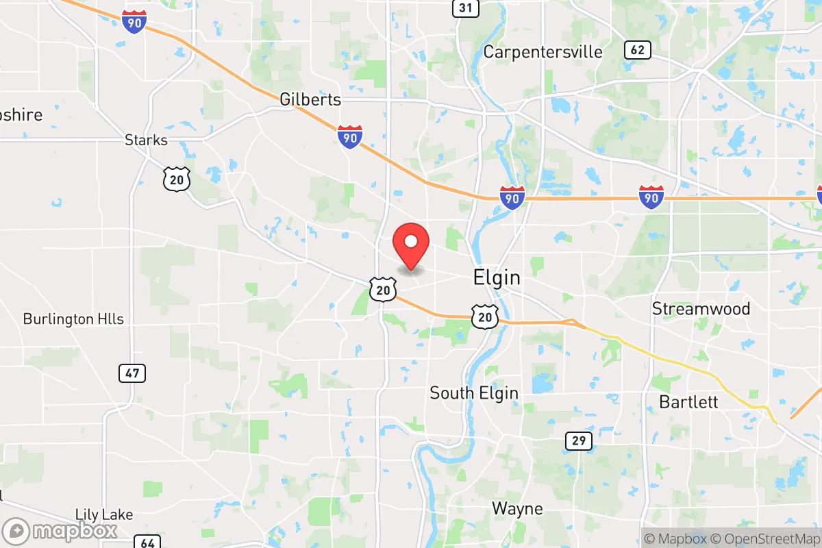
Elgin, Illinois, sits in a precarious strategic position that demands a hard-nosed assessment for anyone serious about long-term resilience. Located roughly 35 miles northwest of Chicago’s Loop and straddling the Fox River, the city offers a mix of suburban infrastructure and access to rural escape routes, but its proximity to a major metropolitan target zone introduces significant vulnerabilities. For the conservative prepper or survivalist, Elgin is a study in trade-offs: decent water resources and a solid grid are offset by choke-point highways, a dense population, and fallout exposure from Chicago’s likely targets. This analysis strips away the marketing gloss and looks at what Elgin actually offers for those planning to weather civic unrest, mass casualty events, or large-scale disasters.
Geographic position and natural advantages for long-term survival
Elgin’s location along the Fox River is its single most valuable natural asset for a prepper. The river provides a reliable surface water source for filtration and irrigation, and the surrounding Kane County landscape includes patches of forest preserves—like the 3,000-acre Burnidge Forest Preserve and the sprawling 1,600-acre Paul Wolff Campground—that offer cover and potential foraging grounds. The area sits on the edge of the Wisconsin Driftless region, meaning the terrain is gently rolling rather than flat, which aids in natural drainage and provides some concealment from line-of-sight threats. The soil in the Fox River Valley is fertile, supporting small-scale agriculture if you can secure land outside the city limits. Elgin’s elevation, around 750 feet above sea level, is modest but enough to avoid the worst flood risks along the river itself, though low-lying neighborhoods near the water remain vulnerable. For a relocator, the key advantage is that Elgin is far enough from Chicago to avoid the immediate blast radius of a nuclear detonation—Chicago’s primary targets (O’Hare, the Loop, military installations) are 30-40 miles away—but close enough that you can monitor urban collapse from a distance. The city’s position along the I-90 corridor also means you have a direct route northwest toward the more sparsely populated areas of McHenry County and southern Wisconsin, which is your primary bug-out path if Elgin itself becomes untenable.
Risks, exposures, and proximity to fallout-relevant landmarks
The downsides of Elgin’s location are substantial and must be weighed honestly. The city’s population of roughly 115,000 is dense by suburban standards, and the surrounding metro area pushes that number past 9 million when you include Chicago’s sprawl. In a mass casualty event or civil unrest scenario, that density translates into competition for resources, looting risks, and a higher probability of disease spread. Elgin is also a transportation hub: the Metra Union Pacific West Line runs directly into Chicago’s Ogilvie Transportation Center, and the I-90/I-290 interchange near the city is a major chokepoint. During a crisis, these routes will clog with evacuees, turning Elgin into a bottleneck rather than a sanctuary. More critically, Elgin lies within the fallout plume zone for several high-value targets. The Fermi 2 nuclear power plant in Newport, Michigan, is about 250 miles east, but closer threats include the Braidwood Generating Station (about 60 miles southwest) and the Dresden Generating Station (about 50 miles southwest). A conventional or terrorist attack on any of these facilities could send radioactive material drifting over Kane County depending on wind patterns. Additionally, Elgin is within 20 miles of the Chicago Rockford International Airport, a potential military logistics hub, and within 40 miles of the Great Lakes Naval Base. These are all secondary targets that increase the likelihood of the area being affected by fallout or military activity. For the survivalist, the takeaway is that Elgin is not a remote retreat—it’s a suburban buffer zone that could become a danger zone if Chicago or its infrastructure is hit.
Practical resilience for a relocator: food, water, energy, and defensibility
On the practical side, Elgin offers a mixed bag for those looking to establish a resilient household. Water is the strongest point: the Fox River is a year-round, flowing source, and the city’s water treatment plant draws from deep wells in the St. Peter Sandstone aquifer, which is less vulnerable to surface contamination than Lake Michigan water. A prepper with a good filtration system (Berkey, Sawyer, or a DIY sand filter) can secure drinking water indefinitely. However, the river is also a liability—it’s a known dumping ground for industrial runoff and agricultural chemicals, so filtration and boiling are non-negotiable. Food security is weak within the city limits. Elgin has a handful of grocery stores (Jewel-Osco, Aldi, Walmart), but these will be stripped within hours of a crisis. The surrounding farmland in Kane and DeKalb counties is productive, but you’ll need land, seeds, and the skills to grow your own—something most suburban lots don’t accommodate. Community gardens exist but are small and likely to be contested. Energy is a vulnerability. Elgin’s grid is tied to ComEd’s regional system, which is aging and prone to outages during storms or cyberattacks. Natural gas lines run through the area, but a prolonged grid-down scenario means you’re reliant on solar, generator, or wood heat. The city’s tree canopy is decent, providing some biomass for heating, but you’ll need a wood stove and a supply chain that doesn’t depend on Home Depot. Defensibility is poor in the urban core. Elgin’s layout is typical of a post-war suburb: cul-de-sacs, strip malls, and a downtown with narrow streets. The best defensive positions are on the outskirts—rural properties along Route 20 or near the Hampshire border—where you have fields of fire and fewer neighbors. Inside the city, you’re looking at a neighborhood watch scenario at best, and a siege mentality at worst. The Kane County Sheriff’s Office is competent but will be overwhelmed in a large-scale event. For a single individual or family, the smart play is to secure a property on the western edge of Elgin, closer to the farmland and away from the I-90 corridor, and to have a bug-out location pre-stocked in Jo Daviess County or southwestern Wisconsin.
The overall strategic picture for Elgin is that it’s a viable intermediate option—not a fortress, but not a death trap either. If you’re looking for a place that balances access to urban resources (medical facilities like Advocate Sherman Hospital, supply chains, and a job market) with a reasonable escape route to rural safety, Elgin fits that niche. But it demands constant vigilance: you are living in the shadow of Chicago’s collapse, and the city’s own density means you cannot afford to be complacent. For the conservative prepper, Elgin is a place to stage, not to settle. Your long-term survival depends on having a plan to move further northwest within the first 72 hours of a major event, using the Fox River as a navigation aid and the rural counties as your ultimate destination. If you’re willing to put in the work—stockpiling supplies, building community with like-minded neighbors, and maintaining a low profile—Elgin can work as a base of operations. But if you’re looking for a true retreat, keep driving another hour west. The Fox River Valley is a buffer zone, not a sanctuary.
* Values derived from national, state, county, city and local statistics and may differ in a specific area. Last updated: 2026-04-29T19:26:55.000Z
Narrative content on this page is AI-generated and may contain mistakes. Verify any details that matter before acting on them.
ReloMaps may earn a commission from affiliate links at no extra cost to you.