Photo: Wikipedia
Strategic Assessment of Volusia County
Meaningful friction. Expect exposure to either population pressure, blast zones, or natural disaster risk. Consider buying a retreat property.
What does the Strategic Assessment tell us?
Our Strategic Assessment grades tactical survivability of an area. Major population centers, military targets, fallout zones, natural disasters, and border exposure all drive risk — lower exposure means a more defensible position in a crisis.
This is heavily inspired by Joel Skousen's Strategic Relocation book. Highly recommended you checkout the book ($)What does this tell us?
Our Strategic Assessment grades tactical survivability of an area. Major population centers, military targets, fallout zones, natural disasters, and border exposure all drive risk — lower exposure means a more defensible position in a crisis.
This is heavily inspired by Joel Skousen's Strategic Relocation book. Highly recommended you checkout the book ($)Strategic Pillars

Key Distances
Strategic Assessment Analysis
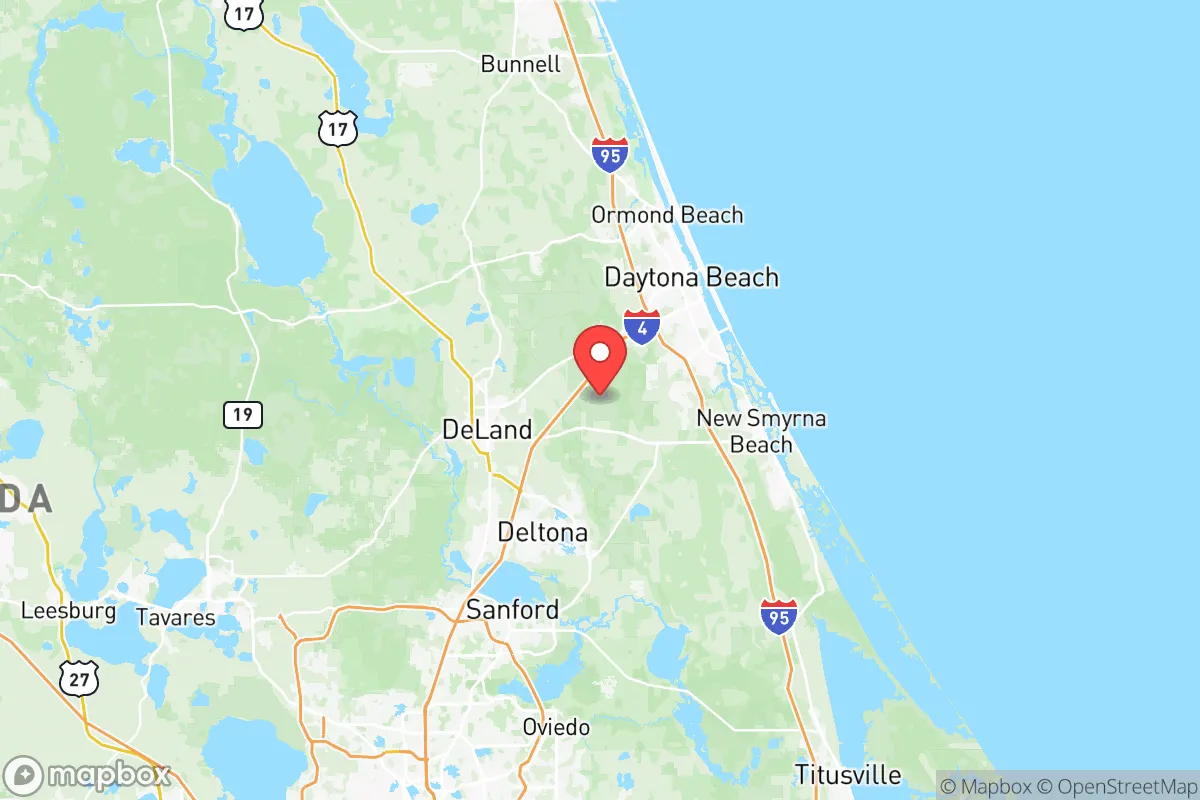
Volusia County, Florida, occupies a strategic middle ground that resilience-minded relocators should study closely: close enough to major infrastructure to supply a retreat, far enough from the highest-risk targets to offer genuine breathing room. Stretching from the Atlantic coast at Daytona Beach inland to the St. Johns River swamp, the county combines coastal access with interior buffer zones, a mix that matters when you’re thinking about supply chains, evacuation routes, and fallout geometry. For a conservative-leaning individual or family weighing long-term security, Volusia’s real advantage isn’t just its beaches—it’s the fact that it sits outside the blast-shadow of Florida’s biggest population centers while still being connected to them by major highways and rail.
Geographic position and natural advantages for a strategic retreat
Volusia County’s layout gives you options. The eastern edge runs along 50 miles of Atlantic coastline, with Daytona Beach, New Smyrna Beach, and Ormond Beach as the main population nodes. But the real strategic value lies inland: the county stretches west to the St. Johns River floodplain, a vast, sparsely populated wetland that acts as a natural barrier to overland movement from the interior. The Tomoka State Forest and Lake George State Forest provide timber, game, and water access that coastal suburbs simply don’t have. Elevation is modest—the highest point is barely 30 feet above sea level—but that’s less of a concern for fallout than for storm surge, and the interior towns like DeLand and DeLeon Springs sit on higher ground well away from the coast. The county is bisected by I-4, which runs from Daytona Beach southwest to Tampa, and I-95, which hugs the coast. That means you can move people and supplies inland quickly if a hurricane or civil unrest hits the beach, but it also means those same highways are evacuation chokepoints. The key takeaway: Volusia offers a layered geography—coastal access for fishing and trade, interior forest for concealment and subsistence, and a river system that can be used for both transport and defense.
Risks, exposures, and proximity to fallout-relevant landmarks
No place in Florida is free of risk, and Volusia has its share. The most obvious exposure is hurricane storm surge along the coast—Daytona Beach and New Smyrna Beach are in the direct path of any major Atlantic storm, and the barrier islands (like Ponce Inlet) are particularly vulnerable. But from a prepper’s perspective, the bigger concern is proximity to targets that could draw secondary effects. Daytona Beach International Airport is a civilian field, but it also hosts the Florida Army National Guard’s 1st Battalion, 111th Aviation Regiment, which operates Black Hawks and Chinooks. That makes it a potential staging area during a crisis—and a potential target if things go kinetic. The county also sits about 60 miles northeast of Orlando, a major population center with theme parks, convention centers, and a massive tourism economy that would become a humanitarian disaster zone during a pandemic, food shortage, or civil unrest. The Cape Canaveral Space Force Station is about 70 miles south—a high-value national security asset that could draw precision strikes or become a no-go zone during a conflict. On the plus side, Volusia has no major refineries, no nuclear power plants (the closest is St. Lucie, 120 miles south), and no major military bases beyond the Guard unit. The county’s risk profile is moderate—not a safe zone, but not a bullseye either. The real danger is the population density along the coast: over 500,000 people in the county, many of them tourists and seasonal residents who would panic and clog roads during an evacuation.
Practical resilience for a relocator: food, water, energy, and defensibility
If you’re serious about self-sufficiency, Volusia has some real strengths and a few glaring weaknesses. Water is abundant: the Floridan Aquifer underlies the entire county, and wells are common in rural areas. The St. Johns River and the Tomoka River provide surface water, though you’ll need to filter and treat it. Rainfall averages about 50 inches a year, so rainwater catchment is viable. Food production is mixed—the interior has sandy soil that’s good for citrus, vegetables, and some row crops, but the coastal strip is mostly development. DeLand and the surrounding agricultural area have working farms, farmers’ markets, and a growing homesteading community. Game is plentiful: deer, wild hogs, turkey, and waterfowl in the forests and marshes. Fishing is excellent in the Intracoastal Waterway and the Atlantic. Energy is where things get tricky. Florida Power & Light runs the grid, and it’s vulnerable to hurricanes and cyberattacks. Solar is viable—the county gets over 230 sunny days a year—but you’ll need battery storage and a backup generator for the inevitable outages. Defensibility is situational. The interior offers good chokepoints: narrow roads through the forest, river crossings, and limited access points to rural subdivisions. The coast is harder to defend—too many beach access points, too many tourists, too much open ground. For a family, the sweet spot is a property in the western half of the county, near DeLand or Pierson, with a well, solar panels, and a buffer of woods or farmland between you and the main roads.
The overall strategic picture for Volusia County is one of calculated trade-offs. It’s not a remote mountain redoubt—you’re still within a day’s drive of Orlando, Jacksonville, and Tampa, and the coast brings hurricane risk and population density. But it’s also not a concrete jungle with no escape route. The county’s real value is as a layered retreat: a place where you can live a normal suburban or rural life during stable times, then fall back to the interior if things go sideways. The presence of the National Guard unit at Daytona Beach is a double-edged sword—it could mean security or it could mean a target, depending on the scenario. The lack of heavy industry and nuclear infrastructure is a clear plus. For a conservative family that wants to stay connected to the broader economy while maintaining the ability to bug in or bug out, Volusia offers a workable balance. Just don’t buy on the beach, don’t rely on the grid, and make sure you’ve got a plan for the I-4/I-95 intersection when the tourists panic. That’s the real threat—not the storm, not the fallout, but the crowd.
* Values derived from national, state, county, city and local statistics and may differ in a specific area. Last updated: 2026-05-28T05:44:06.000Z
Narrative content on this page is AI-generated and may contain mistakes. Verify any details that matter before acting on them.
ReloMaps may earn a commission from affiliate links at no extra cost to you.