Photo: Wikipedia
Strategic Assessment of Folly Beach, SC
Meaningful friction. Expect exposure to either population pressure, blast zones, or natural disaster risk. Consider buying a retreat property.
What does the Strategic Assessment tell us?
Our Strategic Assessment grades tactical survivability of an area. Major population centers, military targets, fallout zones, natural disasters, and border exposure all drive risk — lower exposure means a more defensible position in a crisis.
This is heavily inspired by Joel Skousen's Strategic Relocation book. Highly recommended you checkout the book ($)What does this tell us?
Our Strategic Assessment grades tactical survivability of an area. Major population centers, military targets, fallout zones, natural disasters, and border exposure all drive risk — lower exposure means a more defensible position in a crisis.
This is heavily inspired by Joel Skousen's Strategic Relocation book. Highly recommended you checkout the book ($)Strategic Pillars

Key Distances
Regional Safe Places
Below is our recommended "safe zones" in South Carolina and the surrounding area based on our strategic heuristics. For most people, it's unrealistic to live in a “safe zone” full-time due to work, family or other personal reasons. They tend to be more rural. However, many of these areas are perfect for second homes and retreat properties that double as a vacation home or even a short-term rental.


Important Note: For informational purposes only. This does not mean nothing bad ever happens in the green zones. Please use common sense. This is based on public data and modeled with AI. We tried to take a conservative approach but mistakes happen. We update this regularly as new information becomes available.
Solar Generator Recommendations
Backup power matters more here than in safer locations. We've picked three solar generators across budgets and capacity tiers — start with the budget unit if you only need a few essentials, or step up if you want to run a fridge and HVAC for days at a time.

Jackery Portable Power Station Explorer 300
Budget OptionPower on the Go: Weighing only 11 lbs, it's convenient to set up and store with book-sized foldable solar panels

BLUETTI Portable Power Station AC180
Designed for both indoor and outdoor scenarios, AC180 is highly capable as it has a robost capacity and continuous output power.

EF ECOFLOW DELTA Pro Ultra Power Station
Upgraded PickEcoFlow DELTA Pro Ultra is a whole-home energy system designed to grow with your family. Integrated with the Smart Home Panel 2, it scales to meet your evolving energy needs — keeping your home powered, intelligent, and secure through every stage of life.
We earn a commission, at no additional cost to you.
Strategic Assessment Analysis
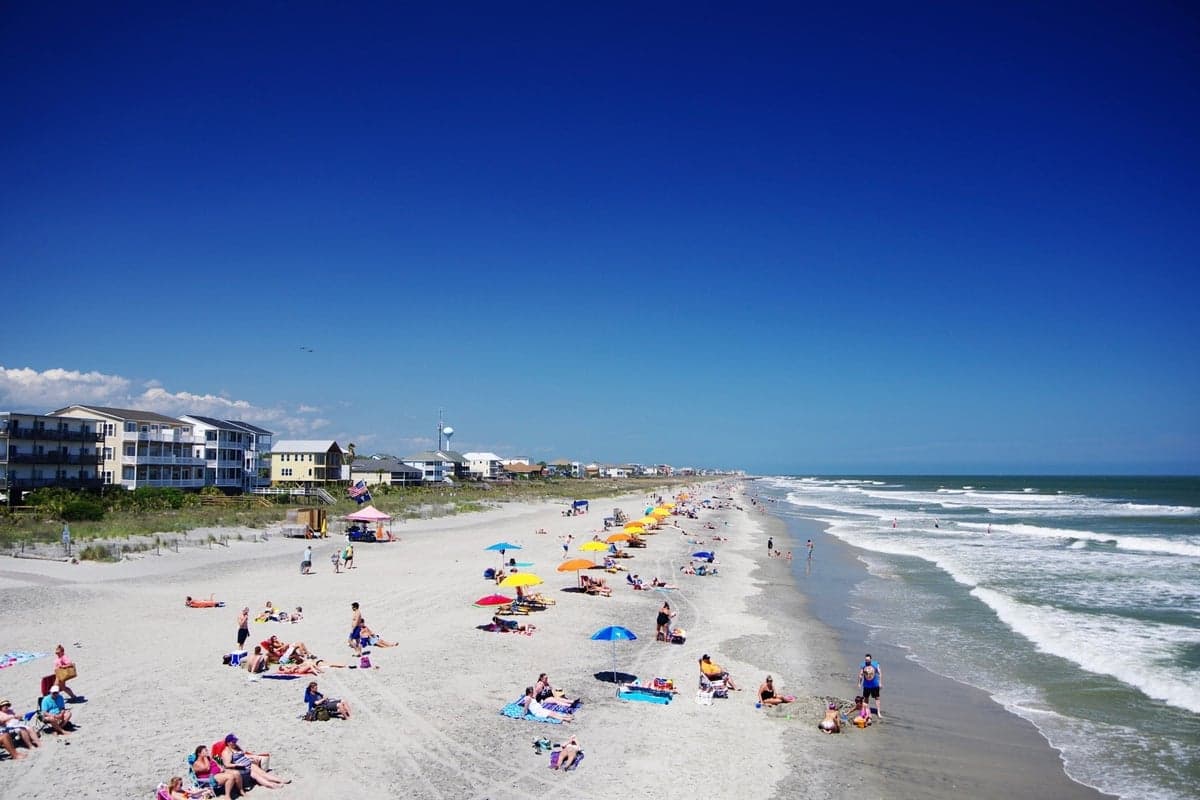
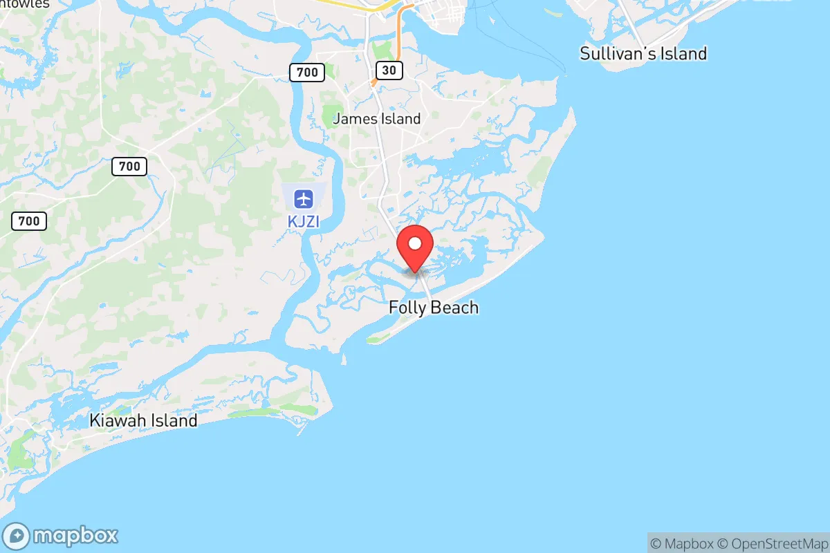
Folly Beach, South Carolina, offers a classic barrier-island setup with natural defensive advantages from the ocean and marsh, but its strategic value for a prepper is severely undermined by its proximity to Charleston and the single-point-of-failure access via Folly Road. The island's geography provides some isolation from the mainland, yet this same geography creates a trap if the bridge is compromised or the coast is hit by a major storm. For a relocator focused on resilience, the trade-off between natural beauty and practical survivability is stark, and the hard truth is that this location works best as a temporary retreat, not a long-term survival hub.
How Folly Beach's island geography helps and hurts your survival plan
Folly Beach sits on a narrow barrier island roughly six miles long and less than a mile wide, with the Atlantic Ocean to the east and the Folly River and salt marsh to the west. This layout gives you a natural buffer on two sides—any approach from the mainland has to cross the marsh or the river, which slows down foot traffic and vehicles alike. The island's elevation averages only about 10 feet above sea level, which means you're exposed to storm surge from hurricanes, and the sandy soil is poor for growing food without serious amendment. The mild coastal climate is a plus for year-round living and could support some gardening if you build raised beds with imported soil, but you're limited by space and the salt spray that kills many crops. The island's small size also means there's nowhere to retreat to internally; if the bridge is cut or the beach is compromised, you're boxed in. Historically, Folly Beach has been evacuated multiple times for hurricanes, and those evacuations are a logistical nightmare—the single road out, SC-171, becomes a parking lot when a storm approaches, and that same bottleneck applies to any crisis that requires leaving the island.
Why Folly Beach's proximity to Charleston is a major strategic liability
This is the dealbreaker for anyone thinking long-term. Folly Beach is roughly 10 miles from downtown Charleston, a city with a major deep-water port, a naval base, and a population of over 150,000 in the city proper and nearly 800,000 in the metro area. In any scenario involving civil unrest, mass casualty events, or geopolitical instability, Charleston is a high-value target. The Port of Charleston handles a massive volume of container traffic and is a critical node in the national supply chain. Joint Base Charleston, just a few miles up the coast, is a hub for Air Force airlift and Navy operations. If things go bad, Folly Beach is close enough to feel the effects—refugee flow, supply chain disruption, or worse—but far enough that you can't easily leverage the city's resources. The I-26 corridor runs straight from Charleston inland, and in any crisis, that highway becomes a refugee route. Folly Beach sits at the end of a spur road off that corridor, meaning you're downstream of whatever chaos comes out of the city. The single bridge across the Folly River is a choke point that can be blocked by a single vehicle or a crowd, and there's no secondary egress. Hurricane evacuation is already a test of patience; add in a man-made disaster, and it's a death trap.
Assessing Folly Beach's practical resilience: food, water, energy, and security
Let's get practical about what you need to survive. Fresh water on Folly Beach comes from the mainland via pipeline, which means
* Values derived from national, state, county, city and local statistics and may differ in a specific area. Last updated: 2026-05-14T18:51:23.000Z
Narrative content on this page is AI-generated and may contain mistakes. Verify any details that matter before acting on them.
ReloMaps may earn a commission from affiliate links at no extra cost to you.