
Photo: Wikipedia
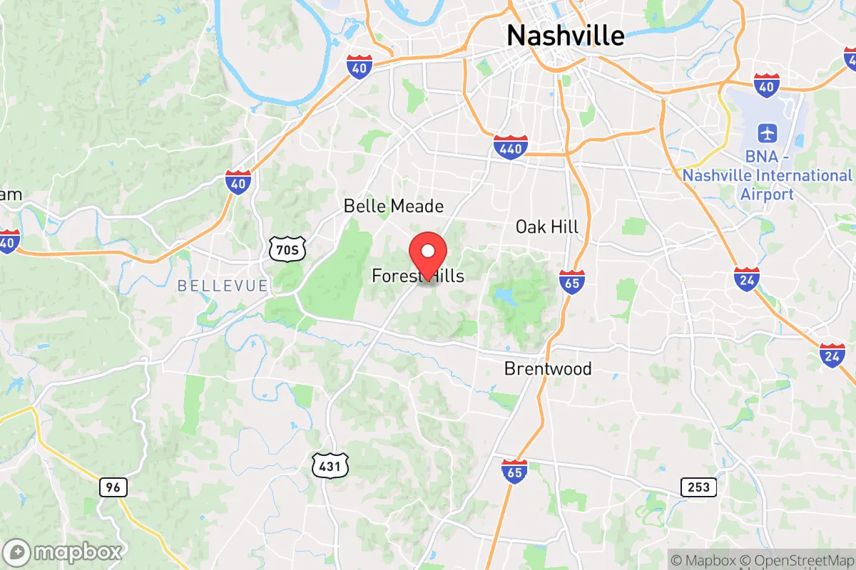
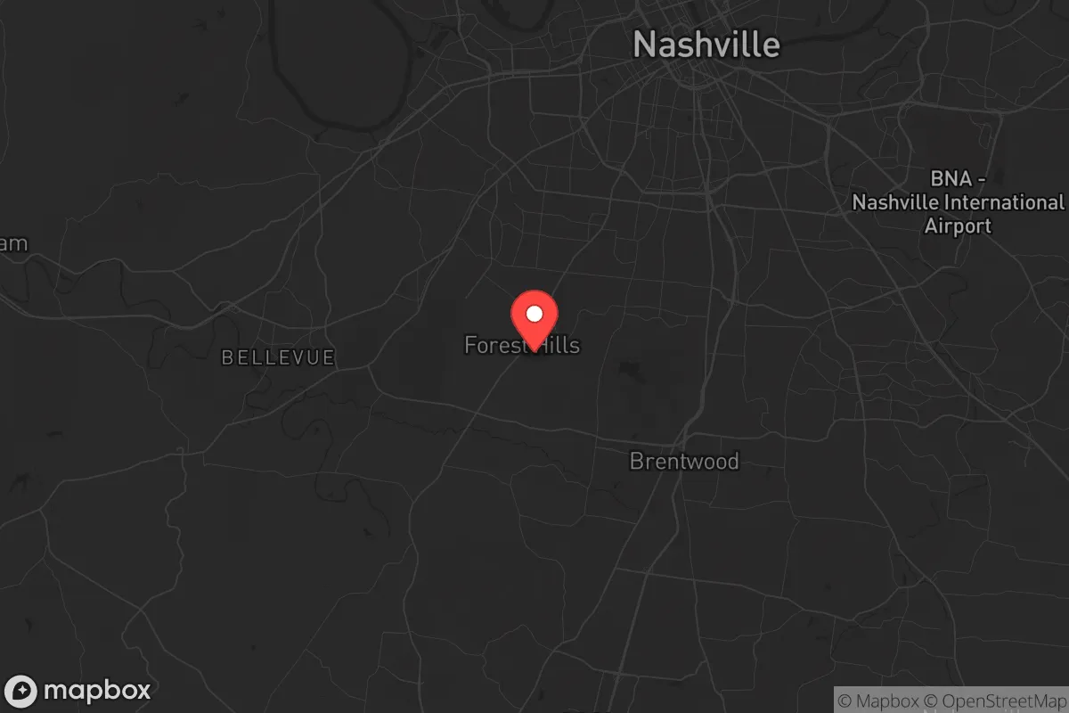
Strategic Assessment of Forest Hills, TN
Multiple tactical vulnerabilities. Population density, target proximity, or disaster risk are likely compounding. A retreat property and exit planning is required.
What does the Strategic Assessment tell us?
Our Strategic Assessment grades tactical survivability of an area. Major population centers, military targets, fallout zones, natural disasters, and border exposure all drive risk — lower exposure means a more defensible position in a crisis.
This is heavily inspired by Joel Skousen's Strategic Relocation book. Highly recommended you checkout the book ($)What does this tell us?
Our Strategic Assessment grades tactical survivability of an area. Major population centers, military targets, fallout zones, natural disasters, and border exposure all drive risk — lower exposure means a more defensible position in a crisis.
This is heavily inspired by Joel Skousen's Strategic Relocation book. Highly recommended you checkout the book ($)Strategic Pillars

Key Distances
Regional Safe Places
Below is our recommended "safe zones" in Tennessee and the surrounding area based on our strategic heuristics. For most people, it's unrealistic to live in a “safe zone” full-time due to work, family or other personal reasons. They tend to be more rural. However, many of these areas are perfect for second homes and retreat properties that double as a vacation home or even a short-term rental.
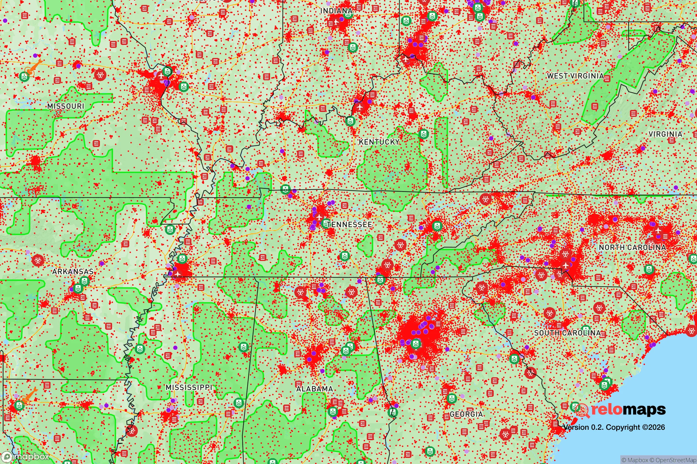
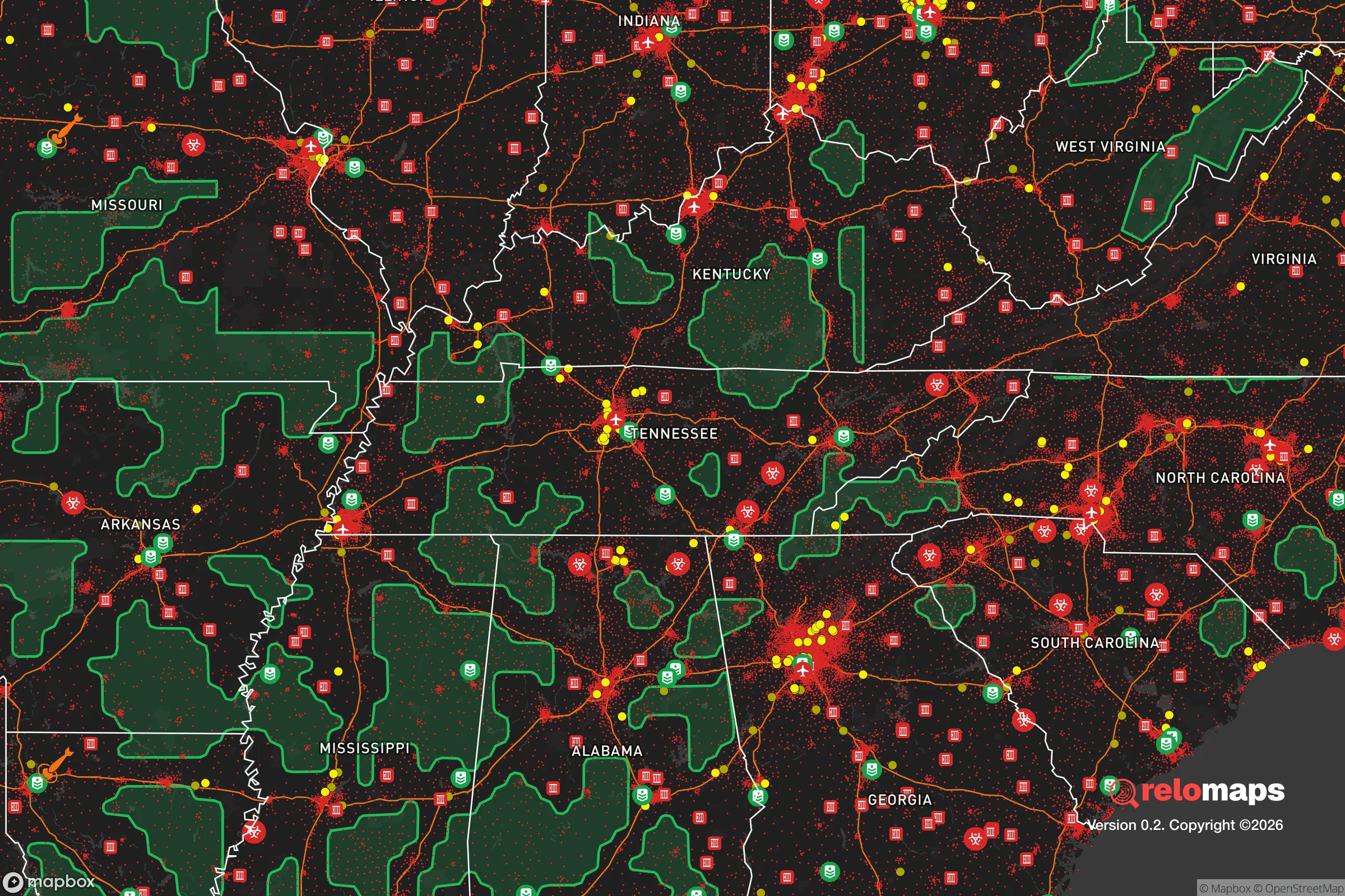
Important Note: For informational purposes only. This does not mean nothing bad ever happens in the green zones. Please use common sense. This is based on public data and modeled with AI. We tried to take a conservative approach but mistakes happen. We update this regularly as new information becomes available.
Solar Generator Recommendations
Backup power matters more here than in safer locations. We've picked three solar generators across budgets and capacity tiers — start with the budget unit if you only need a few essentials, or step up if you want to run a fridge and HVAC for days at a time.

Jackery Portable Power Station Explorer 300
Budget OptionPower on the Go: Weighing only 11 lbs, it's convenient to set up and store with book-sized foldable solar panels

BLUETTI Portable Power Station AC180
Designed for both indoor and outdoor scenarios, AC180 is highly capable as it has a robost capacity and continuous output power.

EF ECOFLOW DELTA Pro Ultra Power Station
Upgraded PickEcoFlow DELTA Pro Ultra is a whole-home energy system designed to grow with your family. Integrated with the Smart Home Panel 2, it scales to meet your evolving energy needs — keeping your home powered, intelligent, and secure through every stage of life.
We earn a commission, at no additional cost to you.
Strategic Assessment Analysis
Forest Hills, Tennessee, offers a strategic paradox for the conservative prepper: it sits in the immediate shadow of a major urban center (Nashville) yet provides a defensible, resource-rich pocket of relative isolation that many relocators overlook. The town’s resilience hinges on its ability to leverage proximity to critical infrastructure while maintaining a low profile—a balance that requires deliberate planning, not passive assumption. For the single individual or family prioritizing self-sufficiency and security, Forest Hills presents a viable base of operations, but only if you understand its specific vulnerabilities and advantages before you commit.
Geographic position and natural advantages for long-term security
Forest Hills occupies roughly 9 square miles of rolling, wooded terrain in Williamson County, about 8 miles southwest of downtown Nashville. Its elevation—averaging 750 to 850 feet above sea level—places it above the flood-prone Cumberland River basin, a meaningful advantage in a region where flash flooding and riverine flooding are recurring hazards. The area’s dense hardwood canopy provides natural cover and noise dampening, which can be tactically useful for maintaining a low signature during periods of unrest. The underlying geology is primarily limestone and shale, which supports stable foundations for underground shelters or root cellars, though digging can require specialized equipment. Water access is a standout feature: the Little Harpeth River runs along the town’s western edge, and numerous springs and seeps are scattered through the deeper ravines. While these sources are not potable without treatment, they offer a reliable backup for irrigation and hygiene if municipal supply is disrupted. The surrounding Williamson County countryside—still largely agricultural to the south and west—provides a buffer zone of open land that slows any urban spillover, giving residents precious hours of warning if evacuation becomes necessary.
Risks, exposures, and proximity to fallout-relevant landmarks
The single greatest vulnerability for Forest Hills is its proximity to Nashville’s critical infrastructure and population density. The town lies within 12 miles of the Nashville International Airport (BNA), a major logistics hub and potential target for both conventional and asymmetric threats. The CSX rail line running through nearby Antioch carries hazardous materials, including chlorine and ammonia, through a corridor that passes within 5 miles of Forest Hills’ eastern edge. A derailment or deliberate release could contaminate air and water supplies for days. The Tennessee Valley Authority’s Cumberland Fossil Plant, about 30 miles northwest, stores coal ash ponds that have a history of structural concerns; a catastrophic failure could send toxic slurry down the Cumberland River system, affecting groundwater recharge zones. On the human threat side, Nashville’s population of roughly 700,000 (metro area over 2 million) means that any large-scale civic unrest—whether from economic collapse, election disputes, or supply chain disruptions—could push tens of thousands of people outward along the primary evacuation routes (I-40, I-65, and Highway 100). Forest Hills sits directly on Highway 100, a major arterial that would become a choke point. The town’s single primary road network (Belle Meade Boulevard, Harding Place) offers limited egress options; a determined crowd or roadblock could effectively trap residents. For the prepper, this means that defensible retreat is viable only if you have a secondary exit plan—a backcountry route via the Warner Parks trail system or a pre-positioned vehicle on a private easement.
Practical resilience for a relocator: food, water, energy, and defensibility
Forest Hills’ practical resilience is a mixed bag that rewards proactive investment. Water security is the strongest asset: the Little Harpeth River flows year-round, and the average annual rainfall of 50 inches means rainwater catchment is highly productive. A 1,000-square-foot roof can collect roughly 30,000 gallons per year—enough for a family of four with careful use. The local water table sits at 20-40 feet in most areas, making a driven well feasible for those with drilling rights. However, municipal water comes from the Harpeth Valley Utility District, which draws from the Cumberland River; a contamination event upstream (e.g., from the coal ash ponds or a chemical spill) would cut off treated supply for weeks. Energy independence is achievable but requires upfront capital: the area averages 215 sunny days per year, sufficient for a 10-12 kW solar array with battery storage to cover baseline loads. Natural gas is piped through the Piedmont system, which is moderately reliable but vulnerable to cyberattack or physical sabotage. Wood heating is practical given the forest cover, but air quality regulations in Williamson County limit outdoor burning during inversion events. Food production is limited by lot size: most Forest Hills properties are 1-5 acres, enough for a substantial garden, a small orchard, and a few chickens or goats, but not for full caloric self-sufficiency. The nearby Franklin Farmers Market (10 miles south) and local CSA networks provide a buffer, but these would collapse in a prolonged disruption. Defensibility is the weakest link: the town’s winding, tree-lined roads create natural ambush points for intruders, but they also limit your own fields of fire and observation. Most homes sit close to the road, with shallow setbacks and large windows—a security liability. Retrofitting with ballistic film, reinforced doors, and a perimeter sensor system is strongly recommended. The local police department (Forest Hills Police Department) has about 10 officers and a response time of 5-10 minutes for priority calls; in a widespread event, that drops to zero. Community resilience is a wild card: Williamson County skews heavily conservative (Trump won 62% in 2020), and many neighbors are likely armed and sympathetic to self-reliance. But the town’s affluence means that some residents may be unprepared for hard times, potentially becoming a liability if they panic or attempt to flee through your property.
The overall strategic picture for Forest Hills is that of a high-potential but high-maintenance relocation target. It offers genuine natural advantages—water, cover, elevation, and a politically aligned community—that make it a credible base for a prepared individual or family. But those advantages are contingent on active mitigation of its core weaknesses: limited egress, proximity to Nashville’s target-rich environment, and a housing stock designed for comfort, not defense. If you are willing to invest in off-grid water and power, harden your home against intrusion, and establish a secondary evacuation route through the Warner Parks or private land to the south, Forest Hills can serve as a sustainable redoubt for the next decade of uncertainty. If you expect to simply move in and ride out the storm without preparation, the town’s proximity to a major city will become a liability rather than an asset. The conservative prepper’s calculus here is clear: Forest Hills is not a bug-out location—it is a live-in position that demands constant readiness.
* Values derived from national, state, county, city and local statistics and may differ in a specific area. Last updated: 2026-04-27T15:26:24.000Z
Narrative content on this page is AI-generated and may contain mistakes. Verify any details that matter before acting on them.
ReloMaps may earn a commission from affiliate links at no extra cost to you.