Photo: Wikipedia
Strategic Assessment of Glendale, CA
High tactical risk. This location is likely close to major population centers, strategic targets, or sits in a high-disaster corridor. A retreat property and careful exit planning is required.
What does the Strategic Assessment tell us?
Our Strategic Assessment grades tactical survivability of an area. Major population centers, military targets, fallout zones, natural disasters, and border exposure all drive risk — lower exposure means a more defensible position in a crisis.
This is heavily inspired by Joel Skousen's Strategic Relocation book. Highly recommended you checkout the book ($)What does this tell us?
Our Strategic Assessment grades tactical survivability of an area. Major population centers, military targets, fallout zones, natural disasters, and border exposure all drive risk — lower exposure means a more defensible position in a crisis.
This is heavily inspired by Joel Skousen's Strategic Relocation book. Highly recommended you checkout the book ($)Strategic Pillars

Key Distances
Regional Safe Places
Below is our recommended "safe zones" in California and the surrounding area based on our strategic heuristics. For most people, it's unrealistic to live in a “safe zone” full-time due to work, family or other personal reasons. They tend to be more rural. However, many of these areas are perfect for second homes and retreat properties that double as a vacation home or even a short-term rental.


Important Note: For informational purposes only. This does not mean nothing bad ever happens in the green zones. Please use common sense. This is based on public data and modeled with AI. We tried to take a conservative approach but mistakes happen. We update this regularly as new information becomes available.
Solar Generator Recommendations
Backup power matters more here than in safer locations. We've picked three solar generators across budgets and capacity tiers — start with the budget unit if you only need a few essentials, or step up if you want to run a fridge and HVAC for days at a time.

Jackery Portable Power Station Explorer 300
Budget OptionPower on the Go: Weighing only 11 lbs, it's convenient to set up and store with book-sized foldable solar panels

BLUETTI Portable Power Station AC180
Designed for both indoor and outdoor scenarios, AC180 is highly capable as it has a robost capacity and continuous output power.

EF ECOFLOW DELTA Pro Ultra Power Station
Upgraded PickEcoFlow DELTA Pro Ultra is a whole-home energy system designed to grow with your family. Integrated with the Smart Home Panel 2, it scales to meet your evolving energy needs — keeping your home powered, intelligent, and secure through every stage of life.
We earn a commission, at no additional cost to you.
Strategic Assessment Analysis
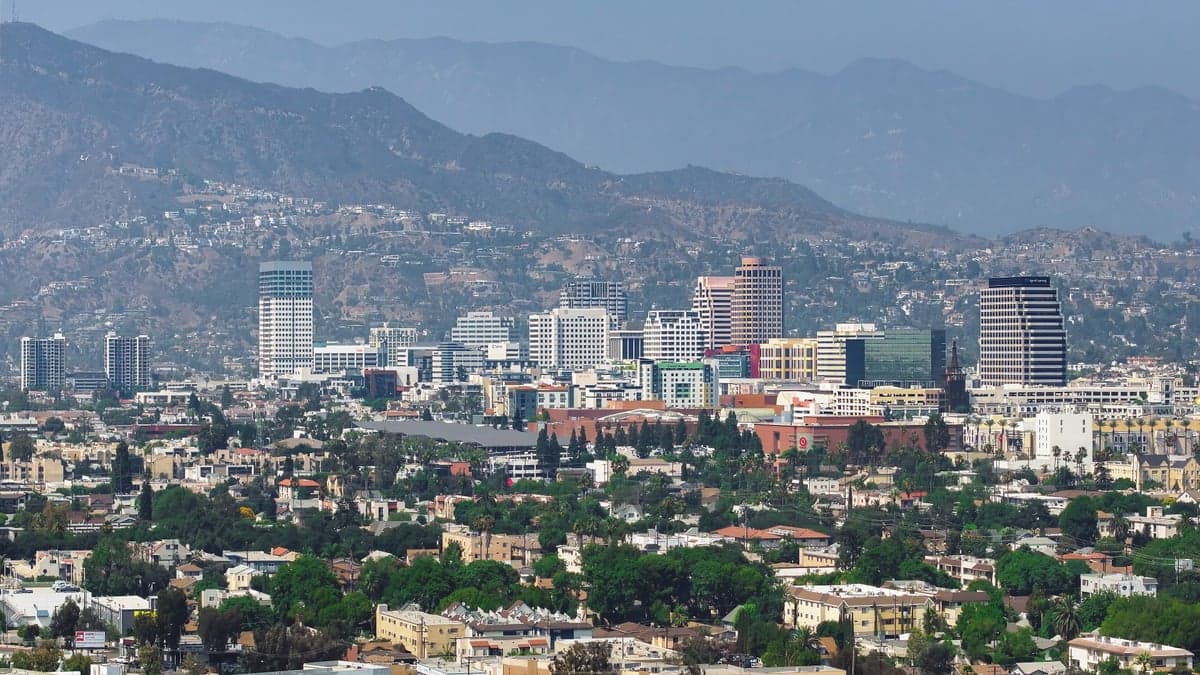
Glendale, California, presents a complex strategic picture for the conservative prepper. Its immediate advantages—proximity to the Angeles National Forest, a robust local water supply, and a geography that offers natural choke points—are undercut by its position as a dense, politically liberal suburb of Los Angeles. For a relocator prioritizing resilience against civic unrest, mass casualty events, and large-scale disasters, Glendale is a mixed bag: it offers some genuine survival assets, but its location and demographics introduce significant liabilities that cannot be ignored.
Geographic position and natural defensive advantages
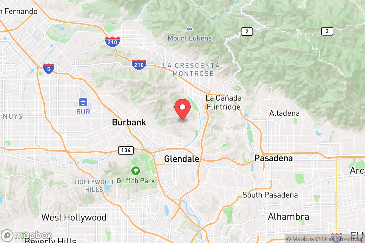
Glendale sits at the eastern edge of the San Fernando Valley, tucked against the Verdugo Mountains and the San Rafael Hills. This placement gives it a rare defensive asset: natural terrain that funnels traffic through a handful of key corridors. The 2 Freeway, the 134 Freeway, and the 5 Freeway are the primary arteries, and in a crisis, these can be monitored or blocked far more easily than the sprawling grid of central Los Angeles. The Verdugos and the San Gabriels to the north provide a literal wall, limiting approach vectors and offering potential retreat routes into the Angeles National Forest. For a prepper, this means Glendale is more defensible than the flat, open basins of the LA metro area. The city also sits atop a significant groundwater basin—the San Fernando Basin—which, while shared with other municipalities, gives Glendale a better water security profile than cities reliant entirely on the State Water Project. The local climate, with low humidity and moderate temperatures, reduces the risk of heat-related infrastructure failures compared to desert or inland locations.
Risks, exposures, and proximity to fallout-relevant landmarks
The liabilities are substantial and cannot be glossed over. Glendale is less than 10 miles from downtown Los Angeles, a primary target for any large-scale civil unrest or mass casualty event. The city is also adjacent to Burbank, home to Bob Hope Airport and major media studios—both potential flashpoints or secondary targets. The 5 Freeway corridor is a known chokepoint that, in a crisis, would become a parking lot, trapping evacuees. Furthermore, Glendale is within the blast radius and fallout zone of several potential targets: the Port of Los Angeles/Long Beach (a major strategic asset), the Los Angeles International Airport, and the region's electrical grid nodes. Wildfire risk is acute, especially in the northern neighborhoods abutting the Angeles National Forest. The 2019 Tick Fire and the 2020 Station Fire are reminders that Glendale's natural defenses can become liabilities when fire sweeps down from the mountains. Earthquake risk is also high—the San Andreas Fault is roughly 40 miles north, and the local thrust faults (like the Sierra Madre) could produce a magnitude 7.0 event that would sever roads, water lines, and power for weeks. For the prepper, the proximity to these hazards means that Glendale is not a bug-out location; it is a location that may require bugging out.
Practical resilience for a relocator: food, water, energy, and defensibility
On the practical side, Glendale has some genuine resilience assets. The city operates its own water and power utility, Glendale Water & Power (GWP), which gives it more control than cities reliant on LADWP or SCE. GWP has a diverse energy portfolio including hydro, solar, and natural gas, and it maintains a local emergency operations center. The city's water system draws from local wells in the San Fernando Basin, reducing dependence on the California Aqueduct, which is vulnerable to earthquake disruption. For food security, Glendale has a high density of grocery stores, including multiple ethnic markets (Armenian, Middle Eastern, Asian) that offer bulk staples. However, local agricultural production is virtually zero—the city is fully built out, and community gardens are small and contested. For a relocator, this means a pre-existing food stockpile is essential, not optional. Defensibility at the neighborhood level varies. The hillside areas (e.g., Glenoaks Canyon, Chevy Chase Canyon) offer natural isolation and limited access, but they are also high-risk for wildfire and have narrow, winding roads that can be blocked by a single accident. The flat, grid-based neighborhoods south of the 134 Freeway are more vulnerable to civil unrest due to easy access from the freeway and proximity to LA. Community cohesion is a wildcard. Glendale has a large Armenian-American population (roughly 40%), which has historically been tight-knit and self-reliant. This can be a resilience asset—neighborhood watch groups, mutual aid networks, and cultural institutions that function independently of city government. However, it can also create social friction with other groups, which could be a liability during a breakdown of order. For the conservative prepper, the key question is whether you can integrate into that existing network or whether you will remain an outsider.
The overall strategic picture for Glendale is one of calculated risk. It offers genuine geographic advantages—natural barriers, a local water supply, and a municipal utility with some independence—that are rare in the LA basin. For a relocator who is willing to invest in a defensible hillside property, maintain a robust food and water cache, and build relationships within the existing community, Glendale could serve as a viable base of operations. But the downsides are real: proximity to a major target zone, acute wildfire and earthquake hazards, and a political environment that is overwhelmingly liberal and likely to be hostile to prepper activities. Glendale is not a retreat; it is a forward operating base—a place to live and work while maintaining the ability to evacuate to a more secure location (e.g., the high desert or the Sierra foothills) when the situation deteriorates. For the single individual or family who wants to stay connected to the economic opportunities of Southern California while maintaining a survivalist posture, Glendale is a plausible, if imperfect, choice. For those seeking a true redoubt, look further north or east.
* Values derived from national, state, county, city and local statistics and may differ in a specific area. Last updated: 2026-04-24T19:34:03.000Z
Narrative content on this page is AI-generated and may contain mistakes. Verify any details that matter before acting on them.
ReloMaps may earn a commission from affiliate links at no extra cost to you.