 Popular
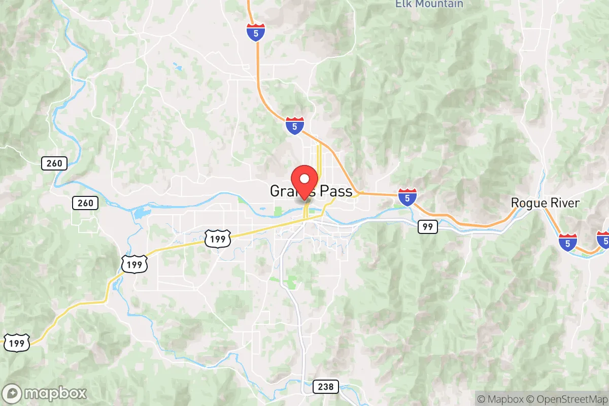
Photo: Wikipedia
Strategic Assessment of Grants Pass, OR
Workable tactical position. Some exposure to population density or targets, but generally defensible in a crisis.
What does the Strategic Assessment tell us?
Our Strategic Assessment grades tactical survivability of an area. Major population centers, military targets, fallout zones, natural disasters, and border exposure all drive risk — lower exposure means a more defensible position in a crisis.
This is heavily inspired by Joel Skousen's Strategic Relocation book. Highly recommended you checkout the book ($)What does this tell us?
Our Strategic Assessment grades tactical survivability of an area. Major population centers, military targets, fallout zones, natural disasters, and border exposure all drive risk — lower exposure means a more defensible position in a crisis.
This is heavily inspired by Joel Skousen's Strategic Relocation book. Highly recommended you checkout the book ($)Strategic Pillars

Key Distances
Regional Safe Places
Below is our recommended "safe zones" in Oregon and the surrounding area based on our strategic heuristics. For most people, it's unrealistic to live in a “safe zone” full-time due to work, family or other personal reasons. They tend to be more rural. However, many of these areas are perfect for second homes and retreat properties that double as a vacation home or even a short-term rental.


Important Note: For informational purposes only. This does not mean nothing bad ever happens in the green zones. Please use common sense. This is based on public data and modeled with AI. We tried to take a conservative approach but mistakes happen. We update this regularly as new information becomes available.
Solar Generator Recommendations
Backup power matters more here than in safer locations. We've picked three solar generators across budgets and capacity tiers — start with the budget unit if you only need a few essentials, or step up if you want to run a fridge and HVAC for days at a time.

Jackery Portable Power Station Explorer 300
Budget OptionPower on the Go: Weighing only 11 lbs, it's convenient to set up and store with book-sized foldable solar panels

BLUETTI Portable Power Station AC180
Designed for both indoor and outdoor scenarios, AC180 is highly capable as it has a robost capacity and continuous output power.

EF ECOFLOW DELTA Pro Ultra Power Station
Upgraded PickEcoFlow DELTA Pro Ultra is a whole-home energy system designed to grow with your family. Integrated with the Smart Home Panel 2, it scales to meet your evolving energy needs — keeping your home powered, intelligent, and secure through every stage of life.
We earn a commission, at no additional cost to you.
Strategic Assessment Analysis
Grants Pass, Oregon, sits in a geographic sweet spot that combines genuine strategic depth with the kind of everyday livability that makes long-term resilience sustainable. Nestled in the Rogue Valley along the I-5 corridor, this town of roughly 40,000 offers a rare balance: it’s far enough from major metropolitan chaos to avoid the worst of civic unrest, yet close enough to critical infrastructure to keep supply chains and medical access viable. For a relocator thinking in decades rather than months, Grants Pass presents a defensible base with natural barriers, a working agricultural economy, and a community culture that still values self-reliance. The key is understanding where its strengths end and its vulnerabilities begin.
Geographic position and natural advantages for long-term security
Grants Pass occupies a valley floor at the confluence of the Rogue and Applegate Rivers, ringed by the Siskiyou and Cascade mountain ranges. This topography provides natural chokepoints and observation advantages. The surrounding national forests—Siskiyou, Rogue River-Siskiyou, and Umpqua—offer vast buffer zones that make large-scale population movement difficult without prior reconnaissance. The area’s elevation (roughly 950 feet) keeps it above the worst valley inversions that plague Medford to the east, while the rivers provide reliable surface water even in drought years. For a prepper, the key metric is distance to major population centers: Grants Pass sits 170 miles from Portland and 80 miles from the Eugene-Springfield metro, far enough to avoid the immediate fallout of urban unrest but close enough to access medical evacuation or supply runs if roads remain open. The Rogue Valley International-Medford Airport (35 miles east) offers a secondary evacuation node, though its proximity to I-5 also makes it a potential target during collapse scenarios.
Risks, exposures, and proximity to fallout-relevant landmarks
No location is immune, and Grants Pass has specific vulnerabilities that a strategic relocator must weigh. The most immediate is wildfire risk: the 2020 Almeda Fire destroyed over 2,500 structures in nearby Talent and Phoenix, and the Rogue Valley’s dry summers create a persistent threat. Grants Pass itself has better defensible space than those communities—wider streets, more irrigated lots—but the surrounding forested hillsides are a tinderbox during red-flag conditions. Earthquake risk is moderate but real; the Cascadia subduction zone could produce a 9.0+ megathrust event, and while Grants Pass is inland enough to avoid tsunami inundation, the shaking would damage older housing stock and disrupt I-5 bridges. Fallout-relevant landmarks within a 100-mile radius include the Oregon Institute of Technology (a nuclear engineering program) and the Klamath Falls airport (a potential FEMA staging point), but no active nuclear power plants or major military installations. The nearest significant target is the Portland metro area, which houses critical infrastructure (Port of Portland, Intel’s Hillsboro campus, multiple rail yards) that could draw secondary effects like refugee flows or supply chain disruptions. The I-5 corridor itself is a double-edged sword: it enables resupply but also funnels displaced populations southward during a crisis.
Practical resilience for a relocator: food, water, energy, and defensibility
Grants Pass excels in the fundamentals of long-term self-sufficiency. The Rogue Valley is one of Oregon’s most productive agricultural regions, with over 200,000 acres of irrigated farmland producing pears, wine grapes, hay, and livestock. A relocator with a few acres can realistically achieve significant food independence within two growing seasons. Water access is above average: the Rogue River flows year-round, and groundwater tables in the valley are generally reliable, though well permits require due diligence (some areas have limited allocations). Energy resilience is mixed. The local utility, Pacific Power, draws from a mix of hydro, natural gas, and coal, but the grid is vulnerable to wildfire shutoffs and ice storms. Solar potential is excellent—Grants Pass averages 200+ sunny days per year—and off-grid systems are common enough that local installers and parts suppliers are available. Defensibility is where the area truly shines. The valley floor is open enough to provide fields of fire, but the surrounding hills offer natural redoubts. The community culture leans heavily toward preparedness: gun ownership is widespread, local shooting ranges are active, and the county sheriff’s office maintains a strong relationship with the public. The downside is that property crime rates are above the national average (roughly 40% higher for theft and burglary), meaning a relocator must harden their home and outbuildings. Rural properties without visible security measures are routinely targeted by transient populations moving along I-5.
The overall strategic picture for a conservative relocator
Grants Pass offers a compelling package for someone who wants to be prepared without living in a bunker. The natural barriers, agricultural base, and community ethos of self-reliance create a foundation that can weather most scenarios short of a complete societal collapse. The trade-offs are real: wildfire risk requires constant vigilance and a defensible-space plan, the I-5 corridor introduces refugee-flow vulnerability, and the property crime problem means you cannot be complacent about security. But compared to the Portland metro or even Medford, Grants Pass provides a better balance of isolation and access. For a family or single individual looking to build a resilient life in a region that still respects property rights and personal responsibility, this is one of the better options in the Pacific Northwest. The key is to buy with water access, invest in fire-hardening and solar, and get to know your neighbors—because in a real crisis, the people on your road will matter more than any stockpile.
* Values derived from national, state, county, city and local statistics and may differ in a specific area. Last updated: 2026-05-01T08:58:16.000Z
Narrative content on this page is AI-generated and may contain mistakes. Verify any details that matter before acting on them.
ReloMaps may earn a commission from affiliate links at no extra cost to you.