
Photo: Wikipedia
Strategic Assessment of Jacksonville, NC
Multiple tactical vulnerabilities. Population density, target proximity, or disaster risk are likely compounding. A retreat property and exit planning is required.
What does the Strategic Assessment tell us?
Our Strategic Assessment grades tactical survivability of an area. Major population centers, military targets, fallout zones, natural disasters, and border exposure all drive risk — lower exposure means a more defensible position in a crisis.
This is heavily inspired by Joel Skousen's Strategic Relocation book. Highly recommended you checkout the book ($)What does this tell us?
Our Strategic Assessment grades tactical survivability of an area. Major population centers, military targets, fallout zones, natural disasters, and border exposure all drive risk — lower exposure means a more defensible position in a crisis.
This is heavily inspired by Joel Skousen's Strategic Relocation book. Highly recommended you checkout the book ($)Strategic Pillars

Key Distances
Regional Safe Places
Below is our recommended "safe zones" in North Carolina and the surrounding area based on our strategic heuristics. For most people, it's unrealistic to live in a “safe zone” full-time due to work, family or other personal reasons. They tend to be more rural. However, many of these areas are perfect for second homes and retreat properties that double as a vacation home or even a short-term rental.


Important Note: For informational purposes only. This does not mean nothing bad ever happens in the green zones. Please use common sense. This is based on public data and modeled with AI. We tried to take a conservative approach but mistakes happen. We update this regularly as new information becomes available.
Solar Generator Recommendations
Backup power matters more here than in safer locations. We've picked three solar generators across budgets and capacity tiers — start with the budget unit if you only need a few essentials, or step up if you want to run a fridge and HVAC for days at a time.

Jackery Portable Power Station Explorer 300
Budget OptionPower on the Go: Weighing only 11 lbs, it's convenient to set up and store with book-sized foldable solar panels

BLUETTI Portable Power Station AC180
Designed for both indoor and outdoor scenarios, AC180 is highly capable as it has a robost capacity and continuous output power.

EF ECOFLOW DELTA Pro Ultra Power Station
Upgraded PickEcoFlow DELTA Pro Ultra is a whole-home energy system designed to grow with your family. Integrated with the Smart Home Panel 2, it scales to meet your evolving energy needs — keeping your home powered, intelligent, and secure through every stage of life.
We earn a commission, at no additional cost to you.
Strategic Assessment Analysis
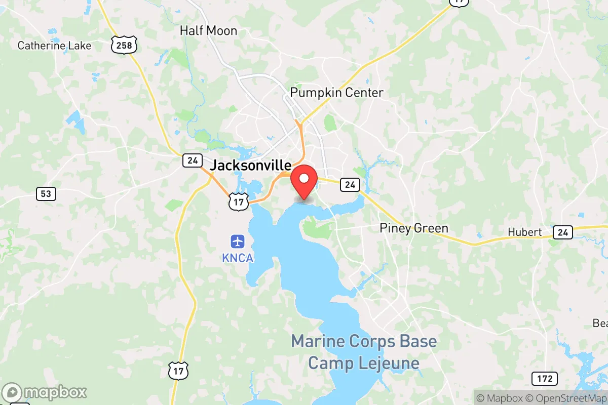
Jacksonville, North Carolina, offers a unique strategic position for those prioritizing resilience and preparedness, combining proximity to the Atlantic coast with the stabilizing presence of Marine Corps Base Camp Lejeune. This dual identity—a military town with a deep-rooted conservative culture and a coastal gateway—creates a relocation option that balances economic stability with a lower profile than major metropolitan areas. For single individuals and parents assessing long-term security, Jacksonville presents a compelling case as a location that is neither isolated from resources nor dangerously entangled in the vulnerabilities of sprawling urban centers.
Geographic position and natural advantages for long-term security
Jacksonville’s location in Onslow County places it roughly 50 miles north of Wilmington and 120 miles southeast of Raleigh, positioning it outside the immediate blast radius or fallout zones of any major city while still offering access to their infrastructure. The city sits along the New River, which provides a natural water source and a potential barrier against ground-level threats, though it is not a defensible chokepoint like a mountain pass. The surrounding landscape is a mix of coastal plain and pine forests, offering ample opportunities for rural retreats within a 30-minute drive—areas like Holly Ridge or Richlands provide lower population density and better concealment. The proximity to the Atlantic Ocean (about 15 miles from the coast at Topsail Beach) means access to maritime resources, but also introduces hurricane risk, which must be factored into any preparedness plan. The region’s temperate climate allows for year-round gardening and outdoor activities, a practical advantage for those focused on food security and self-sufficiency.
Risks, exposures, and proximity to fallout-relevant landmarks
The most significant risk factor for Jacksonville is its dependence on Camp Lejeune, a sprawling military installation that houses over 40,000 active-duty personnel and is a high-value target in any large-scale conflict or terrorist scenario. A conventional or asymmetric attack on the base could trigger immediate evacuation orders, martial law, or a lockdown of the surrounding area, potentially trapping residents in gridlock on the two main arteries—Highway 17 and Highway 24. Additionally, the nearby port of Morehead City, about 30 miles east, is a critical logistics hub for military and civilian shipping, making it another potential target for disruption. The city’s location along the Atlantic hurricane corridor means annual exposure to storm surges and flooding, particularly in low-lying areas near the New River and coastal communities. For the prepper mindset, these risks are manageable with proper planning—maintaining multiple evacuation routes, storing supplies for extended self-sufficiency, and avoiding flood-prone zones like the neighborhoods along Gum Branch Road or near the riverfront. The absence of nuclear power plants within a 50-mile radius (the nearest is Brunswick Nuclear Plant near Southport, about 60 miles southwest) reduces the risk of radiological fallout from an accident or attack, though the military base itself could be a secondary target for such threats.
Practical resilience for a relocator: food, water, energy, and defensibility
For a relocator focused on practical resilience, Jacksonville offers a mixed bag. The local water supply comes from the New River and groundwater wells, but municipal treatment plants are vulnerable to disruption; a well-installed property with a hand pump or solar-powered filtration system is a wise investment. The area’s agricultural potential is decent—the coastal plain supports crops like soybeans, corn, and sweet potatoes, and there are several farmers’ markets and local farms (e.g., the Onslow County Farmers’ Market) that can serve as supply sources during stable times. However, the soil is sandy and acidic, requiring amendments for serious gardening, so raised beds or hydroponics may be more reliable. Energy infrastructure is tied to the Duke Energy grid, which is prone to outages during hurricanes and storms; solar panels with battery storage are increasingly common among locals, and the region’s sunny climate (over 200 sunny days per year) makes this a viable option. Defensibility is a challenge in the city itself—the flat terrain and suburban sprawl offer little natural cover, and the high military presence means a significant number of armed residents, which could be a deterrent to looters but also a source of tension during civil unrest. For a more defensible setup, look to the rural areas west of Jacksonville, near the Croatan National Forest, where dense woods and limited road access provide better security. The local gun culture is strong, with several ranges and gun shops (e.g., Shooters’ Choice), and North Carolina’s permitless carry law (effective 2023) simplifies self-defense preparations. Stockpiling food and medicine is straightforward, with multiple big-box stores (Walmart, Lowe’s Foods) and a Costco in nearby Wilmington, but note that supply chains can be strained during hurricane season or national emergencies.
The overall strategic picture for Jacksonville is one of calculated trade-offs. It offers a robust community of like-minded individuals—many veterans and conservative families—who value preparedness and mutual aid, which is a significant social asset during crises. The military presence provides a steady economic base and a pool of skilled labor, but it also makes the area a potential flashpoint in a national emergency. For a single individual or parent seeking a location that balances access to coastal resources with a lower risk profile than cities like Raleigh or Charlotte, Jacksonville is a solid choice—provided you accept the hurricane risk and plan for the base’s influence. The key is to establish a home outside the immediate blast radius of Camp Lejeune, secure a reliable water source, and build a network with local prepper groups or church communities. In a world where urban centers are increasingly vulnerable to unrest and supply chain failures, Jacksonville stands as a middle-ground option: not a fortress, but a defensible outpost with a clear-eyed community that understands the value of being ready.
* Values derived from national, state, county, city and local statistics and may differ in a specific area. Last updated: 2026-05-03T20:24:53.000Z
Narrative content on this page is AI-generated and may contain mistakes. Verify any details that matter before acting on them.
ReloMaps may earn a commission from affiliate links at no extra cost to you.