Photo: Wikipedia
Strategic Assessment of Kaysville, UT
Workable tactical position. Some exposure to population density or targets, but generally defensible in a crisis.
What does the Strategic Assessment tell us?
Our Strategic Assessment grades tactical survivability of an area. Major population centers, military targets, fallout zones, natural disasters, and border exposure all drive risk — lower exposure means a more defensible position in a crisis.
This is heavily inspired by Joel Skousen's Strategic Relocation book. Highly recommended you checkout the book ($)What does this tell us?
Our Strategic Assessment grades tactical survivability of an area. Major population centers, military targets, fallout zones, natural disasters, and border exposure all drive risk — lower exposure means a more defensible position in a crisis.
This is heavily inspired by Joel Skousen's Strategic Relocation book. Highly recommended you checkout the book ($)Strategic Pillars

Key Distances
Regional Safe Places
Below is our recommended "safe zones" in Utah and the surrounding area based on our strategic heuristics. For most people, it's unrealistic to live in a “safe zone” full-time due to work, family or other personal reasons. They tend to be more rural. However, many of these areas are perfect for second homes and retreat properties that double as a vacation home or even a short-term rental.


Important Note: For informational purposes only. This does not mean nothing bad ever happens in the green zones. Please use common sense. This is based on public data and modeled with AI. We tried to take a conservative approach but mistakes happen. We update this regularly as new information becomes available.
Solar Generator Recommendations
Backup power matters more here than in safer locations. We've picked three solar generators across budgets and capacity tiers — start with the budget unit if you only need a few essentials, or step up if you want to run a fridge and HVAC for days at a time.

Jackery Portable Power Station Explorer 300
Budget OptionPower on the Go: Weighing only 11 lbs, it's convenient to set up and store with book-sized foldable solar panels

BLUETTI Portable Power Station AC180
Designed for both indoor and outdoor scenarios, AC180 is highly capable as it has a robost capacity and continuous output power.

EF ECOFLOW DELTA Pro Ultra Power Station
Upgraded PickEcoFlow DELTA Pro Ultra is a whole-home energy system designed to grow with your family. Integrated with the Smart Home Panel 2, it scales to meet your evolving energy needs — keeping your home powered, intelligent, and secure through every stage of life.
We earn a commission, at no additional cost to you.
Strategic Assessment Analysis
Kaysville, Utah, offers a compelling strategic position for those prioritizing resilience and preparedness, sitting in the shadow of the Wasatch Front but far enough from Salt Lake City’s core to provide a buffer against cascading urban failures. The city’s location at the mouth of Weber Canyon, with direct access to the Wasatch Mountains and the Great Basin, creates a natural chokepoint that can be leveraged for security while maintaining proximity to essential supply routes. For a relocator concerned with civic unrest, mass casualty events, or large-scale disasters, Kaysville’s blend of suburban infrastructure and mountain-adjacent geography provides a rare balance of accessibility and defensibility, though it is not without significant exposure risks that demand careful mitigation.
Geographic position and natural advantages for long-term survival
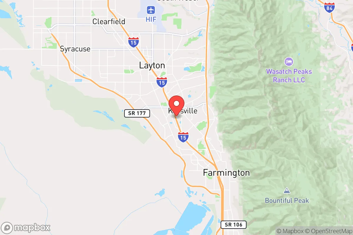
Kaysville sits at roughly 4,400 feet elevation in Davis County, nestled against the Wasatch Front with the Great Salt Lake to the west and the Uinta-Wasatch-Cache National Forest to the east. This positioning offers several strategic advantages. The city is roughly 25 miles north of Salt Lake City and 15 miles south of Ogden, placing it within a corridor that can be monitored and controlled if necessary. The nearby Wasatch Mountains provide a natural barrier against eastward threats and offer extensive wilderness for retreat, foraging, and water sourcing. The Weber River, which flows through the adjacent area, is a perennial water source that can be tapped for drinking and irrigation, though it requires treatment. The Great Salt Lake’s proximity means salt production and mineral extraction are possible, but its hypersaline water is not potable without desalination. The region’s arid climate—averaging 20 inches of precipitation annually—means water storage is critical, but the snowpack in the Wasatch provides a reliable seasonal melt that can be captured. For a prepper, the ability to retreat into the mountains within 30 minutes on foot is a significant asset, especially if the valley floor becomes compromised by civil unrest or contamination.
Risks, exposures, and proximity to fallout-relevant landmarks
Kaysville’s primary vulnerability stems from its location within the Wasatch Front, a densely populated corridor that includes Hill Air Force Base (HAFB) just 10 miles south, a major target in any conflict scenario. HAFB is a key logistics and maintenance hub for the U.S. Air Force, housing F-35 operations and nuclear-capable munitions storage. In a mass casualty event or war, this base would be a high-priority target for conventional or asymmetric attack, and Kaysville lies within the blast and fallout radius of a potential strike. Additionally, the city is 30 miles from the Salt Lake City International Airport and the central business district, which could become epicenters of civil unrest, disease outbreaks, or supply chain collapse. The I-15 corridor, which runs through Kaysville, is a double-edged sword: it provides evacuation routes but also funnels refugees and looters from the south. The nearby Wasatch Fault line poses a seismic risk—a major earthquake (7.0+ magnitude) could collapse infrastructure, disrupt water and power, and trigger landslides in the canyon. The city’s reliance on the Jordanelle and Deer Creek reservoirs for water means a prolonged drought or contamination event could cut supply. For a relocator, these risks demand a layered defense: a bug-out location in the mountains, a well-stocked basement or root cellar, and a plan to secure the home against both natural and human threats.
Practical resilience for a relocator: food, water, energy, and defensibility
Kaysville’s suburban layout—single-family homes on quarter-acre lots with basements—offers a solid foundation for self-sufficiency. Water is the most critical factor: the city’s municipal supply comes from the Weber Basin Project, but a prepper should install a 1,000-gallon rainwater catchment system and a Berkey or similar gravity filter for purification. The nearby Weber River and several small creeks (like Kays Creek) can supplement, but they require boiling or chemical treatment due to agricultural runoff. For food, the growing season is short (May to September) but productive for cold-hardy crops like potatoes, carrots, and kale. A greenhouse or cold frame extends the season, and the local soil is sandy loam that drains well. The city’s zoning allows for backyard chickens and small livestock, which is a plus for protein security. Energy resilience is moderate: the grid is reliable but vulnerable to earthquake or EMP. Solar panels with battery storage (e.g., Tesla Powerwall or DIY lithium setups) are viable given the 300+ sunny days per year, but winter snow cover reduces output. A backup propane generator with a 500-gallon tank is recommended for heating and cooking. Defensibility is Kaysville’s strongest suit: the city’s layout—grid streets with cul-de-sacs and limited entry points from the east (canyon roads)—makes it easier to monitor and control access. The local police department is well-funded, but in a collapse scenario, a neighborhood watch or mutual-aid group is essential. The nearby mountains offer multiple escape routes via trails and dirt roads, but these require pre-scouting and a vehicle with high clearance. For a single individual or family, Kaysville provides a manageable footprint for hardening: a reinforced basement, a perimeter fence, and a cache of supplies can create a defensible position.
The overall strategic picture for Kaysville is one of calculated risk. It is not a remote survivalist retreat—it is a suburban outpost on the edge of a major metropolitan area, with all the exposure that entails. But for a relocator who wants to maintain a semblance of normal life while preparing for the worst, it offers a rare combination of natural resources, defensible terrain, and access to wilderness. The key is to treat the city as a base camp, not a final redoubt. Stockpile for 90 days of isolation, establish a bug-out location in the Wasatch (e.g., near Francis or the Uinta Basin), and build relationships with like-minded neighbors. The Wasatch Front’s population density is a liability, but Kaysville’s position at the mouth of a canyon gives you an exit strategy that most suburbanites lack. If you can secure water, energy, and a plan to move east when the valley burns, this is a viable long-term position. If not, the risks from Hill AFB, the fault line, and the I-15 corridor will eventually catch up. Prepare accordingly.
* Values derived from national, state, county, city and local statistics and may differ in a specific area. Last updated: 2026-04-21T09:51:21.000Z
Narrative content on this page is AI-generated and may contain mistakes. Verify any details that matter before acting on them.
ReloMaps may earn a commission from affiliate links at no extra cost to you.