Photo: Wikipedia
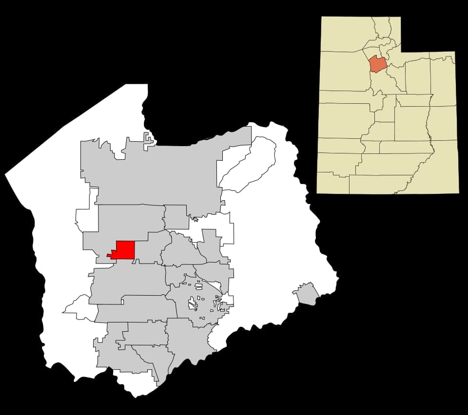
Strategic Assessment of Kearns, UT
Meaningful friction. Expect exposure to either population pressure, blast zones, or natural disaster risk. Consider buying a retreat property.
What does the Strategic Assessment tell us?
Our Strategic Assessment grades tactical survivability of an area. Major population centers, military targets, fallout zones, natural disasters, and border exposure all drive risk — lower exposure means a more defensible position in a crisis.
This is heavily inspired by Joel Skousen's Strategic Relocation book. Highly recommended you checkout the book ($)What does this tell us?
Our Strategic Assessment grades tactical survivability of an area. Major population centers, military targets, fallout zones, natural disasters, and border exposure all drive risk — lower exposure means a more defensible position in a crisis.
This is heavily inspired by Joel Skousen's Strategic Relocation book. Highly recommended you checkout the book ($)Strategic Pillars

Key Distances
Regional Safe Places
Below is our recommended "safe zones" in Utah and the surrounding area based on our strategic heuristics. For most people, it's unrealistic to live in a “safe zone” full-time due to work, family or other personal reasons. They tend to be more rural. However, many of these areas are perfect for second homes and retreat properties that double as a vacation home or even a short-term rental.


Important Note: For informational purposes only. This does not mean nothing bad ever happens in the green zones. Please use common sense. This is based on public data and modeled with AI. We tried to take a conservative approach but mistakes happen. We update this regularly as new information becomes available.
Solar Generator Recommendations
Backup power matters more here than in safer locations. We've picked three solar generators across budgets and capacity tiers — start with the budget unit if you only need a few essentials, or step up if you want to run a fridge and HVAC for days at a time.

Jackery Portable Power Station Explorer 300
Budget OptionPower on the Go: Weighing only 11 lbs, it's convenient to set up and store with book-sized foldable solar panels

BLUETTI Portable Power Station AC180
Designed for both indoor and outdoor scenarios, AC180 is highly capable as it has a robost capacity and continuous output power.

EF ECOFLOW DELTA Pro Ultra Power Station
Upgraded PickEcoFlow DELTA Pro Ultra is a whole-home energy system designed to grow with your family. Integrated with the Smart Home Panel 2, it scales to meet your evolving energy needs — keeping your home powered, intelligent, and secure through every stage of life.
We earn a commission, at no additional cost to you.
Strategic Assessment Analysis
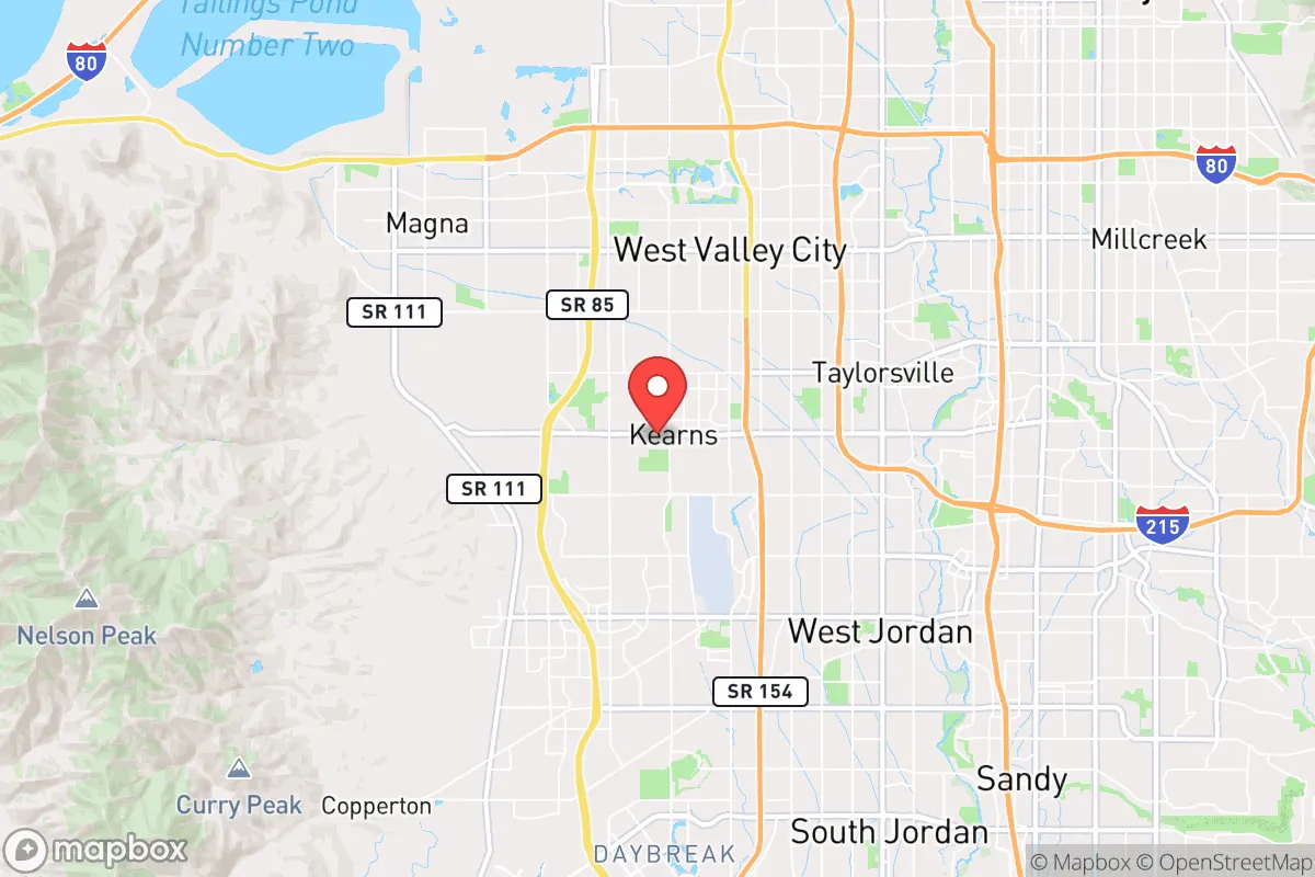
Kearns, Utah, sits in a precarious but potentially advantageous position for those prioritizing resilience and self-reliance. Located roughly 15 miles southwest of downtown Salt Lake City, this unincorporated township in Salt Lake County offers a suburban buffer that is close enough to access critical resources but far enough to avoid the immediate chaos of a major urban collapse. For a relocator with a survivalist mindset, the key question is whether this proximity to a major metropolitan area and its associated vulnerabilities—civil unrest, infrastructure strain, and fallout targets—outweighs the practical benefits of its geography and community layout. The answer is nuanced: Kearns provides a solid base for those who are prepared to be proactive, but it is not a remote redoubt.
Geographic position and natural advantages for long-term security
Kearns sits on the eastern edge of the Great Salt Lake Desert, with the Oquirrh Mountains rising to the west and the Wasatch Front to the east. This positioning offers a natural funnel effect: any large-scale movement of people or goods into or out of the Salt Lake Valley must pass through a limited number of choke points, such as the I-15 corridor or the mountain passes. For a prepared individual, this means you can monitor and potentially control access to your immediate area more easily than in a sprawling, flat region. The elevation—around 4,600 feet—provides a cooler, drier climate that reduces the risk of vector-borne diseases and mold-related issues common in humid zones. The nearby mountains also offer reliable watersheds; the Jordan River and its tributaries run through the valley, and while municipal water is treated, those with private wells or the ability to filter surface water have a distinct advantage. The Oquirrhs are not heavily forested, which limits wildfire risk compared to the Wasatch foothills, but they do provide cover and elevation for observation posts or retreats if needed.
Risks, exposures, and proximity to fallout-relevant landmarks
The most significant vulnerability for Kearns is its location within the Salt Lake Valley, which is a high-priority target zone in any major conflict. Hill Air Force Base, about 30 miles north, is a primary nuclear and conventional strike target. The Tooele Army Depot, roughly 25 miles west, stores chemical munitions and conventional explosives. The Salt Lake City International Airport, just 10 miles northeast, is a logistical hub that would be a secondary target. In a worst-case scenario, fallout from a strike on Hill AFB could drift southward, depending on prevailing winds, putting Kearns in a moderate-to-high risk zone. Additionally, the Wasatch Fault runs through the valley, and a major earthquake (magnitude 7.0 or greater) is a realistic threat. The soil in Kearns is largely alluvial and clay-based, which can liquefy during seismic events, damaging foundations and underground utilities. For a relocator, this means that any property should be evaluated for seismic retrofitting, and a bug-out location outside the valley—perhaps in the West Desert or the Uinta Basin—should be part of the plan. The concentration of population in the valley also makes Kearns a potential flashpoint for civil unrest; the 2020 protests in Salt Lake City demonstrated how quickly tensions can spill into suburban areas.
Practical resilience for a relocator: food, water, energy, and defensibility
Kearns is a mixed bag for practical self-sufficiency. Water is the most critical concern. The area receives only about 15 inches of precipitation annually, and the municipal supply is dependent on snowpack in the Wasatch and Uinta ranges. A multi-year drought or a contamination event (e.g., from a chemical spill or upstream industrial accident) could strain the system. A relocator should invest in a rainwater catchment system (though local regulations may limit this) and a deep well if the property allows. The soil is alkaline and rocky, making large-scale gardening challenging without raised beds and soil amendments, but a 1,000-square-foot garden can still produce a significant portion of a family's vegetables if managed intensively. For energy, the area has strong solar potential—over 200 sunny days per year—and net metering is available through Rocky Mountain Power, but a battery backup system is essential for grid-down scenarios. Natural gas is widely available, which is a plus for cooking and heating during outages. Defensibility is moderate: Kearns is a grid-pattern suburb with standard residential lots, meaning it lacks the natural barriers of a mountain retreat. However, the community is relatively tight-knit, with a strong sense of local identity (it was originally a planned community for defense workers during WWII). A prepared relocator can leverage neighborhood watch groups and local prepper networks, but should not rely on them. The proximity to I-15 and Bangerter Highway provides quick egress routes, but those same roads would be clogged during an evacuation. A secondary vehicle—a dirt bike or a 4x4 with off-road capability—is a smart investment for navigating backroads and the Oquirrh foothills.
The overall strategic picture for Kearns is one of calculated risk. It is not a remote survivalist paradise, nor is it a doomed urban trap. For a conservative-leaning individual or family who values community, access to resources, and the ability to maintain a low profile while preparing, Kearns offers a viable middle ground. The key is to treat it as a base of operations, not a final redoubt. Stockpile supplies for at least 90 days, develop a bug-out plan for the West Desert or the Uinta Basin, and invest in skills like water purification, first aid, and defensive shooting. The area's proximity to Hill AFB and the Wasatch Fault means you cannot afford complacency, but its location within a valley that has historically been a crossroads of trade and migration also means you have options. If you are willing to put in the work—both in preparation and in community building—Kearns can be a solid anchor in an uncertain world. Just don't expect it to save you if you ignore the fundamentals of self-reliance.
* Values derived from national, state, county, city and local statistics and may differ in a specific area. Last updated: 2026-05-09T23:45:00.000Z
Narrative content on this page is AI-generated and may contain mistakes. Verify any details that matter before acting on them.
ReloMaps may earn a commission from affiliate links at no extra cost to you.