
Photo: Wikipedia
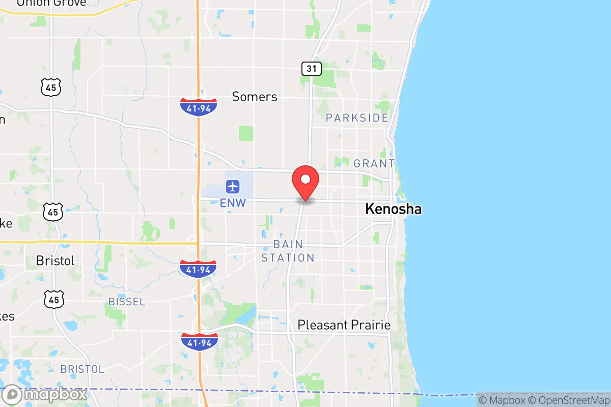
Strategic Assessment of Kenosha, WI
Multiple tactical vulnerabilities. Population density, target proximity, or disaster risk are likely compounding. A retreat property and exit planning is required.
What does the Strategic Assessment tell us?
Our Strategic Assessment grades tactical survivability of an area. Major population centers, military targets, fallout zones, natural disasters, and border exposure all drive risk — lower exposure means a more defensible position in a crisis.
This is heavily inspired by Joel Skousen's Strategic Relocation book. Highly recommended you checkout the book ($)What does this tell us?
Our Strategic Assessment grades tactical survivability of an area. Major population centers, military targets, fallout zones, natural disasters, and border exposure all drive risk — lower exposure means a more defensible position in a crisis.
This is heavily inspired by Joel Skousen's Strategic Relocation book. Highly recommended you checkout the book ($)Strategic Pillars

Key Distances
Regional Safe Places
Below is our recommended "safe zones" in Wisconsin and the surrounding area based on our strategic heuristics. For most people, it's unrealistic to live in a “safe zone” full-time due to work, family or other personal reasons. They tend to be more rural. However, many of these areas are perfect for second homes and retreat properties that double as a vacation home or even a short-term rental.
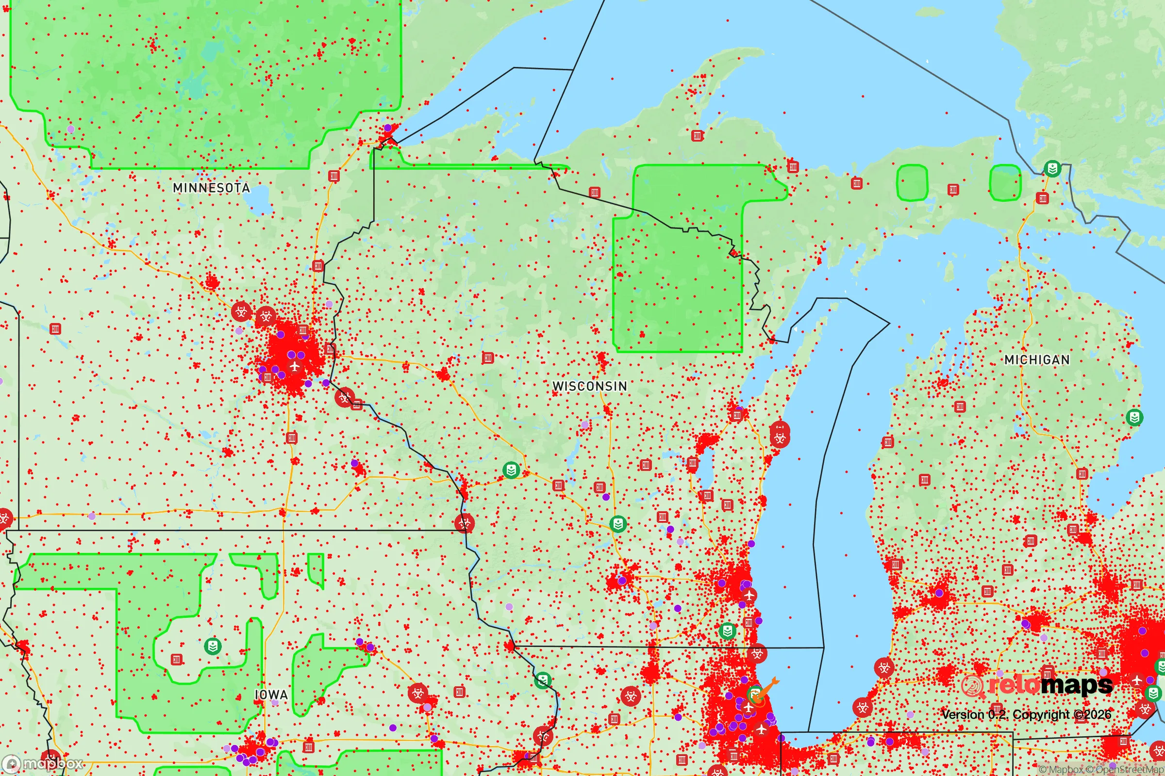
Important Note: For informational purposes only. This does not mean nothing bad ever happens in the green zones. Please use common sense. This is based on public data and modeled with AI. We tried to take a conservative approach but mistakes happen. We update this regularly as new information becomes available.
Solar Generator Recommendations
Backup power matters more here than in safer locations. We've picked three solar generators across budgets and capacity tiers — start with the budget unit if you only need a few essentials, or step up if you want to run a fridge and HVAC for days at a time.

Jackery Portable Power Station Explorer 300
Budget OptionPower on the Go: Weighing only 11 lbs, it's convenient to set up and store with book-sized foldable solar panels

BLUETTI Portable Power Station AC180
Designed for both indoor and outdoor scenarios, AC180 is highly capable as it has a robost capacity and continuous output power.

EF ECOFLOW DELTA Pro Ultra Power Station
Upgraded PickEcoFlow DELTA Pro Ultra is a whole-home energy system designed to grow with your family. Integrated with the Smart Home Panel 2, it scales to meet your evolving energy needs — keeping your home powered, intelligent, and secure through every stage of life.
We earn a commission, at no additional cost to you.
Strategic Assessment Analysis
Kenosha, Wisconsin, sits in a precarious strategic position that demands serious consideration for anyone prioritizing long-term resilience. Its location on the southwestern shore of Lake Michigan places it within a 60-mile drive of both Chicago and Milwaukee, offering access to major infrastructure while exposing it to the gravitational pull of those urban centers in a crisis. The city’s industrial past—home to the former Chrysler plant and a working port—gives it a blue-collar backbone, but its recent history of civil unrest in 2020 and ongoing demographic shifts make it a high-risk, high-reward proposition for a survival-minded relocator. For a conservative-leaning individual or family, the area offers genuine natural advantages in water and farmland, but those assets come with proximity to fallout zones that could turn a bad situation worse fast.
Geographic position and natural advantages for long-term survival
Kenosha’s primary strategic asset is its position on Lake Michigan, one of the largest freshwater bodies in the world. In a grid-down scenario or prolonged drought, access to that water—filtered or boiled—is a non-negotiable advantage over inland locations reliant on wells or municipal systems that may fail. The surrounding Kenosha County is part of the broader Southeastern Wisconsin glacial plain, with fertile loam soils that support row crops like corn and soybeans. A relocator with a few acres could realistically establish a garden or small farm within a 15-minute drive of the city center, particularly in areas like Somers or Bristol. The terrain is mostly flat to gently rolling, which simplifies construction and defensive positioning but offers little natural cover. Winters are cold and snowy, averaging 30–40 inches annually, which acts as a natural barrier to movement and can preserve stored food but also stresses heating fuel supplies. The proximity to Interstate 94 and the Union Pacific rail line provides logistical connectivity for trade or evacuation, but those same arteries become choke points during unrest or disaster.
Risks, exposures, and proximity to fallout-relevant landmarks
The most glaring vulnerability is Kenosha’s proximity to Chicago—roughly 40 miles south. In a mass casualty event, civil unrest, or economic collapse, Chicago’s population of 2.7 million would likely push north along I-94, turning Kenosha into a refugee bottleneck. The 2020 riots, which saw arson, looting, and the killing of two protesters, demonstrated how quickly tensions from the south can spill over. Kenosha is also within 30 miles of the Zion Nuclear Power Station (now decommissioned but still housing spent fuel) and within 100 miles of the Byron Nuclear Generating Station in Illinois. A radiological incident at either site could contaminate the lake and prevailing winds would carry fallout northeast, directly over the city. The Kenosha Regional Airport and the nearby Great Lakes Naval Base (40 miles north) are potential military targets or staging areas during a national emergency. Additionally, the city’s industrial corridor along the lakefront includes chemical storage and rail yards that could become secondary hazards in a disaster. For a prepper, these exposures mean that Kenosha is not a bug-out location—it’s a location that requires a plan to leave or harden in place.
Practical resilience for a relocator: food, water, energy, and defensibility
Water is the strongest card Kenosha plays. Lake Michigan provides an essentially unlimited supply, but accessing it requires either a shoreline property (expensive and vulnerable to lake-effect storms) or a municipal tap that depends on a functioning grid. A relocator should budget for a Berkey or similar gravity filter and at least 50 gallons of stored water per person for the first two weeks. Food resilience is moderate: the county has active farmers’ markets and U-pick operations (like Apple Barn Orchard in nearby Burlington), but grocery supply chains are heavily dependent on trucking from Chicago and Milwaukee. A 6-month pantry of shelf-stable goods is advisable, along with a chest freezer and a backup generator—natural gas outages are common during winter storms. Energy infrastructure is mixed. We Energies provides electricity via a grid that has seen aging transformer failures and storm-related outages lasting 24–48 hours. Solar potential is limited by cloud cover (roughly 180 sunny days per year), but a small propane generator or wood stove is practical. Defensibility is poor in the city itself—dense housing, multiple entry points, and a police force that was stretched thin during the 2020 unrest. Rural areas north and west of Kenosha, like the towns of Randall or Wheatland, offer better perimeter control with larger lots and fewer neighbors. The Kenosha County Sheriff’s Office has a reputation for professionalism, but response times in a widespread event would be measured in hours, not minutes.
Overall, Kenosha presents a mixed strategic picture for a conservative relocator with a prepper mindset. Its freshwater access and agricultural potential are genuine assets that few other Midwestern cities can match, and its industrial base means there are skilled tradespeople and hardware suppliers within reach. But the proximity to Chicago, the history of civil unrest, and the exposure to nuclear and industrial hazards make it a location that demands constant vigilance and a well-rehearsed evacuation plan. For a single individual or family willing to invest in a rural property 15–20 miles inland, with a reliable water source, a stocked pantry, and a community of like-minded neighbors, Kenosha County can work as a base of operations. For anyone expecting to ride out a major crisis within the city limits, the risks likely outweigh the rewards. Treat it as a staging ground, not a sanctuary, and you’ll be better positioned to adapt when the situation turns.
* Values derived from national, state, county, city and local statistics and may differ in a specific area. Last updated: 2026-04-21T10:14:14.000Z
Narrative content on this page is AI-generated and may contain mistakes. Verify any details that matter before acting on them.
ReloMaps may earn a commission from affiliate links at no extra cost to you.