Photo: Wikipedia
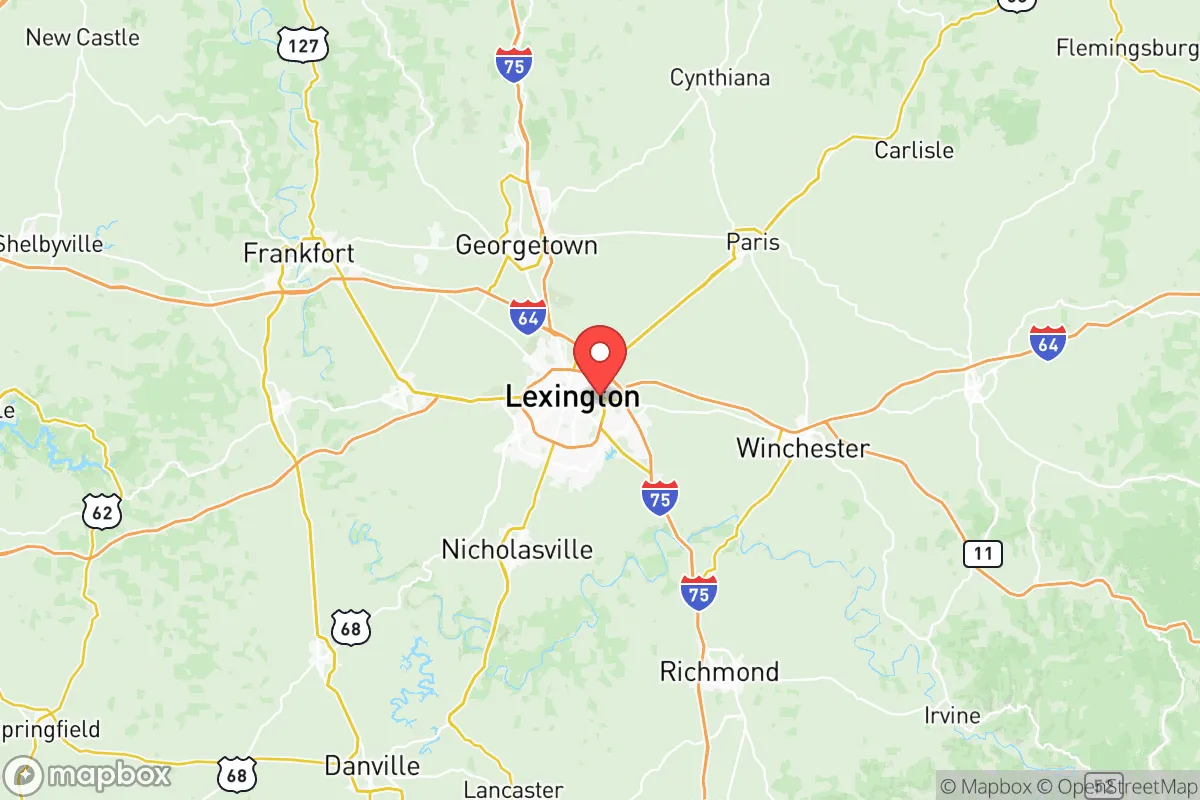
Strategic Assessment of Fayette County
Multiple tactical vulnerabilities. Population density, target proximity, or disaster risk are likely compounding. A retreat property and exit planning is required.
What does the Strategic Assessment tell us?
Our Strategic Assessment grades tactical survivability of an area. Major population centers, military targets, fallout zones, natural disasters, and border exposure all drive risk — lower exposure means a more defensible position in a crisis.
This is heavily inspired by Joel Skousen's Strategic Relocation book. Highly recommended you checkout the book ($)What does this tell us?
Our Strategic Assessment grades tactical survivability of an area. Major population centers, military targets, fallout zones, natural disasters, and border exposure all drive risk — lower exposure means a more defensible position in a crisis.
This is heavily inspired by Joel Skousen's Strategic Relocation book. Highly recommended you checkout the book ($)Strategic Pillars

Key Distances
Strategic Assessment Analysis
Fayette County, anchored by Lexington, offers a strategic blend of geographic insulation and regional access that appeals to those prioritizing long-term stability and self-reliance. Its position in the heart of the Bluegrass region places it roughly 75 miles from the Louisville metro area and 80 miles from Cincinnati, providing a buffer from the immediate fallout of urban unrest while still allowing for supply runs or medical access if needed. The area’s agricultural foundation, robust water resources, and distance from major industrial targets make it a credible option for relocators who want to be prepared for civic disruption without retreating to a remote bunker.
Geographic position and natural advantages for long-term stability
Fayette County sits on the Lexington Plain, a region of rolling limestone terrain that naturally filters water and supports some of the most fertile soil in the eastern United States. The Kentucky River forms the county’s western boundary, with the Palisades—steep limestone cliffs—providing a natural defensive barrier along parts of that corridor. The area is far enough from the Ohio River’s industrial corridor (Louisville’s chemical plants and the Rubbertown area are about 70 miles west) to reduce exposure to airborne contaminants from a potential industrial accident or attack. The county’s elevation averages around 950 feet, which mitigates flood risks common in lower-lying parts of the state. For a relocator, this means a lower probability of natural disaster displacement and a higher likelihood of maintaining access to clean groundwater and productive land. The proximity to the Bluegrass Army Depot in nearby Madison County (about 20 miles south) is a double-edged sword—it’s a potential target, but it also means a military presence and logistical infrastructure that could aid in post-disaster recovery.
Risks, exposures, and proximity to fallout-relevant landmarks
The primary strategic concern for Fayette County is its relative proximity to several high-value targets that could attract attention during a major conflict or terrorist event. The Bluegrass Army Depot stores chemical weapons and conventional munitions, and while it’s a secure facility, its existence makes the region a potential secondary target. Additionally, the county lies within 100 miles of the Fort Knox gold depository and the Paducah Gaseous Diffusion Plant (a former uranium enrichment site), both of which are high on any adversary’s target list. The Louisville International Airport and the UPS Worldport hub are about 70 miles west—a major logistics node that could be a choke point during a supply chain disruption. On the positive side, Fayette County itself has no major refineries, nuclear power plants, or large-scale chemical facilities, which reduces the risk of a local industrial catastrophe. The county’s population density (roughly 1,100 people per square mile in the urban core, dropping to under 200 in rural areas) means that a mass casualty event in Lexington would not reach the scale of a Houston or Chicago. For a relocator, the key is to settle in the county’s outer edges—places like Brannon Woods or Keene—to maximize distance from the urban center while still having access to its resources.
Practical resilience for a relocator: food, water, energy, and defensibility
Fayette County’s agricultural base is a major asset for anyone serious about self-sufficiency. The region is the heart of Kentucky’s horse and cattle industry, but it also supports row crops like corn, soybeans, and tobacco. Local farmers’ markets and CSAs are abundant, and the county has a strong network of small-scale producers who could be bartered with during a breakdown. Water is less of a concern here than in many parts of the country: the Kentucky River provides a reliable surface water source, and the limestone aquifer beneath the county yields high-quality groundwater at depths of 50 to 150 feet. For those drilling a well, the cost is moderate compared to arid regions. Energy infrastructure is mixed—Lexington is served by Kentucky Utilities, which relies heavily on coal and natural gas, but the county has seen a push toward solar in recent years. The E.W. Brown Generating Station (about 30 miles south in Mercer County) is a coal and natural gas plant that could be a target, but its distance reduces the immediate risk. Defensibility is where Fayette County shines compared to flatter, more open terrain. The limestone cliffs along the Kentucky River Palisades create natural chokepoints, and the county’s network of rural roads—many of them narrow and winding—makes it harder for large groups to move quickly. The Lexington Blue Grass Airport could be a liability during a mass evacuation, but it also means the area has a potential airlift capability if the military or FEMA gets involved. For a relocator, the ideal setup is a property with a well, a solar array, and enough acreage to raise a few head of cattle or a large garden, located in the southern or western parts of the county where the terrain is most defensible.
The overall strategic picture for Fayette County is one of moderate risk with high potential reward for those who plan ahead. It’s not a remote survivalist paradise—you’re still within a day’s drive of several major cities and military targets—but it offers a realistic balance of resources, defensibility, and community infrastructure that most preppers overlook. The county’s conservative lean (Fayette County voted for Trump in 2024 by a narrow margin, but the surrounding rural counties are solidly red) means that local governance is likely to resist federal overreach during a crisis, and the strong agricultural economy provides a buffer against supply chain disruptions. If you’re looking for a place that’s close enough to civilization to be practical but far enough to avoid the worst of the fallout, Fayette County deserves a serious look—just make sure you’re on the right side of the Kentucky River when things go sideways.
* Values derived from national, state, county, city and local statistics and may differ in a specific area. Last updated: 2026-05-21T13:12:52.000Z
Narrative content on this page is AI-generated and may contain mistakes. Verify any details that matter before acting on them.
ReloMaps may earn a commission from affiliate links at no extra cost to you.