Photo: Wikipedia
Strategic Assessment of Klamath Falls, OR
Workable tactical position. Some exposure to population density or targets, but generally defensible in a crisis.
What does the Strategic Assessment tell us?
Our Strategic Assessment grades tactical survivability of an area. Major population centers, military targets, fallout zones, natural disasters, and border exposure all drive risk — lower exposure means a more defensible position in a crisis.
This is heavily inspired by Joel Skousen's Strategic Relocation book. Highly recommended you checkout the book ($)What does this tell us?
Our Strategic Assessment grades tactical survivability of an area. Major population centers, military targets, fallout zones, natural disasters, and border exposure all drive risk — lower exposure means a more defensible position in a crisis.
This is heavily inspired by Joel Skousen's Strategic Relocation book. Highly recommended you checkout the book ($)Strategic Pillars

Key Distances
Regional Safe Places
Below is our recommended "safe zones" in Oregon and the surrounding area based on our strategic heuristics. For most people, it's unrealistic to live in a “safe zone” full-time due to work, family or other personal reasons. They tend to be more rural. However, many of these areas are perfect for second homes and retreat properties that double as a vacation home or even a short-term rental.


Important Note: For informational purposes only. This does not mean nothing bad ever happens in the green zones. Please use common sense. This is based on public data and modeled with AI. We tried to take a conservative approach but mistakes happen. We update this regularly as new information becomes available.
Solar Generator Recommendations
Backup power matters more here than in safer locations. We've picked three solar generators across budgets and capacity tiers — start with the budget unit if you only need a few essentials, or step up if you want to run a fridge and HVAC for days at a time.

Jackery Portable Power Station Explorer 300
Budget OptionPower on the Go: Weighing only 11 lbs, it's convenient to set up and store with book-sized foldable solar panels

BLUETTI Portable Power Station AC180
Designed for both indoor and outdoor scenarios, AC180 is highly capable as it has a robost capacity and continuous output power.

EF ECOFLOW DELTA Pro Ultra Power Station
Upgraded PickEcoFlow DELTA Pro Ultra is a whole-home energy system designed to grow with your family. Integrated with the Smart Home Panel 2, it scales to meet your evolving energy needs — keeping your home powered, intelligent, and secure through every stage of life.
We earn a commission, at no additional cost to you.
Strategic Assessment Analysis
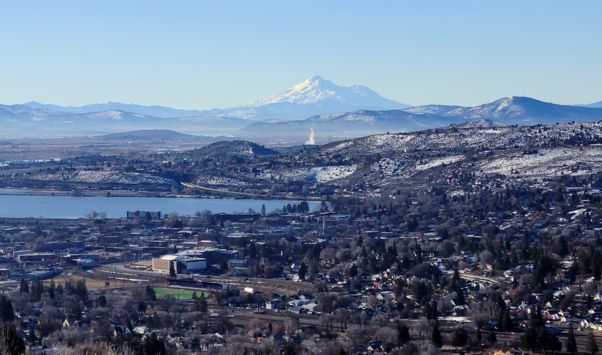
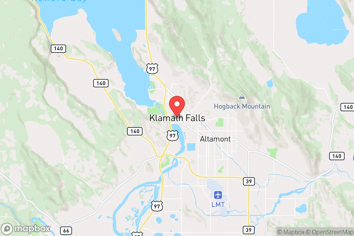
Klamath Falls offers a compelling strategic position for those prioritizing resilience and distance from major population centers, but it is not without significant trade-offs. Located in south-central Oregon near the California border, the city sits at the eastern edge of the Cascade Range, roughly 50 miles from the Oregon–California state line and over 250 miles from Portland, Seattle, or Sacramento. This isolation is a double-edged sword: it provides natural buffer from the cascading effects of urban collapse, but it also means limited immediate access to large-scale logistical support if things go sideways. The area’s high desert climate, abundant water resources from Upper Klamath Lake, and proximity to the Fremont-Winema National Forests create a baseline of natural advantages that few similarly sized towns can match. For a relocator thinking in terms of decades, not months, Klamath Falls checks several boxes—but only if you’re willing to work with its limitations.
Geographic position and natural advantages for long-term security
Klamath Falls sits at an elevation of roughly 4,100 feet, which gives it a four-season climate with cold winters and mild summers—a factor that naturally discourages transient populations and reduces the risk of heat-related infrastructure failures common in lower-elevation areas. The surrounding landscape is dominated by the Cascade Range to the west and the Basin and Range region to the east, creating a natural funnel that limits easy access from most directions. The city is served by U.S. Route 97 and Oregon Route 140, but neither is a major interstate, meaning traffic choke points are manageable and can be monitored or controlled with minimal effort. The Klamath River system, fed by Upper Klamath Lake, provides a reliable surface water source that is less contested than groundwater in the Central Valley or the Colorado River basin. The area also sits within the Klamath Basin, a region known for its geothermal activity—Klamath Falls itself has one of the highest concentrations of geothermal wells in the United States, used for heating homes and businesses. This energy independence is a serious advantage in a grid-down scenario, as geothermal systems can operate with minimal external fuel inputs. The nearby Fremont-Winema National Forests offer timber, game, and forage, though the forest is heavily managed and subject to federal restrictions that could become irrelevant in a crisis. For a prepper, the combination of water, geothermal energy, and defensible terrain makes this one of the more naturally fortified towns in the Pacific Northwest.
Risks, exposures, and proximity to fallout-relevant landmarks
The biggest strategic liability is Klamath Falls’ proximity to the Klamath Basin National Wildlife Refuges and the ongoing water rights conflicts that have defined the region for decades. The Klamath Project, a federal irrigation scheme, has been a flashpoint for disputes between farmers, tribes, and environmentalists, and any large-scale disruption to federal authority could trigger localized resource conflicts. More concerning is the city’s location relative to the Klamath Falls Airport (LMT), which hosts a U.S. Air Force radar site and is used for training by the Oregon Air National Guard. While not a primary nuclear target, any military installation becomes a potential secondary target in a major conflict, and the airport’s proximity to the city center (roughly 5 miles south) means fallout risk is non-trivial. Additionally, the city lies about 100 miles from the Oregon Coast, which is home to the Coos Bay Naval Facility and the Port of Coos Bay—both potential targets in a maritime conflict. The nearest major metropolitan area is Medford, about 70 miles west, which is large enough to generate refugee flows but not large enough to be a primary target itself. The real concern is the Cascade Range’s volcanic activity: Mount Mazama (Crater Lake) is about 60 miles northwest, and while an eruption is unlikely in any given year, the ashfall from even a moderate event could cripple the region’s air quality, water systems, and agriculture for months. For a relocator, the calculus is that Klamath Falls is far enough from high-value targets to avoid direct strikes but close enough to secondary infrastructure to warrant a solid fallout shelter and a multi-month supply of filtered air and water.
Practical resilience for a relocator: food, water, energy, and defensibility
Water is the strongest card Klamath Falls holds. Upper Klamath Lake holds over 1 million acre-feet of water, and the city’s municipal supply is drawn from it, with backup wells in the aquifer. For a homesteader, the lake and the Klamath River provide year-round surface water, though rights are heavily litigated—in a collapse scenario, that paperwork becomes irrelevant. The high desert climate means evaporation is moderate, and the growing season is short (roughly 100 frost-free days), but the volcanic soils in the surrounding valleys are fertile for potatoes, grains, and hardy vegetables. The area has a strong agricultural base, with hay, alfalfa, and cattle being the primary outputs, so local food production is viable if you secure land with water rights. Energy is where Klamath Falls truly shines: the city’s geothermal district heating system serves over 500 buildings, including schools and hospitals, and many homes have individual geothermal wells. Solar potential is good, with over 300 days of sunshine per year, though winter cloud cover can reduce output. The city is also near the Klamath River hydroelectric projects, including the J.C. Boyle Dam, which could be a target for sabotage but also a potential source of off-grid power if you’re positioned downstream. Defensibility is mixed: the city itself is relatively compact, with a population of about 22,000, and the surrounding terrain is open sagebrush and juniper, making it hard to approach unseen but also hard to defend without a perimeter. The best strategy is to secure a property on the outskirts, preferably near the lake or a tributary, with good sightlines and a reliable water source. The local population is predominantly conservative and rural, with a strong hunting and firearms culture, which means you’re unlikely to be the only one prepared—but it also means you need to establish trust early. The Klamath County Sheriff’s Office is well-regarded locally, but in a prolonged crisis, law enforcement will be stretched thin, so mutual aid networks are essential.
The overall strategic picture for Klamath Falls is that of a solid B-tier relocation option for the serious prepper. It offers genuine natural advantages—water, geothermal energy, defensible terrain, and distance from primary targets—that many towns in the Pacific Northwest lack. But it also carries real risks: water rights conflicts, volcanic ashfall potential, and proximity to secondary military infrastructure that could draw fallout. The climate is harsh by coastal standards, and the growing season is short, meaning you’ll need to stockpile or trade for food if you can’t produce enough. The community is politically aligned with conservative values, which reduces friction but also means you’re entering an area where many residents are already self-sufficient and may view newcomers with suspicion. If you’re looking for a place to ride out a decade of instability with a solid plan for water, energy, and defense, Klamath Falls deserves a serious look. Just don’t expect it to be easy—the same isolation that protects you also limits your options if things go wrong. Come prepared, build relationships early, and treat the land with respect, and this high desert outpost can be a viable long-term redoubt.
* Values derived from national, state, county, city and local statistics and may differ in a specific area. Last updated: 2026-04-20T23:05:01.000Z
Narrative content on this page is AI-generated and may contain mistakes. Verify any details that matter before acting on them.
ReloMaps may earn a commission from affiliate links at no extra cost to you.