Photo: Wikipedia
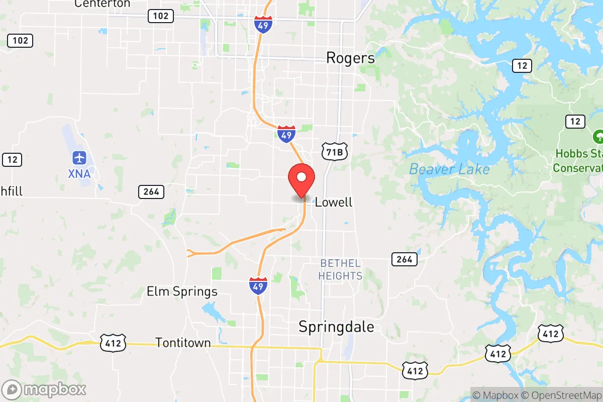
Strategic Assessment of Lowell, AR
Workable tactical position. Some exposure to population density or targets, but generally defensible in a crisis.
What does the Strategic Assessment tell us?
Our Strategic Assessment grades tactical survivability of an area. Major population centers, military targets, fallout zones, natural disasters, and border exposure all drive risk — lower exposure means a more defensible position in a crisis.
This is heavily inspired by Joel Skousen's Strategic Relocation book. Highly recommended you checkout the book ($)What does this tell us?
Our Strategic Assessment grades tactical survivability of an area. Major population centers, military targets, fallout zones, natural disasters, and border exposure all drive risk — lower exposure means a more defensible position in a crisis.
This is heavily inspired by Joel Skousen's Strategic Relocation book. Highly recommended you checkout the book ($)Strategic Pillars

Key Distances
Regional Safe Places
Below is our recommended "safe zones" in Arkansas and the surrounding area based on our strategic heuristics. For most people, it's unrealistic to live in a “safe zone” full-time due to work, family or other personal reasons. They tend to be more rural. However, many of these areas are perfect for second homes and retreat properties that double as a vacation home or even a short-term rental.


Important Note: For informational purposes only. This does not mean nothing bad ever happens in the green zones. Please use common sense. This is based on public data and modeled with AI. We tried to take a conservative approach but mistakes happen. We update this regularly as new information becomes available.
Solar Generator Recommendations
Backup power matters more here than in safer locations. We've picked three solar generators across budgets and capacity tiers — start with the budget unit if you only need a few essentials, or step up if you want to run a fridge and HVAC for days at a time.

Jackery Portable Power Station Explorer 300
Budget OptionPower on the Go: Weighing only 11 lbs, it's convenient to set up and store with book-sized foldable solar panels

BLUETTI Portable Power Station AC180
Designed for both indoor and outdoor scenarios, AC180 is highly capable as it has a robost capacity and continuous output power.

EF ECOFLOW DELTA Pro Ultra Power Station
Upgraded PickEcoFlow DELTA Pro Ultra is a whole-home energy system designed to grow with your family. Integrated with the Smart Home Panel 2, it scales to meet your evolving energy needs — keeping your home powered, intelligent, and secure through every stage of life.
We earn a commission, at no additional cost to you.
Strategic Assessment Analysis
Lowell, Arkansas, sits in a geographic sweet spot that offers genuine strategic depth for those thinking about long-term resilience, but it’s not without its own set of vulnerabilities. Located in the northwest corner of the state, this town of roughly 10,000 residents benefits from being part of the fast-growing Northwest Arkansas corridor while still maintaining a distinct small-town character. For a relocator with a prepper or survivalist mindset, the key question isn’t whether Lowell is perfect—it’s whether its advantages outweigh the risks inherent in being within striking distance of a major metro area like Fayetteville-Springdale-Rogers, which collectively push past 500,000 people. The answer is a cautious yes, provided you understand the trade-offs and plan accordingly.
Geographic position and natural advantages for long-term security
Lowell’s location in the Ozark foothills gives it a natural defensive layer that flatland communities simply don’t have. The terrain is rolling, wooded, and cut by creeks and rivers, which makes large-scale movement difficult and provides ample cover for those who know the land. The area sits at the intersection of two major highways—Interstate 49 and U.S. Highway 412—which is a double-edged sword: great for supply movement in a stable scenario, but a potential funnel for trouble during unrest. More importantly, Lowell is roughly 30 miles from the Oklahoma border and about 45 miles from Missouri, offering multiple escape vectors if the corridor becomes compromised. The region’s water resources are a standout: Beaver Lake, a massive U.S. Army Corps of Engineers reservoir, lies just 15 miles east, providing a reliable freshwater source that isn’t easily contaminated by urban runoff. The lake also supports a robust local fishing economy, which translates to a protein source that doesn’t depend on grocery store supply chains. For a relocator, the ability to tap into a 28,000-acre lake with year-round water access is a serious logistical advantage, especially when paired with the area’s relatively low population density outside the immediate highway corridors.
Risks, exposures, and proximity to fallout-relevant landmarks
Let’s be direct: Lowell’s biggest vulnerability is its proximity to the Northwest Arkansas metroplex. The town is essentially a bedroom community for Rogers and Bentonville, which means it’s within a 15-minute drive of Walmart’s global headquarters and the region’s major medical centers. In a mass casualty event or civil unrest scenario, that proximity becomes a liability. Bentonville’s Walmart headquarters alone employs over 16,000 people, and the surrounding corporate infrastructure makes the area a potential target for both domestic and foreign actors looking to disrupt supply chains or inflict economic damage. The nearby Northwest Arkansas National Airport (XNA) is another concern—it’s a regional hub that handles cargo and private jets, meaning it could be a point of entry for bad actors or a focal point for evacuation chaos. On the natural disaster front, the region is in Tornado Alley’s southern edge, with an average of 20-30 tornado warnings per year. The 2011 Joplin tornado, just 70 miles north, is a grim reminder that this area can produce EF-5 events. Flooding along the Illinois River and Beaver Lake tributaries is also a periodic risk, particularly for properties near creek beds. For a prepper, the takeaway is that Lowell’s risks are manageable but require specific countermeasures: a storm shelter, a bug-out route that avoids I-49, and a plan for filtering water if the municipal supply is compromised by a chemical spill or infrastructure failure.
Practical resilience for a relocator: food, water, energy, and defensibility
For a single individual or family looking to establish a resilient foothold, Lowell offers a mix of assets and gaps that need to be addressed head-on. Food security is surprisingly strong for a town this size. The surrounding Benton County is home to dozens of small farms, farmers’ markets, and a growing network of homesteaders. The Ozark region has a long tradition of self-sufficiency, and you can find raw land parcels under $10,000 per acre within a 20-minute drive of Lowell’s center—ideal for a garden, chicken coop, or small orchard. The local soil is rocky but workable, and the growing season runs from April to October, long enough for most staple crops. Water is the bigger concern. While Beaver Lake is a regional asset, the municipal water supply for Lowell comes from the Beaver Water District, which treats surface water from the lake. In a prolonged grid-down scenario, that treatment plant becomes a single point of failure. A relocator should plan for a well—many rural properties in the area already have them—or a rainwater catchment system with UV filtration. Energy resilience is decent: the region is served by Ozarks Electric Cooperative, which has a solid track record for grid maintenance, but the real advantage is the potential for off-grid solar. Northwest Arkansas gets about 210 sunny days per year, and the rolling hills provide plenty of south-facing slopes for panel placement. Defensibility is where Lowell shines relative to its metro neighbors. The town’s layout is a mix of older neighborhoods with mature tree cover and newer subdivisions on open ridges. For a family, a property with a long driveway, natural tree lines, and a clear view of approach routes is achievable without breaking the bank. The local law enforcement presence is modest—Benton County Sheriff’s Office covers most of the area—so a relocator should plan for self-defense capability and neighborhood mutual aid networks. The culture here leans heavily toward firearms ownership and outdoor skills, which means you’re unlikely to be the only prepared person on your block.
Overall, Lowell represents a calculated trade-off for the strategic relocator. It’s not a remote bunker location—you’re still within the blast radius of a major economic hub, and the highway infrastructure that makes daily life convenient also makes it a potential chokepoint during a crisis. But the natural advantages of the Ozark terrain, the availability of water and farmland, and the cultural alignment with self-reliance make it a viable base of operations for someone who wants to be close enough to opportunity while maintaining the ability to disengage. The smart play here is to treat Lowell as a staging ground: buy a property with a well and solar capacity, build relationships with local farmers and gun clubs, and keep a bug-out vehicle ready for a secondary location deeper in the Ozarks. If you’re willing to put in the work on water security and have a plan for the metro proximity, this town offers a rare combination of affordability, defensibility, and access to resources that most suburban prepper locations simply can’t match. Just don’t mistake convenience for safety—the corridor’s growth is both an asset and a liability, and the difference between the two will be determined by how seriously you take the preparation.
* Values derived from national, state, county, city and local statistics and may differ in a specific area. Last updated: 2026-04-30T07:59:41.000Z
Narrative content on this page is AI-generated and may contain mistakes. Verify any details that matter before acting on them.
ReloMaps may earn a commission from affiliate links at no extra cost to you.