Photo: Wikipedia
Strategic Assessment of Marysville, WA
Multiple tactical vulnerabilities. Population density, target proximity, or disaster risk are likely compounding. A retreat property and exit planning is required.
What does the Strategic Assessment tell us?
Our Strategic Assessment grades tactical survivability of an area. Major population centers, military targets, fallout zones, natural disasters, and border exposure all drive risk — lower exposure means a more defensible position in a crisis.
This is heavily inspired by Joel Skousen's Strategic Relocation book. Highly recommended you checkout the book ($)What does this tell us?
Our Strategic Assessment grades tactical survivability of an area. Major population centers, military targets, fallout zones, natural disasters, and border exposure all drive risk — lower exposure means a more defensible position in a crisis.
This is heavily inspired by Joel Skousen's Strategic Relocation book. Highly recommended you checkout the book ($)Strategic Pillars

Key Distances
Regional Safe Places
Below is our recommended "safe zones" in Washington and the surrounding area based on our strategic heuristics. For most people, it's unrealistic to live in a “safe zone” full-time due to work, family or other personal reasons. They tend to be more rural. However, many of these areas are perfect for second homes and retreat properties that double as a vacation home or even a short-term rental.


Important Note: For informational purposes only. This does not mean nothing bad ever happens in the green zones. Please use common sense. This is based on public data and modeled with AI. We tried to take a conservative approach but mistakes happen. We update this regularly as new information becomes available.
Solar Generator Recommendations
Backup power matters more here than in safer locations. We've picked three solar generators across budgets and capacity tiers — start with the budget unit if you only need a few essentials, or step up if you want to run a fridge and HVAC for days at a time.

Jackery Portable Power Station Explorer 300
Budget OptionPower on the Go: Weighing only 11 lbs, it's convenient to set up and store with book-sized foldable solar panels

BLUETTI Portable Power Station AC180
Designed for both indoor and outdoor scenarios, AC180 is highly capable as it has a robost capacity and continuous output power.

EF ECOFLOW DELTA Pro Ultra Power Station
Upgraded PickEcoFlow DELTA Pro Ultra is a whole-home energy system designed to grow with your family. Integrated with the Smart Home Panel 2, it scales to meet your evolving energy needs — keeping your home powered, intelligent, and secure through every stage of life.
We earn a commission, at no additional cost to you.
Strategic Assessment Analysis
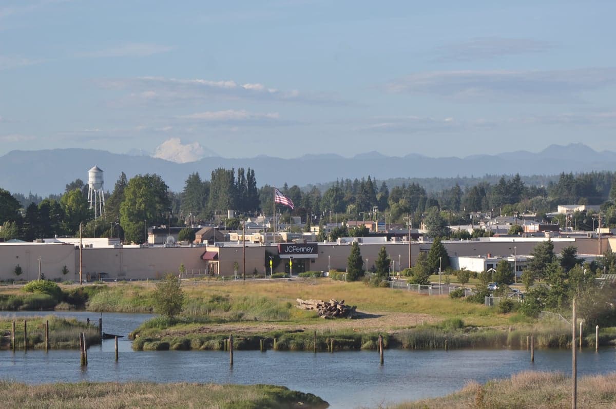
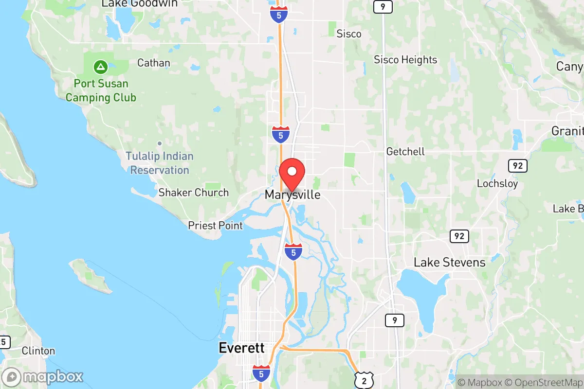
Marysville, Washington, sits in a precarious but potentially advantageous position for those prioritizing long-term resilience and self-sufficiency. Located roughly 35 miles north of Seattle, it offers a buffer from the immediate chaos of a major metropolitan collapse while still providing access to critical supply chains and infrastructure. The city’s location along the I-5 corridor and the Snohomish River delta gives it a dual nature: a strategic chokepoint for movement and a potential funnel for unrest. For a relocator with a prepper mindset, Marysville’s real value lies not in its urban amenities but in its proximity to the Cascade foothills, the Puget Sound, and agricultural zones that could sustain a community after a major disruption.
Geographic position and natural advantages for long-term survival
Marysville’s geography is its strongest card. The city sits at the confluence of the Snohomish and Stillaguamish rivers, with the Cascade Range rising to the east and the Olympic Mountains visible to the west. This positioning provides multiple escape routes and resource zones. To the east, the Mountain Loop Highway and Forest Service roads lead into vast, sparsely populated national forest land—ideal for retreat, hunting, and foraging. To the west, Whidbey Island and the Olympic Peninsula offer maritime access and alternative food sources via fishing. The Snohomish River valley itself is fertile farmland, with existing dairy operations, berry farms, and nurseries that could be repurposed for local food production in a crisis. The area’s temperate maritime climate means mild winters and consistent rainfall, reducing the risk of drought compared to inland regions. For a survivalist, this means reliable water sources, a longer growing season, and less extreme temperature swings that could stress off-grid systems.
Risks, exposures, and proximity to fallout-relevant landmarks
The downsides are significant and must be weighed honestly. Marysville’s proximity to Seattle—a likely epicenter of civil unrest, resource riots, or a mass casualty event—is the primary liability. I-5 runs directly through the city, making it a natural corridor for refugees fleeing south or north. In a collapse scenario, Marysville could become a bottleneck, with desperate populations moving through or settling in the area. The city is also within 20 miles of Naval Air Station Whidbey Island, a strategic military installation that could be a target for conventional or asymmetric attacks. The nearby Tulalip Indian Reservation and the Quil Ceda Village commercial hub add complexity—these are sovereign lands with their own governance, which could be either a buffer or a source of friction depending on the situation. Additionally, the region sits in the Cascadia subduction zone, meaning a major earthquake (the “Big One”) is a real, if unpredictable, threat. A quake would likely destroy the I-5 bridges over the Snohomish River, cutting off Marysville from Seattle and points south, while also triggering tsunamis along the coast. The risk of a volcanic eruption from Glacier Peak (about 60 miles east) is lower but not zero, with lahars potentially reaching the river valleys. For the prepper, these are not deal-breakers but factors that demand layered planning: multiple evacuation routes, seismic retrofits, and stored supplies for a weeks-long isolation scenario.
Practical resilience for a relocator: food, water, energy, and defensibility
For a single individual or family looking to establish a resilient base, Marysville offers a mixed bag. Water is abundant—the rivers and high annual rainfall (around 38 inches) mean that with proper catchment and filtration, a household can secure its own supply. The shallow groundwater table also makes well drilling feasible on larger lots outside the city core. Food resilience is moderate: the surrounding farmland is productive, but much of it is tied to commercial agriculture that could break down in a crisis. A relocator would need to secure land for personal gardening or partner with local farmers. The Tulalip Bay and Puget Sound provide year-round seafood—salmon, shellfish, and crab—but access is regulated and could become contested. Energy is a weak point. The grid is reliant on hydroelectric power from the Columbia and Skagit rivers, which is generally reliable but vulnerable to earthquake damage or cyberattack. Solar potential is mediocre due to frequent cloud cover, though micro-hydro from nearby streams or a propane generator are viable alternatives. Defensibility is the biggest challenge. Marysville’s flat, river-bottom terrain offers few natural chokepoints or high ground. The city’s sprawl—strip malls, subdivisions, and industrial parks—makes it hard to secure a single property without visible fortification. The best strategy is to locate on the eastern edge, near the foothills, where rural roads and forest cover provide more options for concealment and retreat. The local gun culture is present but not dominant; Washington State has relatively restrictive firearm laws, so stockpiling and training should be done discreetly and in compliance with regulations.
Overall, Marysville is a calculated risk for the strategic relocator. It is not a remote bunker site—it is a buffer zone with access to resources and escape routes, but also with exposure to the chaos of a failing urban center. The smart play here is to treat Marysville as a staging ground: a place to build a self-sufficient homestead with a vehicle capable of heading east into the Cascades or north into Canada if the situation deteriorates. The city’s real strength is its position between the urban collapse zone and the wilderness, giving you options that a deep-rural or deep-urban location would not. If you are willing to invest in water independence, food storage, and a solid evacuation plan, Marysville can work as a long-term base. But if you are looking for a location that is inherently defensible and far from any major population center, look farther east or north—this is not that place. It is a compromise, and in a world of increasing instability, compromises can be deadly if not managed carefully.
* Values derived from national, state, county, city and local statistics and may differ in a specific area. Last updated: 2026-05-03T20:38:55.000Z
Narrative content on this page is AI-generated and may contain mistakes. Verify any details that matter before acting on them.
ReloMaps may earn a commission from affiliate links at no extra cost to you.