Photo: Wikipedia
Strategic Assessment of Milton, GA
Meaningful friction. Expect exposure to either population pressure, blast zones, or natural disaster risk. Consider buying a retreat property.
What does the Strategic Assessment tell us?
Our Strategic Assessment grades tactical survivability of an area. Major population centers, military targets, fallout zones, natural disasters, and border exposure all drive risk — lower exposure means a more defensible position in a crisis.
This is heavily inspired by Joel Skousen's Strategic Relocation book. Highly recommended you checkout the book ($)What does this tell us?
Our Strategic Assessment grades tactical survivability of an area. Major population centers, military targets, fallout zones, natural disasters, and border exposure all drive risk — lower exposure means a more defensible position in a crisis.
This is heavily inspired by Joel Skousen's Strategic Relocation book. Highly recommended you checkout the book ($)Strategic Pillars

Key Distances
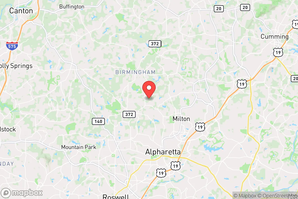
Regional Safe Places
Below is our recommended "safe zones" in Georgia and the surrounding area based on our strategic heuristics. For most people, it's unrealistic to live in a “safe zone” full-time due to work, family or other personal reasons. They tend to be more rural. However, many of these areas are perfect for second homes and retreat properties that double as a vacation home or even a short-term rental.


Important Note: For informational purposes only. This does not mean nothing bad ever happens in the green zones. Please use common sense. This is based on public data and modeled with AI. We tried to take a conservative approach but mistakes happen. We update this regularly as new information becomes available.
Solar Generator Recommendations
Backup power matters more here than in safer locations. We've picked three solar generators across budgets and capacity tiers — start with the budget unit if you only need a few essentials, or step up if you want to run a fridge and HVAC for days at a time.

Jackery Portable Power Station Explorer 300
Budget OptionPower on the Go: Weighing only 11 lbs, it's convenient to set up and store with book-sized foldable solar panels

BLUETTI Portable Power Station AC180
Designed for both indoor and outdoor scenarios, AC180 is highly capable as it has a robost capacity and continuous output power.

EF ECOFLOW DELTA Pro Ultra Power Station
Upgraded PickEcoFlow DELTA Pro Ultra is a whole-home energy system designed to grow with your family. Integrated with the Smart Home Panel 2, it scales to meet your evolving energy needs — keeping your home powered, intelligent, and secure through every stage of life.
We earn a commission, at no additional cost to you.
Strategic Assessment Analysis
Milton, Georgia, sits in a strategic sweet spot that few metro-adjacent towns can claim: close enough to Atlanta’s economic engine to sustain a professional career, yet far enough north to offer genuine geographic buffer from the cascading failures that could overwhelm a major city. Perched at the southern edge of the Appalachian foothills, this Fulton County enclave of roughly 42,000 residents benefits from higher elevation, lower population density, and a road network that doesn’t funnel everyone into a single choke point. For a relocator thinking in terms of decades—not just next year’s commute—Milton presents a defensible base of operations that balances access with isolation, provided you understand where the real vulnerabilities lie.
Geographic position and natural advantages for long-term security
Milton’s location at the intersection of Georgia 400, State Route 9, and State Route 372 gives residents multiple egress routes out of the metro area, a critical factor when a single interstate closure or civil disturbance can trap tens of thousands. The city sits on the Chattahoochee River watershed, with the river forming its western boundary—a natural barrier that slows unauthorized movement and provides a reliable freshwater source for those who secure riparian access. Elevation here averages 1,000 to 1,200 feet above sea level, which means cooler summer temperatures, less flood risk than downstream suburbs, and a vantage point that makes situational awareness easier. The surrounding terrain is a mix of hardwood forest, rolling hills, and horse farms—land that can support small-scale agriculture, rainwater catchment, and off-grid energy systems without drawing attention. Unlike flat, grid-locked suburbs to the south, Milton’s topography offers natural concealment and defensible positions for a prepared household.
Risks, exposures, and proximity to fallout-relevant landmarks
The most significant vulnerability is Milton’s 35-mile proximity to downtown Atlanta. In a mass casualty event—whether from a coordinated attack, infrastructure collapse, or pandemic resurgence—the city sits within the likely radius of secondary effects: refugees fleeing south on GA 400, supply chain interruptions at the Port of Savannah and Hartsfield-Jackson, and potential grid instability from the regional power network. Fulton County itself is a governance risk; its county commission and school board lean heavily progressive, and during a crisis, policy decisions made downtown could override local Milton ordinances. There is also the Lake Lanier dam complex roughly 25 miles northeast—a critical infrastructure target that, if compromised, would send floodwaters down the Chattahoochee corridor and threaten Milton’s western riverfront properties. On the positive side, Milton has no major industrial chemical plants, no nuclear reactors within 50 miles (the closest is Plant Hatch in Baxley, over 150 miles away), and no major military bases that would make it a primary target. The real threat is human tide, not blast radius.
Practical resilience for a relocator: food, water, energy, and defensibility
For a serious prepper, Milton offers workable conditions with deliberate effort. Water is the strongest asset: the Chattahoochee River, combined with numerous creeks and private ponds, means a household with a Berkey filter or sand filtration system can secure drinking water indefinitely. Well water is common on larger lots outside the city’s core subdivisions, and the water table sits at a manageable 30–60 feet in most areas. Food production is viable but not automatic—the clay-heavy Piedmont soil requires raised beds or heavy amendment, but the growing season runs from April to October, long enough for corn, beans, squash, and root vegetables. Local ordinances allow backyard chickens and goats on parcels over two acres, and several equestrian properties already have barns that can be converted for small livestock. Energy resilience is mixed: Georgia Power’s grid is reliable in normal times but vulnerable to ice storms and cyberattack. Solar is permitted without HOA interference in unincorporated areas, and many newer homes have natural gas hookups that can run generators indefinitely. Defensibility depends on your specific lot. The ideal property is set back from the road, screened by trees, with a single driveway approach and a rear escape route onto a secondary road. Subdivisions with one entrance are a liability—they become traps. Milton’s rural-residential zoning (minimum one-acre lots in most areas) gives you room to create a perimeter, store supplies, and maintain operational security without neighbors peering into your business. The local sheriff’s office is professional and well-funded, but in a grid-down scenario, response times will stretch to hours or days. Your plan must assume self-reliance for at least 30 days.
Community, culture, and the human factor in a crisis
The social fabric in Milton is a double-edged sword. On one hand, the population is overwhelmingly conservative, family-oriented, and property-conscious—the kind of people who organize neighborhood watches, keep firearms, and help a neighbor clear a fallen tree without being asked. The city’s strong sense of local identity (it incorporated in 2006 specifically to avoid annexation by Alpharetta) means residents are invested in their community’s survival, not just their own. On the other hand, this is an affluent area with a median household income above $150,000, and many families are two-income professionals who commute to Atlanta. In a prolonged crisis, those commuters will be stranded or forced to abandon vehicles, and the suburban infrastructure—strip malls, gas stations, grocery stores—will empty within 48 hours. Your neighbors may have resources, but they may also have dependencies (elderly parents, young children, medical needs) that draw on shared supplies. The best strategy is to build relationships now, quietly, with two or three like-minded households. A mutual assistance pact with a retired couple who have a well and a veteran who knows land navigation is worth more than a year’s worth of freeze-dried food stored alone.
Overall strategic picture for a conservative relocator
Milton is not a bug-out location—it’s a live-in-place stronghold for someone who can afford the premium and is willing to do the work. The trade-off is clear: you pay for proximity to Atlanta’s economy and culture, and you accept the risk that comes with that proximity. For a single professional or a family with school-age children, Milton offers excellent schools (Fulton County’s top-rated, with strong parental involvement), low crime rates, and a community that shares your values. For a prepper, it offers water, defensible terrain, and a social environment where preparedness is seen as prudent, not paranoid. The weaknesses—grid dependency, county-level political risk, and the human tide from the south—are manageable with planning. Buy on the western side near the river, secure a well and solar, build a trusted network, and keep your OPSEC tight. Milton won’t save you from every scenario, but it gives you a fighting chance in the ones that matter most.
* Values derived from national, state, county, city and local statistics and may differ in a specific area. Last updated: 2026-04-23T05:06:21.000Z
Narrative content on this page is AI-generated and may contain mistakes. Verify any details that matter before acting on them.
ReloMaps may earn a commission from affiliate links at no extra cost to you.