
Photo: Wikipedia
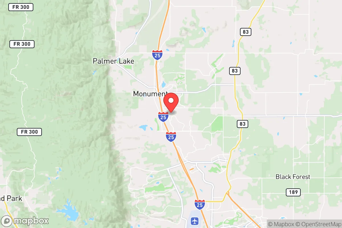
Strategic Assessment of Monument, CO
Meaningful friction. Expect exposure to either population pressure, blast zones, or natural disaster risk. Consider buying a retreat property.
What does the Strategic Assessment tell us?
Our Strategic Assessment grades tactical survivability of an area. Major population centers, military targets, fallout zones, natural disasters, and border exposure all drive risk — lower exposure means a more defensible position in a crisis.
This is heavily inspired by Joel Skousen's Strategic Relocation book. Highly recommended you checkout the book ($)What does this tell us?
Our Strategic Assessment grades tactical survivability of an area. Major population centers, military targets, fallout zones, natural disasters, and border exposure all drive risk — lower exposure means a more defensible position in a crisis.
This is heavily inspired by Joel Skousen's Strategic Relocation book. Highly recommended you checkout the book ($)Strategic Pillars

Key Distances
Regional Safe Places
Below is our recommended "safe zones" in Colorado and the surrounding area based on our strategic heuristics. For most people, it's unrealistic to live in a “safe zone” full-time due to work, family or other personal reasons. They tend to be more rural. However, many of these areas are perfect for second homes and retreat properties that double as a vacation home or even a short-term rental.


Important Note: For informational purposes only. This does not mean nothing bad ever happens in the green zones. Please use common sense. This is based on public data and modeled with AI. We tried to take a conservative approach but mistakes happen. We update this regularly as new information becomes available.
Solar Generator Recommendations
Backup power matters more here than in safer locations. We've picked three solar generators across budgets and capacity tiers — start with the budget unit if you only need a few essentials, or step up if you want to run a fridge and HVAC for days at a time.

Jackery Portable Power Station Explorer 300
Budget OptionPower on the Go: Weighing only 11 lbs, it's convenient to set up and store with book-sized foldable solar panels

BLUETTI Portable Power Station AC180
Designed for both indoor and outdoor scenarios, AC180 is highly capable as it has a robost capacity and continuous output power.

EF ECOFLOW DELTA Pro Ultra Power Station
Upgraded PickEcoFlow DELTA Pro Ultra is a whole-home energy system designed to grow with your family. Integrated with the Smart Home Panel 2, it scales to meet your evolving energy needs — keeping your home powered, intelligent, and secure through every stage of life.
We earn a commission, at no additional cost to you.
Strategic Assessment Analysis
Monument, Colorado, offers a compelling strategic position for those prioritizing resilience and self-sufficiency, sitting at the northern edge of the Colorado Front Range where the plains meet the foothills. Its location along the I-25 corridor provides a buffer—roughly 15 miles north of Colorado Springs and 50 miles south of Denver—that places it outside the immediate blast radius or grid collapse zone of a major metropolitan target, while still allowing access to regional resources. The town’s elevation at over 7,000 feet and its position on the Palmer Divide create a natural defensive advantage, with cooler temperatures, lower humidity, and a topography that complicates both ground movement and airborne threats. For a relocator with a prepper mindset, Monument represents a rare blend of proximity to essential infrastructure and enough geographic separation to buy critical time during a crisis.
Geographic position and natural advantages for long-term survival
Monument sits on a high plateau that acts as a natural watershed divide, with drainage flowing both east toward the Arkansas River basin and west toward the South Platte. This means the area is less prone to the flash flooding that plagues lower-elevation Front Range towns, and the local water table is generally more reliable for well drilling than in the arid plains further east. The surrounding Pike National Forest and Black Forest region provide dense tree cover, which offers both concealment and a source of timber for heating and construction—critical in a prolonged grid-down scenario. The terrain is a mix of rolling hills, granite outcroppings, and pine forests, which creates natural chokepoints along the few roads leading into town. For a survivalist, this defensibility is a major asset: the only primary routes are I-25, Highway 105, and a handful of county roads, all of which can be monitored or blocked with minimal effort. The area’s average annual snowfall of roughly 60 inches also provides a renewable water source, though it demands proper storage and melt systems. Monument’s position on the Palmer Divide also means it experiences less severe wildfire risk than the heavily forested areas west of Colorado Springs, though it is not immune—the 2013 Black Forest Fire burned just south of town, a reminder that mitigation is still necessary.
Risks, exposures, and proximity to fallout-relevant landmarks
The most significant strategic vulnerability for Monument is its proximity to Colorado Springs, home to Peterson Space Force Base, Schriever Space Force Base, and the U.S. Air Force Academy. In a major conflict or nuclear exchange, these are high-priority targets, and Monument lies within the potential fallout plume zone depending on wind direction. A ground burst at Peterson, roughly 20 miles south, could deposit lethal fallout across northern El Paso County within hours, making a pre-planned evacuation route south or east essential. Denver’s urban core and its associated military and government infrastructure (including Buckley Space Force Base and the Denver Federal Center) are about 50 miles north, which is outside the immediate blast radius for most warheads but still within range of secondary effects like EMP or supply chain collapse. The I-25 corridor itself is a double-edged sword: it provides rapid evacuation south toward New Mexico or west toward the mountains, but it also funnels refugees and looters from the cities during a collapse. Monument’s small population (roughly 10,000 residents) means it lacks the hospital capacity, police force, and food reserves to absorb a sudden influx of evacuees from Colorado Springs or Denver. The town’s water supply is primarily from groundwater wells and the Monument Creek watershed, which could be contaminated by fallout or upstream industrial spills—a prepper should plan for at least two weeks of stored water per person, with a Berkey or similar filtration system as backup. Wildfire risk is moderate but real, especially in the forested subdivisions west of I-25, and the area’s dry lightning season (June–August) can ignite fast-moving fires that cut off escape routes.
Practical resilience for a relocator: food, water, energy, and defensibility
For a relocator serious about self-sufficiency, Monument’s practical resilience hinges on a few key factors. The local soil is rocky and alkaline, making large-scale gardening challenging without raised beds and soil amendment, but the short growing season (roughly 100 frost-free days) is workable for cold-hardy crops like potatoes, kale, and root vegetables. The area has a strong rural homesteading culture, with several feed stores, a local farmers’ market, and a network of small-scale livestock operations—chickens, goats, and rabbits are common, and zoning in unincorporated areas allows for them. Water is the critical limiting factor: while the water table is decent, new wells can cost $10,000–$20,000 and may require permits and testing for uranium and radon, which are naturally occurring in the region. Rainwater collection is legal in Colorado but restricted to 110 gallons per property without a permit, so a prepper should prioritize a large cistern system and a backup hand pump. Energy resilience is strong: the area gets over 300 days of sunshine annually, making solar panels a viable primary or backup power source, and many homes already have propane tanks for heating and cooking. Wood stoves are common in older homes, and the surrounding national forest provides ample fuel, though cutting permits are required. Defensibility is excellent for a small group: the town’s layout, with its winding roads, dense tree lines, and limited entry points, makes it easy to establish observation posts and roadblocks. The local sheriff’s office (El Paso County) is well-funded and generally responsive, but in a prolonged crisis, residents would need to rely on mutual aid networks—the area has a strong tradition of church-based and neighborhood watch groups that could be activated. The biggest practical gap is medical: Monument has no hospital, only a small urgent care clinic, and the nearest trauma center is in Colorado Springs, which would be overwhelmed or inaccessible during a major event. A relocator should bring a comprehensive medical kit, training in field medicine, and a plan for chronic conditions like diabetes or heart disease.
Overall, Monument presents a solid strategic option for the conservative prepper who wants to stay within striking distance of Front Range resources while maintaining a defensible, self-sufficient homestead. It is not a remote bug-out location—it is a suburban-rural hybrid that requires active preparation, community building, and a realistic assessment of its vulnerabilities. The proximity to military targets and the I-25 corridor means you cannot afford to be complacent about evacuation routes, fallout protection, and water storage. But for someone willing to invest in a well, solar panels, a wood stove, and a strong local network, Monument offers a rare combination of natural defensibility, climate resilience, and access to the broader Western supply chain. It is a place to hunker down, not to disappear—and for the strategic relocator, that balance is often the most practical path forward.
* Values derived from national, state, county, city and local statistics and may differ in a specific area. Last updated: 2026-04-29T00:40:10.000Z
Narrative content on this page is AI-generated and may contain mistakes. Verify any details that matter before acting on them.
ReloMaps may earn a commission from affiliate links at no extra cost to you.