Photo: Wikipedia
Strategic Assessment of Newport, RI
Multiple tactical vulnerabilities. Population density, target proximity, or disaster risk are likely compounding. A retreat property and exit planning is required.
What does the Strategic Assessment tell us?
Our Strategic Assessment grades tactical survivability of an area. Major population centers, military targets, fallout zones, natural disasters, and border exposure all drive risk — lower exposure means a more defensible position in a crisis.
This is heavily inspired by Joel Skousen's Strategic Relocation book. Highly recommended you checkout the book ($)What does this tell us?
Our Strategic Assessment grades tactical survivability of an area. Major population centers, military targets, fallout zones, natural disasters, and border exposure all drive risk — lower exposure means a more defensible position in a crisis.
This is heavily inspired by Joel Skousen's Strategic Relocation book. Highly recommended you checkout the book ($)Strategic Pillars

Key Distances
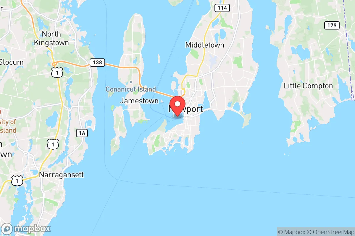
Regional Safe Places
Below is our recommended "safe zones" in Rhode Island and the surrounding area based on our strategic heuristics. For most people, it's unrealistic to live in a “safe zone” full-time due to work, family or other personal reasons. They tend to be more rural. However, many of these areas are perfect for second homes and retreat properties that double as a vacation home or even a short-term rental.


Important Note: For informational purposes only. This does not mean nothing bad ever happens in the green zones. Please use common sense. This is based on public data and modeled with AI. We tried to take a conservative approach but mistakes happen. We update this regularly as new information becomes available.
Solar Generator Recommendations
Backup power matters more here than in safer locations. We've picked three solar generators across budgets and capacity tiers — start with the budget unit if you only need a few essentials, or step up if you want to run a fridge and HVAC for days at a time.

Jackery Portable Power Station Explorer 300
Budget OptionPower on the Go: Weighing only 11 lbs, it's convenient to set up and store with book-sized foldable solar panels

BLUETTI Portable Power Station AC180
Designed for both indoor and outdoor scenarios, AC180 is highly capable as it has a robost capacity and continuous output power.

EF ECOFLOW DELTA Pro Ultra Power Station
Upgraded PickEcoFlow DELTA Pro Ultra is a whole-home energy system designed to grow with your family. Integrated with the Smart Home Panel 2, it scales to meet your evolving energy needs — keeping your home powered, intelligent, and secure through every stage of life.
We earn a commission, at no additional cost to you.
Strategic Assessment Analysis
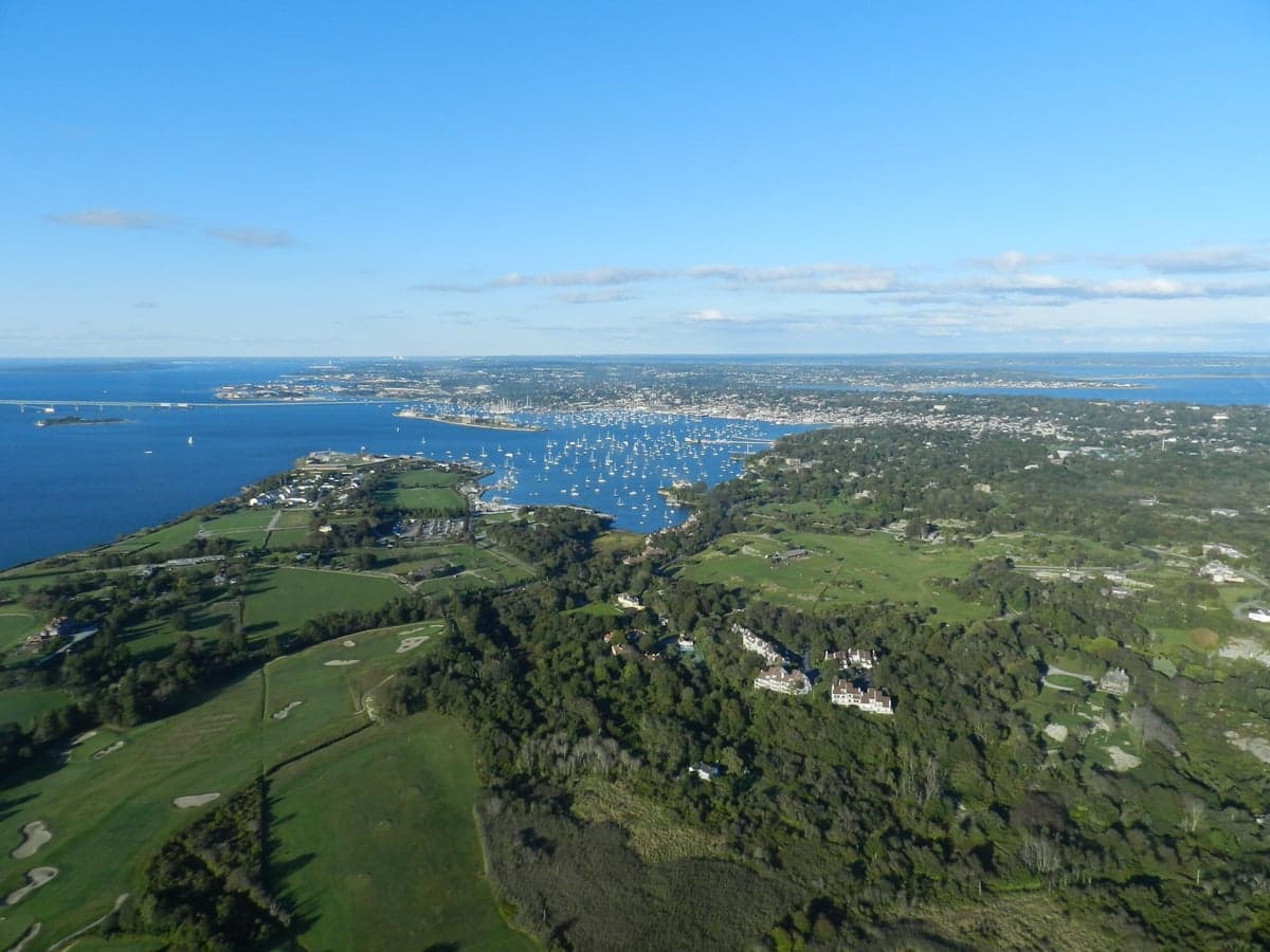
Newport, Rhode Island, presents a complex strategic picture for the conservative prepper or survivalist. While its coastal beauty and historic charm are undeniable, its viability as a long-term resilience hub is severely compromised by its geography, population density, and proximity to high-value, high-risk targets. The city’s location on Aquidneck Island, connected to the mainland by only two bridges and a single narrow causeway, creates a natural chokepoint that is both a defensive liability and a potential trap. For a relocator prioritizing self-sufficiency and security in a deteriorating national scenario, Newport offers a handful of tactical advantages but far more significant strategic vulnerabilities that must be weighed with cold, hard pragmatism.
Geographic position and natural advantages: island isolation or a gilded cage?
Newport’s position at the southern tip of Aquidneck Island, commanding the entrance to Narragansett Bay, is historically a naval and commercial asset. In a prepper context, the island’s 15-mile length and 3-mile width create a finite, defensible perimeter—but only if you control the water. The two road bridges (the Pell Bridge and the Mount Hope Bridge) are the only vehicular lifelines to the mainland, and both are vulnerable to sabotage, accident, or deliberate closure during unrest. The third option, the Sakonnet River Bridge, connects to the eastern shore of the state, but still requires crossing water. In a collapse scenario, these bridges become the single point of failure for supply, evacuation, or reinforcement. The natural deep-water harbor, while beautiful, is also a strategic liability: it is a known naval anchorage and a potential target for any adversary seeking to disrupt East Coast maritime traffic. The island’s limited freshwater supply—primarily from the North End Reservoir and a few small ponds—cannot support a population surge or a prolonged siege. The soil is rocky and thin, making large-scale agriculture difficult without significant investment in raised beds and greenhouses. The maritime climate, with its moderate temperatures and ample rainfall, is a plus for gardening, but the salt spray and nor’easters can damage infrastructure and crops. For a relocator, the island’s natural beauty is a trap if it lulls you into ignoring the logistical nightmare of getting on or off the rock when things go sideways.
Risks, exposures, and proximity to fallout-relevant landmarks
Newport’s greatest strategic weakness is its proximity to high-value, high-risk targets that would be primary objectives in any major conflict or domestic unrest. Naval Station Newport, a major U.S. Navy training center and home to the Naval War College, is located within the city limits. This makes Newport a Tier-1 target for any state actor or terrorist group seeking to cripple U.S. naval command and control. The base houses sensitive communications, intelligence facilities, and a large concentration of military personnel. In a nuclear exchange or a conventional strike, Newport is a primary target. Even in a non-nuclear scenario—civil unrest, cyberattack, or EMP—the base’s presence draws federal attention, military checkpoints, and potential martial law, which can restrict civilian movement and create a police-state atmosphere. Beyond the base, the city’s dense historic district, with its narrow streets and aging wooden buildings, is a fire hazard and a nightmare for evacuation. The Claiborne Pell Bridge, a suspension bridge, is a single-point-of-failure that could be blocked by a single vehicle accident or a deliberate act, trapping tens of thousands of residents on the island. The nearby Quonset Point industrial park and the Port of Davisville, both on the mainland, are logistics hubs that could become targets or chokepoints. The prevailing winds from the west mean fallout from a strike on Boston (70 miles north) or Providence (30 miles north) could drift over the island, contaminating water and soil. For a relocator, the calculus is simple: being near a major naval base and two major cities in a time of national crisis is not a survival advantage—it’s a liability.
Practical resilience for a relocator: food, water, energy, and defensibility
For the individual or family committed to making Newport work, the practical challenges are steep but not insurmountable—if you have deep pockets and a plan. Food security is the biggest hurdle. The island imports nearly all of its food via the bridges. Local agriculture is limited to a few small farms (e.g., Aquidneck Farms, Sweet Berry Farm) that produce seasonal fruits, vegetables, and some livestock, but they cannot sustain the island’s 25,000 residents. A serious prepper would need to establish a year-round greenhouse, a root cellar, and a substantial seed bank. The maritime climate allows for cool-season crops (kale, chard, root vegetables) but limits warm-season staples. Water is the second critical vulnerability. The city’s municipal water comes from the North End Reservoir and the Lawton Valley Reservoir, both of which are vulnerable to contamination, drought, or sabotage. A well is not an option for most properties due to the island’s geology and saltwater intrusion. Rainwater catchment is legal in Rhode Island, but the salt spray can contaminate roofs, requiring first-flush diverters and filtration. Energy is a mixed bag. The grid is old and prone to outages during nor’easters. Solar is viable, but the coastal winds and salt air degrade panels faster than inland installations. A backup generator with a large fuel cache is essential, but fuel resupply after a bridge closure is impossible. Defensibility is the one bright spot. The island’s finite geography means you can theoretically secure a perimeter, but it also means you cannot retreat. The best defensive posture is a rural property on the island’s less-dense northern end (near Portsmouth or Middletown), away from the tourist-heavy waterfront. A group of like-minded families could form a mutual-assistance pact, but the island’s small size means any conflict quickly becomes everyone’s problem. For a single individual or a family, the cost of achieving true self-sufficiency on Aquidneck Island is prohibitive, and the risk of being trapped by a bridge failure or a military lockdown is high.
The overall strategic picture for Newport is one of high risk and limited reward for the conservative prepper. The island’s natural beauty, historic charm, and moderate climate are real assets, but they are outweighed by the critical vulnerabilities of bridge-dependent access, a finite freshwater supply, and the presence of a major naval base that makes the city a primary target in any national crisis. For a relocator seeking a remote, defensible, and self-sufficient location, Newport is a poor choice. The city is best suited for those who can afford to maintain a secondary, more secure property inland (e.g., in western Rhode Island or rural Connecticut) and treat Newport as a seasonal or part-time residence. If you are determined to live here, invest heavily in water storage, a robust solar-plus-battery system, a large food cache, and a plan for getting off the island within hours of a bridge closure. The bridges are your lifeline and your leash. In a world where the state of the country and the world is uncertain, Newport offers a beautiful cage—but a cage nonetheless.
* Values derived from national, state, county, city and local statistics and may differ in a specific area. Last updated: 2026-04-30T01:47:55.000Z
Narrative content on this page is AI-generated and may contain mistakes. Verify any details that matter before acting on them.
ReloMaps may earn a commission from affiliate links at no extra cost to you.